Koyelga elevation
Koyelga (Chelyabinsk), Russia elevation is 235 meters and Koyelga elevation in feet is 771 ft above sea level [src 1]. Koyelga is a populated place (feature code) with elevation that is 36 meters (118 ft) bigger than average city elevation in Russia.
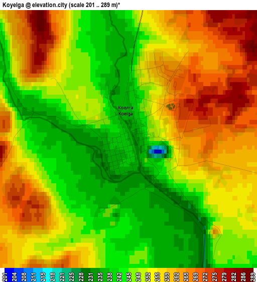
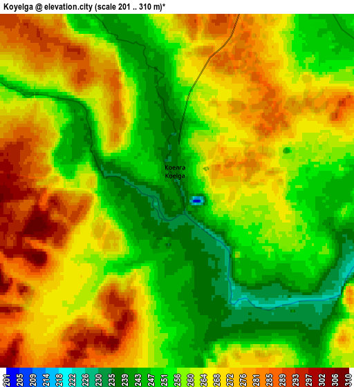
Below is the Elevation map of Koyelga, which displays elevation range with different colors. Scale of the first map is from 201 to 289 m (659 to 948 ft) with average elevation of 252.1 meters (=827 ft) [note 1]
These maps also provides idea of topography and contour of this city, they are displayed at different zoom levels. More info about maps, scale and edge coordinates you can find below images.
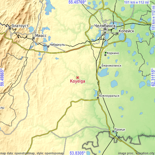
| \ | Map #1 | Map #2 | Topo.Map |
| Scale [m] | 201..289 m | 201..310 m | × |
| Scale [ft] | 659..948 ft | 659..1017 ft | × |
| Average | 252.1 m = 827 ft | 261.6 m = 858 ft | × |
| Width | 5.65 km = 3.5 mi | 11.31 km = 7 mi | 180.9 km = 112.4 mi |
| Height | 5.65 km = 3.5 mi | 11.31 km = 7 mi | 180.9 km = 112.4 mi |
| ↑Max Latitude | 54.677656° | 54.703056° | 55.45769° |
| Latitude at center | 54.65224° | 54.65224° | 54.65224° |
| ↓Min Latitude | 54.626808° | 54.60136° | 53.8305° |
| ← Min Longitude | 60.860955° | 60.817009° | 59.49865° |
| Longitude center | 60.9049° | 60.9049° | 60.9049° |
| →Max Longitude | 60.948845° | 60.992791° | 62.31115° |
Nearby cities:
Cities around Koyelga sort by population:
• Korkino elevation 241 m
41.3 km,  49°
49°
• Yuzhnoural’sk 238 m
32.5 km,  136°
136°
• Yemanzhelinsk 232 m
29 km,  66°
66°
• Plast 308 m
32 km,  190°
190°
• Roza 232 m
46.1 km, 50°
• Krasnogorskiy 246 m
21.7 km,  104°
104°
• Uvel’skiy 235 m
37.2 km,  128°
128°
• Poletayevo 244 m
44.5 km,  17°
17°
• Yetkul’ 228 m
47.7 km, 66°
• Yemanzhelinka 240 m
30.2 km,  56°
56°
• Timiryazevskiy 296 m
32.1 km,  343°
343°
• Sargazy 263 m
46.5 km,  28°
28°
Multilingual:
 En español:
Koyelga elevación 235 m.
 En France:
Koyelga élévation 235 m.


Sources and notes:
- [note 1] Map square and city borders are not equal. Map elevation data is calculated only from area inside that square.
- [src 1] Elevation data from geonames database provided with same terms of usage.
- [src 2] The elevation map of Koyelga is generated using elevation data from NASA's 3 arcsec (90m) resolution SRTM data.
- [src 3] Base (background) map © OpenStreetMap contributors tiles are generated by Geofabrik and OpenTopoMap.
Copyright & License:
This Koyelga Elevation Map is licensed under CC BY-SA. You may reuse any part from this page, if you give a proper credit by linking to this URL:
 More info on terms of use page.