Karabash elevation
Karabash (Chelyabinsk), Russia elevation is 347 meters and Karabash elevation in feet is 1138 ft above sea level [src 1]. Karabash is a populated place (feature code) with elevation that is 148 meters (486 ft) bigger than average city elevation in Russia.
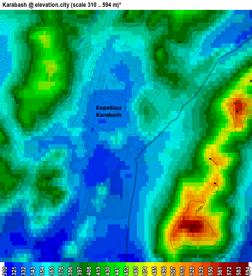
Below is the Elevation map of Karabash, which displays elevation range with different colors. Scale of the first map is from 310 to 594 m (1017 to 1949 ft) with average elevation of 379.6 meters (=1245 ft) [note 1]
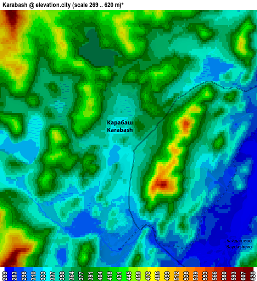
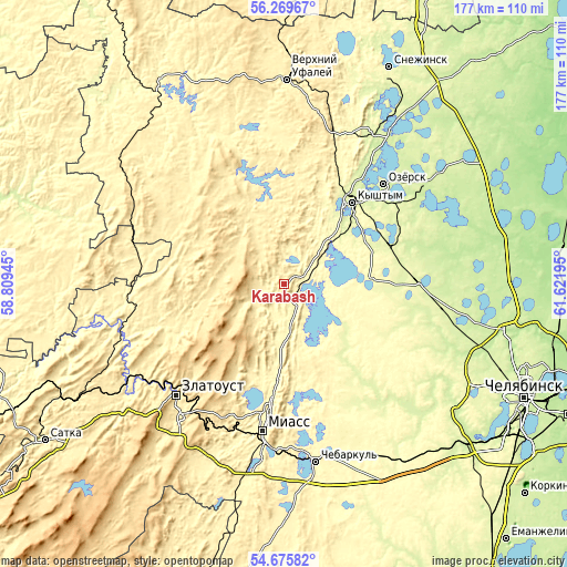
These maps also provides idea of topography and contour of this city, they are displayed at different zoom levels. More info about maps, scale and edge coordinates you can find below images.
| \ | Map #1 | Map #2 | Topo.Map |
| Scale [m] | 310..594 m | 269..620 m | × |
| Scale [ft] | 1017..1949 ft | 883..2034 ft | × |
| Average | 379.6 m = 1245 ft | 366.6 m = 1203 ft | × |
| Width | 5.54 km = 3.4 mi | 11.08 km = 6.9 mi | 177.2 km = 110.1 mi |
| Height | 5.54 km = 3.4 mi | 11.08 km = 6.9 mi | 177.2 km = 110.1 mi |
| ↑Max Latitude | 55.505695° | 55.530575° | 56.26967° |
| Latitude at center | 55.4808° | 55.4808° | 55.4808° |
| ↓Min Latitude | 55.455889° | 55.430962° | 54.67582° |
| ← Min Longitude | 60.171755° | 60.127809° | 58.80945° |
| Longitude center | 60.2157° | 60.2157° | 60.2157° |
| →Max Longitude | 60.259645° | 60.303591° | 61.62195° |
Nearby cities:
Cities around Karabash sort by population:
• Zlatoust elevation 548 m
49.6 km,  226°
226°
• Miass 341 m
48.9 km,  187°
187°
• Ozersk 251 m
43.2 km,  45°
45°
• Kyshtym 255 m
33.5 km,  39°
39°
• Kusa 368 m
51.4 km,  252°
252°
• Argayash 256 m
41.7 km,  88°
88°
• Novogornyy 265 m
39.9 km,  65°
65°
• Magnitka 386 m
36 km, 245°
• Nizhniy Ufaley 367 m
50.4 km,  343°
343°
• Turgoyak 333 m
37.3 km, 189°
• Tayginka 265 m
24.3 km, 48°
• Syrostan 386 m
50.5 km,  203°
203°
Multilingual:
 En español:
Karabash elevación 347 m.
 En France:
Karabach élévation 347 m.
 Auf Deutsch:
Karabasch höhe über dem Meeresspiegel ist 347 m.

Sources and notes:
- [note 1] Map square and city borders are not equal. Map elevation data is calculated only from area inside that square.
- [src 1] Elevation data from geonames database provided with same terms of usage.
- [src 2] The elevation map of Karabash is generated using elevation data from NASA's 3 arcsec (90m) resolution SRTM data.
- [src 3] Base (background) map © OpenStreetMap contributors tiles are generated by Geofabrik and OpenTopoMap.
Copyright & License:
This Karabash Elevation Map is licensed under CC BY-SA. You may reuse any part from this page, if you give a proper credit by linking to this URL:
 More info on terms of use page.