Kusa elevation
Kusa (Chelyabinsk), Russia elevation is 368 meters and Kusa elevation in feet is 1207 ft above sea level [src 1]. Kusa is a populated place (feature code) with elevation that is 169 meters (554 ft) bigger than average city elevation in Russia.
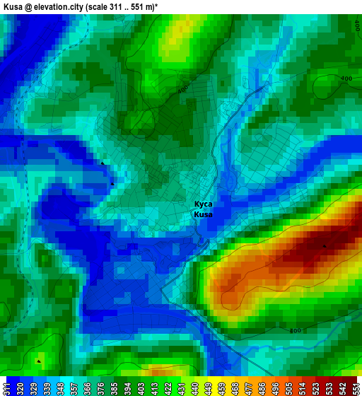
Below is the Elevation map of Kusa, which displays elevation range with different colors. Scale of the first map is from 311 to 551 m (1020 to 1808 ft) with average elevation of 376.4 meters (=1235 ft) [note 1]
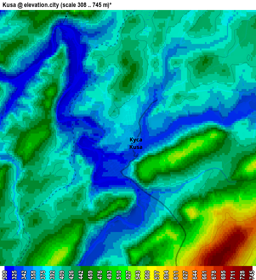
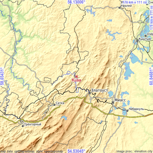
These maps also provides idea of topography and contour of this city, they are displayed at different zoom levels. More info about maps, scale and edge coordinates you can find below images.
| \ | Map #1 | Map #2 | Topo.Map |
| Scale [m] | 311..551 m | 308..745 m | × |
| Scale [ft] | 1020..1808 ft | 1010..2444 ft | × |
| Average | 376.4 m = 1235 ft | 412.6 m = 1354 ft | × |
| Width | 5.56 km = 3.5 mi | 11.12 km = 6.9 mi | 177.9 km = 110.5 mi |
| Height | 5.56 km = 3.5 mi | 11.12 km = 6.9 mi | 177.8 km = 110.5 mi |
| ↑Max Latitude | 55.363315° | 55.388284° | 56.13006° |
| Latitude at center | 55.33833° | 55.33833° | 55.33833° |
| ↓Min Latitude | 55.313329° | 55.288312° | 54.53045° |
| ← Min Longitude | 59.396615° | 59.352669° | 58.03431° |
| Longitude center | 59.44056° | 59.44056° | 59.44056° |
| →Max Longitude | 59.484505° | 59.528451° | 60.84681° |
Nearby cities:
Cities around Kusa sort by population:
• Zlatoust elevation 548 m
22.9 km,  144°
144°
• Miass 341 m
53.5 km,  127°
127°
• Satka 413 m
41.6 km,  217°
217°
• Karabash 347 m
51.4 km,  72°
72°
• Verkhniye Kigi 269 m
53.4 km,  278°
278°
• Novobelokatay 249 m
51.1 km,  323°
323°
• Magnitka 386 m
16.2 km,  86°
86°
• Berdyaush 388 m
27.1 km, 223°
• Mezhevoy 373 m
45.7 km,  246°
246°
• Turgoyak 333 m
47.8 km,  115°
115°
• Leninsk 404 m
55.5 km,  150°
150°
• Syrostan 386 m
42.3 km, 136°
Multilingual:
 En español:
Kusa elevación 368 m.
 En France:
Kusa élévation 368 m.


Sources and notes:
- [note 1] Map square and city borders are not equal. Map elevation data is calculated only from area inside that square.
- [src 1] Elevation data from geonames database provided with same terms of usage.
- [src 2] The elevation map of Kusa is generated using elevation data from NASA's 3 arcsec (90m) resolution SRTM data.
- [src 3] Base (background) map © OpenStreetMap contributors tiles are generated by Geofabrik and OpenTopoMap.
Copyright & License:
This Kusa Elevation Map is licensed under CC BY-SA. You may reuse any part from this page, if you give a proper credit by linking to this URL:
 More info on terms of use page.