Verkhniye Kigi elevation
Verkhniye Kigi (Bashkortostan Republic), Russia elevation is 269 meters and Verkhniye Kigi elevation in feet is 883 ft above sea level [src 1]. Verkhniye Kigi is a populated place (feature code) with elevation that is 70 meters (230 ft) bigger than average city elevation in Russia.
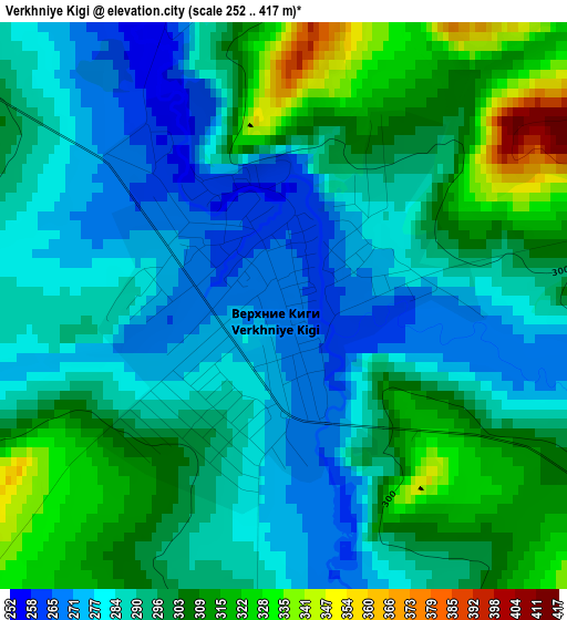
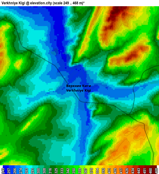
Below is the Elevation map of Verkhniye Kigi, which displays elevation range with different colors. Scale of the first map is from 252 to 417 m (827 to 1368 ft) with average elevation of 294.4 meters (=966 ft) [note 1]
These maps also provides idea of topography and contour of this city, they are displayed at different zoom levels. More info about maps, scale and edge coordinates you can find below images.
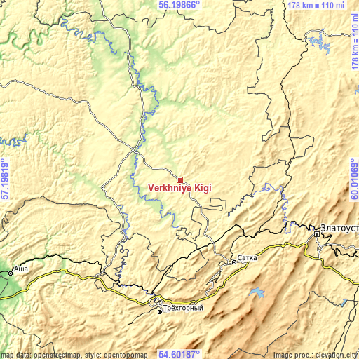
| \ | Map #1 | Map #2 | Topo.Map |
| Scale [m] | 252..417 m | 249..468 m | × |
| Scale [ft] | 827..1368 ft | 817..1535 ft | × |
| Average | 294.4 m = 966 ft | 322 m = 1056 ft | × |
| Width | 5.55 km = 3.4 mi | 11.1 km = 6.9 mi | 177.5 km = 110.3 mi |
| Height | 5.55 km = 3.4 mi | 11.1 km = 6.9 mi | 177.5 km = 110.3 mi |
| ↑Max Latitude | 55.433271° | 55.458196° | 56.19866° |
| Latitude at center | 55.40833° | 55.40833° | 55.40833° |
| ↓Min Latitude | 55.383373° | 55.358401° | 54.60187° |
| ← Min Longitude | 58.560495° | 58.516549° | 57.19819° |
| Longitude center | 58.60444° | 58.60444° | 58.60444° |
| →Max Longitude | 58.648385° | 58.692331° | 60.01069° |
Nearby cities:
Cities around Verkhniye Kigi sort by population:
• Satka elevation 413 m
49.2 km,  145°
145°
• Ust’-Katav 302 m
59.1 km,  207°
207°
• Bakal 597 m
53.5 km,  165°
165°
• Kusa 368 m
53.4 km,  98°
98°
• Mesyagutovo 212 m
26 km,  301°
301°
• Novobelokatay 249 m
39.8 km,  33°
33°
• Berdyaush 388 m
43.9 km,  128°
128°
• Kropachëvo 397 m
58.9 km,  221°
221°
• Duvan 307 m
54.5 km,  305°
305°
• Mezhevoy 373 m
28.7 km,  156°
156°
• Mursalimkino 372 m
41.3 km,  184°
184°
• Vyazovaya 371 m
58.1 km,  195°
195°
Multilingual:
 En español:
Verkhniye Kigi elevación 269 m.
 En France:
Verkhniye Kigi élévation 269 m.
 Auf Deutsch:
Verkhniye Kigi höhe über dem Meeresspiegel ist 269 m.

Sources and notes:
- [note 1] Map square and city borders are not equal. Map elevation data is calculated only from area inside that square.
- [src 1] Elevation data from geonames database provided with same terms of usage.
- [src 2] The elevation map of Verkhniye Kigi is generated using elevation data from NASA's 3 arcsec (90m) resolution SRTM data.
- [src 3] Base (background) map © OpenStreetMap contributors tiles are generated by Geofabrik and OpenTopoMap.
Copyright & License:
This Verkhniye Kigi Elevation Map is licensed under CC BY-SA. You may reuse any part from this page, if you give a proper credit by linking to this URL:
 More info on terms of use page.