Kyshtym elevation
Kyshtym (Chelyabinsk), Russia elevation is 255 meters and Kyshtym elevation in feet is 837 ft above sea level [src 1]. Kyshtym is a populated place (feature code) with elevation that is 56 meters (184 ft) bigger than average city elevation in Russia.
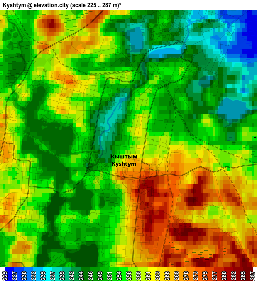
Below is the Elevation map of Kyshtym, which displays elevation range with different colors. Scale of the first map is from 225 to 287 m (738 to 942 ft) with average elevation of 255.6 meters (=839 ft) [note 1]
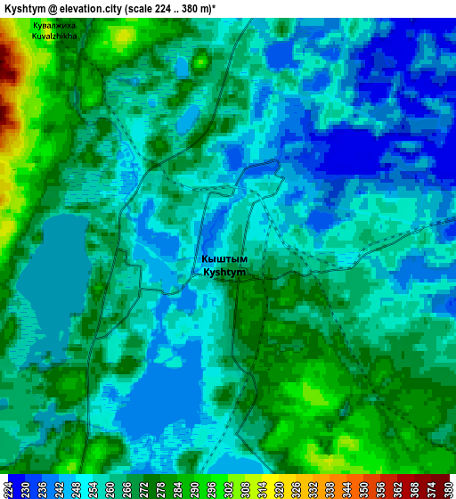
These maps also provides idea of topography and contour of this city, they are displayed at different zoom levels. More info about maps, scale and edge coordinates you can find below images.
| \ | Map #1 | Map #2 | Topo.Map |
| Scale [m] | 225..287 m | 224..380 m | × |
| Scale [ft] | 738..942 ft | 735..1247 ft | × |
| Average | 255.6 m = 839 ft | 261.6 m = 858 ft | × |
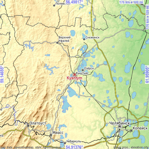
| Width | 5.51 km = 3.4 mi | 11.01 km = 6.8 mi | 176.2 km = 109.5 mi |
| Height | 5.51 km = 3.4 mi | 11.01 km = 6.8 mi | 176.2 km = 109.5 mi |
| ↑Max Latitude | 55.738748° | 55.76348° | 56.49817° |
| Latitude at center | 55.714° | 55.714° | 55.714° |
| ↓Min Latitude | 55.689237° | 55.664458° | 54.91376° |
| ← Min Longitude | 60.508855° | 60.464909° | 59.14655° |
| Longitude center | 60.5528° | 60.5528° | 60.5528° |
| →Max Longitude | 60.596745° | 60.640691° | 61.95905° |
Nearby cities:
Cities around Kyshtym sort by population:
• Ozersk elevation 251 m
10.5 km,  63°
63°
• Snezhinsk 275 m
42.7 km,  15°
15°
• Verkhniy Ufaley 375 m
42.7 km,  332°
332°
• Kasli 229 m
23.6 km,  33°
33°
• Karabash 347 m
33.5 km,  219°
219°
• Argayash 256 m
32.3 km,  140°
140°
• Novogornyy 265 m
17.7 km,  121°
121°
• Vishnëvogorsk 288 m
31.5 km,  12°
12°
• Tyubuk 236 m
45 km, 32°
• Nizhniy Ufaley 367 m
42 km,  302°
302°
• Tayginka 265 m
10.4 km,  195°
195°
• Cheremshanka 425 m
48.4 km,  338°
338°
Multilingual:
 En español:
Kyshtym elevación 255 m.
 En France:
Kyshtym élévation 255 m.


Sources and notes:
- [note 1] Map square and city borders are not equal. Map elevation data is calculated only from area inside that square.
- [src 1] Elevation data from geonames database provided with same terms of usage.
- [src 2] The elevation map of Kyshtym is generated using elevation data from NASA's 3 arcsec (90m) resolution SRTM data.
- [src 3] Base (background) map © OpenStreetMap contributors tiles are generated by Geofabrik and OpenTopoMap.
Copyright & License:
This Kyshtym Elevation Map is licensed under CC BY-SA. You may reuse any part from this page, if you give a proper credit by linking to this URL:
 More info on terms of use page.