Svetlyy elevation
Svetlyy (Orenburg Oblast), Russia elevation is 305 meters and Svetlyy elevation in feet is 1001 ft above sea level [src 1]. Svetlyy is a populated place (feature code) with elevation that is 106 meters (348 ft) bigger than average city elevation in Russia.
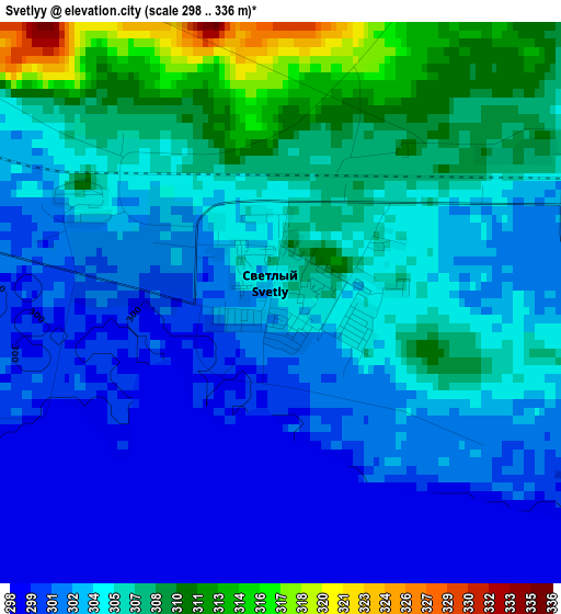
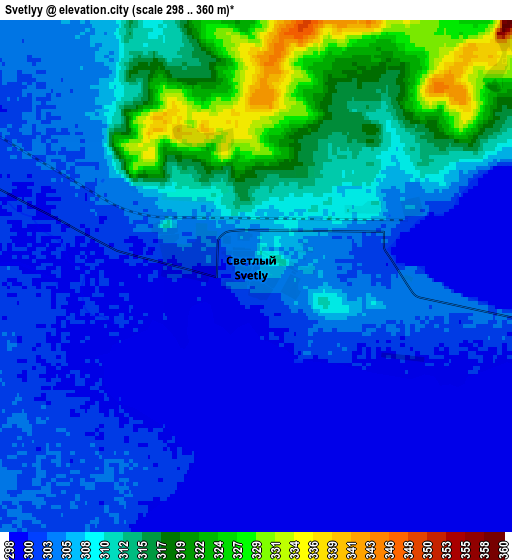
Below is the Elevation map of Svetlyy, which displays elevation range with different colors. Scale of the first map is from 298 to 336 m (978 to 1102 ft) with average elevation of 304.4 meters (=999 ft) [note 1]
These maps also provides idea of topography and contour of this city, they are displayed at different zoom levels. More info about maps, scale and edge coordinates you can find below images.
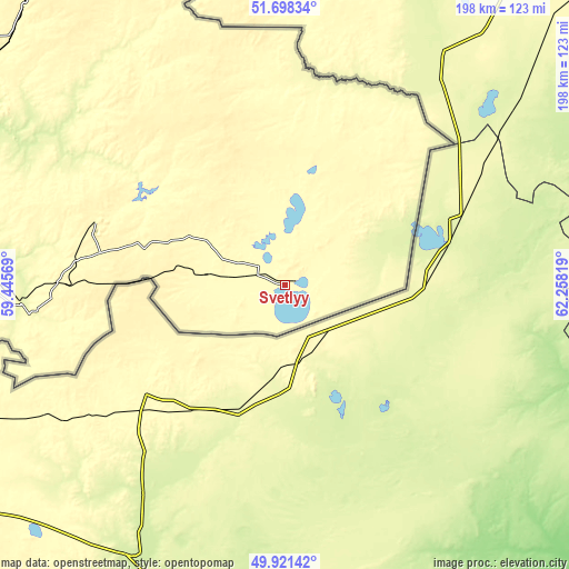
| \ | Map #1 | Map #2 | Topo.Map |
| Scale [m] | 298..336 m | 298..360 m | × |
| Scale [ft] | 978..1102 ft | 978..1181 ft | × |
| Average | 304.4 m = 999 ft | 306.7 m = 1006 ft | × |
| Width | 6.17 km = 3.8 mi | 12.35 km = 7.7 mi | 197.6 km = 122.8 mi |
| Height | 6.17 km = 3.8 mi | 12.35 km = 7.7 mi | 197.6 km = 122.8 mi |
| ↑Max Latitude | 50.846086° | 50.873825° | 51.69834° |
| Latitude at center | 50.81833° | 50.81833° | 50.81833° |
| ↓Min Latitude | 50.790558° | 50.762769° | 49.92142° |
| ← Min Longitude | 60.807995° | 60.764049° | 59.44569° |
| Longitude center | 60.85194° | 60.85194° | 60.85194° |
| →Max Longitude | 60.895885° | 60.939831° | 62.25819° |
Nearby cities:
Cities around Svetlyy sort by population:
• Orsk elevation 192 m
165.5 km,  285°
285°
• Yasnyy 356 m
72.6 km, 289°
• Novoorsk 214 m
144.8 km,  295°
295°
• Bredy 302 m
181 km,  348°
348°
• Dombarovskiy 271 m
92.6 km,  265°
265°
• Energetik 269 m
176.3 km,  305°
305°
• Adamovka 284 m
100.9 km,  320°
320°
• Kvarkeno 281 m
160.9 km,  330°
330°
• Krasnoyarskiy 318 m
143.7 km, 332°
• Shil’da 336 m
133.7 km, 325°
• Yelizavetinka 312 m
130.7 km, 323°
• Alandskoye 318 m
172.8 km, 334°
Multilingual:
 En español:
Svetlyy elevación 305 m.
 En France:
Svetlyy élévation 305 m.


Sources and notes:
- [note 1] Map square and city borders are not equal. Map elevation data is calculated only from area inside that square.
- [src 1] Elevation data from geonames database provided with same terms of usage.
- [src 2] The elevation map of Svetlyy is generated using elevation data from NASA's 3 arcsec (90m) resolution SRTM data.
- [src 3] Base (background) map © OpenStreetMap contributors tiles are generated by Geofabrik and OpenTopoMap.
Copyright & License:
This Svetlyy Elevation Map is licensed under CC BY-SA. You may reuse any part from this page, if you give a proper credit by linking to this URL:
 More info on terms of use page.