Tyumentsevo elevation
Tyumentsevo (Altai Krai), Russia elevation is 159 meters and Tyumentsevo elevation in feet is 522 ft above sea level [src 1]. Tyumentsevo is a populated place (feature code) with elevation that is 40 meters (131 ft) smaller than average city elevation in Russia.
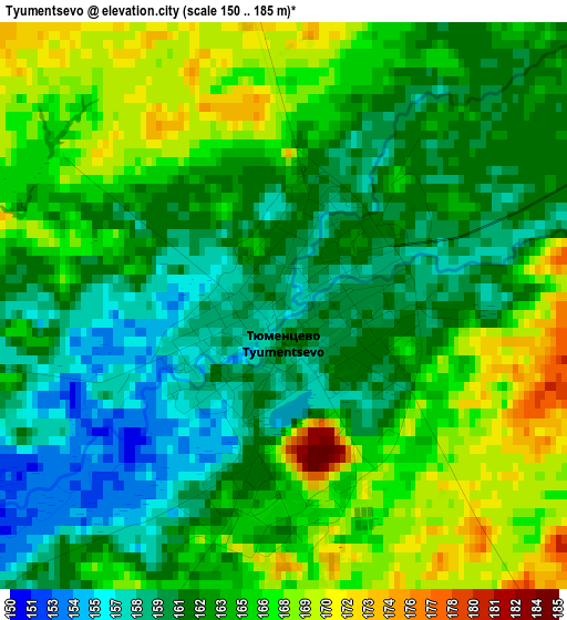
Below is the Elevation map of Tyumentsevo, which displays elevation range with different colors. Scale of the first map is from 150 to 185 m (492 to 607 ft) with average elevation of 163.4 meters (=536 ft) [note 1]
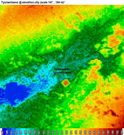
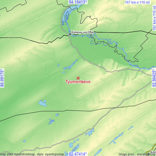
These maps also provides idea of topography and contour of this city, they are displayed at different zoom levels. More info about maps, scale and edge coordinates you can find below images.
| \ | Map #1 | Map #2 | Topo.Map |
| Scale [m] | 150..185 m | 147..194 m | × |
| Scale [ft] | 492..607 ft | 482..636 ft | × |
| Average | 163.4 m = 536 ft | 168.5 m = 553 ft | × |
| Width | 5.84 km = 3.6 mi | 11.67 km = 7.3 mi | 186.8 km = 116.1 mi |
| Height | 5.84 km = 3.6 mi | 11.67 km = 7.3 mi | 186.8 km = 116.1 mi |
| ↑Max Latitude | 53.348641° | 53.374866° | 54.15413° |
| Latitude at center | 53.3224° | 53.3224° | 53.3224° |
| ↓Min Latitude | 53.296143° | 53.26987° | 52.47414° |
| ← Min Longitude | 81.454055° | 81.410109° | 80.09175° |
| Longitude center | 81.498° | 81.498° | 81.498° |
| →Max Longitude | 81.541945° | 81.585891° | 82.90425° |
Nearby cities:
Cities around Tyumentsevo sort by population:
• Kamen’-na-Obi elevation 125 m
52.8 km,  348°
348°
• Suzun 136 m
74.3 km,  46°
46°
• Zav’yalovo 156 m
66.3 km,  215°
215°
• Mamontovo 212 m
69.1 km,  172°
172°
• Rebrikha 210 m
62.6 km,  116°
116°
• Romanovo 224 m
80.4 km,  193°
193°
• Pervomayskiy 226 m
46.4 km, 166°
• Pankrushikha 164 m
95.1 km,  306°
306°
• Bayevo 121 m
48.1 km,  263°
263°
• Shelabolikha 141 m
74.9 km,  82°
82°
• Krutikha 125 m
73.4 km,  344°
344°
• Inya 122 m
80.3 km, 75°
Multilingual:
 En español:
Tyumentsevo elevación 159 m.
 En France:
Tyumentsevo élévation 159 m.
 Auf Deutsch:
Tyumentsevo höhe über dem Meeresspiegel ist 159 m.

Sources and notes:
- [note 1] Map square and city borders are not equal. Map elevation data is calculated only from area inside that square.
- [src 1] Elevation data from geonames database provided with same terms of usage.
- [src 2] The elevation map of Tyumentsevo is generated using elevation data from NASA's 3 arcsec (90m) resolution SRTM data.
- [src 3] Base (background) map © OpenStreetMap contributors tiles are generated by Geofabrik and OpenTopoMap.
Copyright & License:
This Tyumentsevo Elevation Map is licensed under CC BY-SA. You may reuse any part from this page, if you give a proper credit by linking to this URL:
 More info on terms of use page.