Suzun elevation
Suzun (Novosibirsk Oblast), Russia elevation is 136 meters and Suzun elevation in feet is 446 ft above sea level [src 1]. Suzun is a populated place (feature code) with elevation that is 63 meters (207 ft) smaller than average city elevation in Russia.
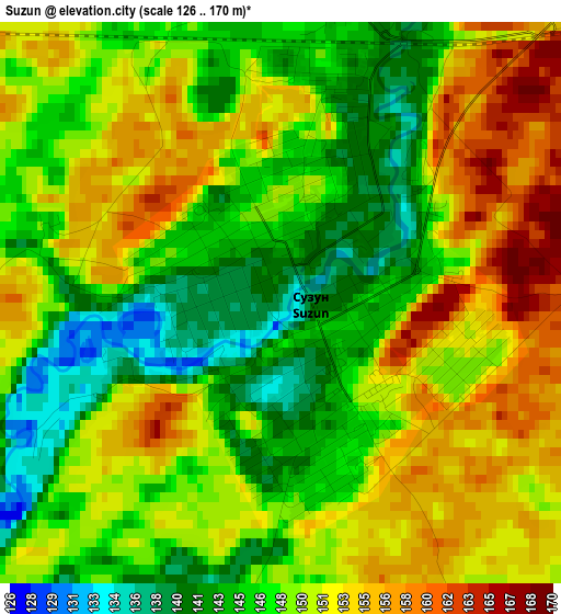
Below is the Elevation map of Suzun, which displays elevation range with different colors. Scale of the first map is from 126 to 170 m (413 to 558 ft) with average elevation of 149.1 meters (=489 ft) [note 1]
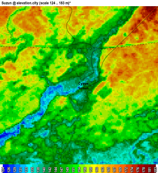
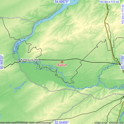
These maps also provides idea of topography and contour of this city, they are displayed at different zoom levels. More info about maps, scale and edge coordinates you can find below images.
| \ | Map #1 | Map #2 | Topo.Map |
| Scale [m] | 126..170 m | 124..183 m | × |
| Scale [ft] | 413..558 ft | 407..600 ft | × |
| Average | 149.1 m = 489 ft | 152.3 m = 500 ft | × |
| Width | 5.77 km = 3.6 mi | 11.55 km = 7.2 mi | 184.8 km = 114.8 mi |
| Height | 5.77 km = 3.6 mi | 11.55 km = 7.2 mi | 184.8 km = 114.8 mi |
| ↑Max Latitude | 53.810056° | 53.835996° | 54.60675° |
| Latitude at center | 53.7841° | 53.7841° | 53.7841° |
| ↓Min Latitude | 53.758128° | 53.732139° | 52.94499° |
| ← Min Longitude | 82.267655° | 82.223709° | 80.90535° |
| Longitude center | 82.3116° | 82.3116° | 82.3116° |
| →Max Longitude | 82.355545° | 82.399491° | 83.71785° |
Nearby cities:
Cities around Suzun sort by population:
• Kamen’-na-Obi elevation 125 m
63.7 km,  270°
270°
• Cherepanovo 276 m
85.2 km,  55°
55°
• Tal’menka 142 m
82.6 km,  87°
87°
• Pavlovsk 154 m
68.1 km,  139°
139°
• Ordynskoye 127 m
70 km,  337°
337°
• Rebrikha 210 m
79.1 km,  178°
178°
• Tyumentsevo 159 m
74.3 km,  226°
226°
• Shelabolikha 141 m
45.9 km,  153°
153°
• Krutikha 125 m
74.9 km,  285°
285°
• Nauchnyy Gorodok 174 m
89.5 km,  116°
116°
• Inya 122 m
39.1 km, 142°
• Shakhi 251 m
85.4 km,  125°
125°
Multilingual:
 En español:
Suzun elevación 136 m.
 En France:
Suzun élévation 136 m.


Sources and notes:
- [note 1] Map square and city borders are not equal. Map elevation data is calculated only from area inside that square.
- [src 1] Elevation data from geonames database provided with same terms of usage.
- [src 2] The elevation map of Suzun is generated using elevation data from NASA's 3 arcsec (90m) resolution SRTM data.
- [src 3] Base (background) map © OpenStreetMap contributors tiles are generated by Geofabrik and OpenTopoMap.
Copyright & License:
This Suzun Elevation Map is licensed under CC BY-SA. You may reuse any part from this page, if you give a proper credit by linking to this URL:
 More info on terms of use page.