Bayevo elevation
Bayevo (Altai Krai), Russia elevation is 121 meters and Bayevo elevation in feet is 397 ft above sea level [src 1]. Bayevo is a populated place (feature code) with elevation that is 78 meters (256 ft) smaller than average city elevation in Russia.
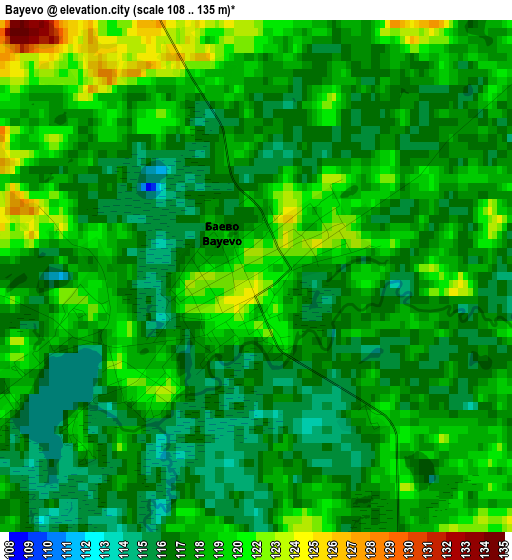
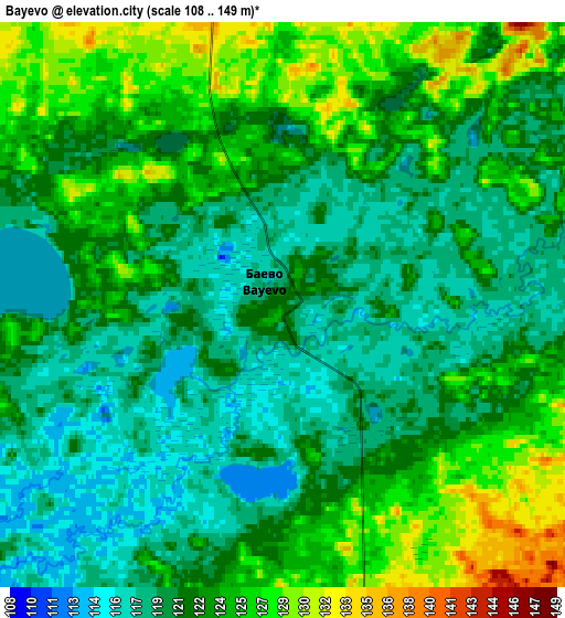
Below is the Elevation map of Bayevo, which displays elevation range with different colors. Scale of the first map is from 108 to 135 m (354 to 443 ft) with average elevation of 118.5 meters (=389 ft) [note 1]
These maps also provides idea of topography and contour of this city, they are displayed at different zoom levels. More info about maps, scale and edge coordinates you can find below images.
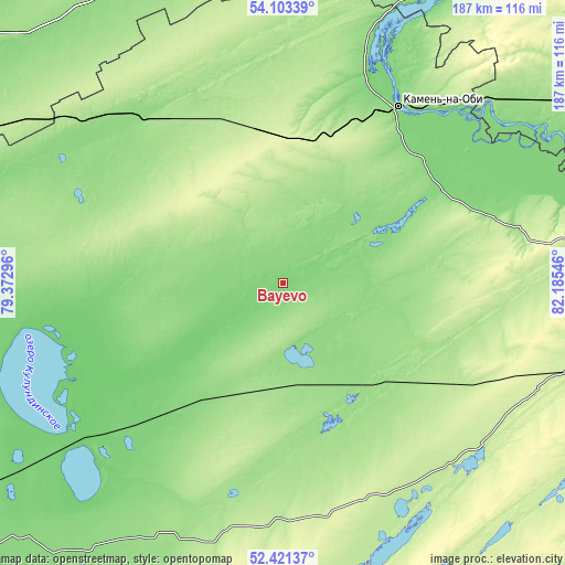
| \ | Map #1 | Map #2 | Topo.Map |
| Scale [m] | 108..135 m | 108..149 m | × |
| Scale [ft] | 354..443 ft | 354..489 ft | × |
| Average | 118.5 m = 389 ft | 122.1 m = 401 ft | × |
| Width | 5.84 km = 3.6 mi | 11.69 km = 7.3 mi | 187 km = 116.2 mi |
| Height | 5.84 km = 3.6 mi | 11.69 km = 7.3 mi | 187 km = 116.2 mi |
| ↑Max Latitude | 53.296923° | 53.323179° | 54.10339° |
| Latitude at center | 53.27065° | 53.27065° | 53.27065° |
| ↓Min Latitude | 53.244361° | 53.218056° | 52.42137° |
| ← Min Longitude | 80.735265° | 80.691319° | 79.37296° |
| Longitude center | 80.77921° | 80.77921° | 80.77921° |
| →Max Longitude | 80.823155° | 80.867101° | 82.18546° |
Nearby cities:
Cities around Bayevo sort by population:
• Kamen’-na-Obi elevation 125 m
68.5 km,  32°
32°
• Blagoveshchenka 109 m
78 km,  231°
231°
• Rodino 162 m
94.2 km,  204°
204°
• Zav’yalovo 156 m
49 km,  168°
168°
• Mamontovo 212 m
84.6 km,  138°
138°
• Romanovo 224 m
78.5 km,  157°
157°
• Khabary 138 m
91.4 km,  295°
295°
• Tyumentsevo 159 m
48.1 km,  83°
83°
• Pervomayskiy 226 m
70.9 km,  123°
123°
• Pankrushikha 164 m
68.8 km,  335°
335°
• Krutikha 125 m
81.7 km,  20°
20°
• Verkh-Suetka 138 m
48.8 km,  274°
274°
Multilingual:
 En español:
Bayevo elevación 121 m.
 En France:
Bayevo élévation 121 m.


Sources and notes:
- [note 1] Map square and city borders are not equal. Map elevation data is calculated only from area inside that square.
- [src 1] Elevation data from geonames database provided with same terms of usage.
- [src 2] The elevation map of Bayevo is generated using elevation data from NASA's 3 arcsec (90m) resolution SRTM data.
- [src 3] Base (background) map © OpenStreetMap contributors tiles are generated by Geofabrik and OpenTopoMap.
Copyright & License:
This Bayevo Elevation Map is licensed under CC BY-SA. You may reuse any part from this page, if you give a proper credit by linking to this URL:
 More info on terms of use page.