Verkhnyaya Salda elevation
Verkhnyaya Salda (Sverdlovsk), Russia elevation is 201 meters and Verkhnyaya Salda elevation in feet is 659 ft above sea level [src 1]. Verkhnyaya Salda is a populated place (feature code) with elevation that is 2 meters (7 ft) bigger than average city elevation in Russia.
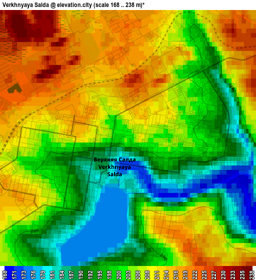
Below is the Elevation map of Verkhnyaya Salda, which displays elevation range with different colors. Scale of the first map is from 168 to 238 m (551 to 781 ft) with average elevation of 203.8 meters (=669 ft) [note 1]
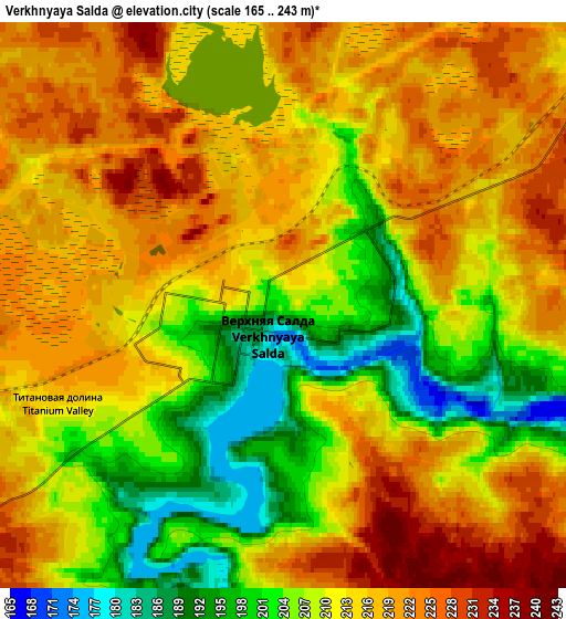
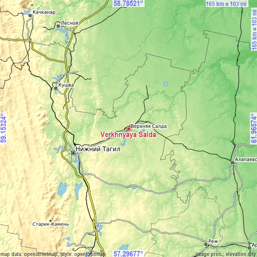
These maps also provides idea of topography and contour of this city, they are displayed at different zoom levels. More info about maps, scale and edge coordinates you can find below images.
| \ | Map #1 | Map #2 | Topo.Map |
| Scale [m] | 168..238 m | 165..243 m | × |
| Scale [ft] | 551..781 ft | 541..797 ft | × |
| Average | 203.8 m = 669 ft | 212.4 m = 697 ft | × |
| Width | 5.17 km = 3.2 mi | 10.34 km = 6.4 mi | 165.5 km = 102.8 mi |
| Height | 5.17 km = 3.2 mi | 10.34 km = 6.4 mi | 165.5 km = 102.8 mi |
| ↑Max Latitude | 58.071988° | 58.095221° | 58.78521° |
| Latitude at center | 58.04874° | 58.04874° | 58.04874° |
| ↓Min Latitude | 58.025477° | 58.002198° | 57.29677° |
| ← Min Longitude | 60.515545° | 60.471599° | 59.15324° |
| Longitude center | 60.55949° | 60.55949° | 60.55949° |
| →Max Longitude | 60.603435° | 60.647381° | 61.96574° |
Nearby cities:
Cities around Verkhnyaya Salda sort by population:
• Nizhny Tagil elevation 185 m
37.9 km,  247°
247°
• Kushva 301 m
54.1 km,  299°
299°
• Krasnoural’sk 221 m
46.4 km,  319°
319°
• Nizhnyaya Salda 167 m
10 km,  71°
71°
• Baranchinskiy 221 m
52.1 km,  283°
283°
• Verkhnyaya Tura 212 m
56.1 km,  308°
308°
• Svobodnyy 223 m
9.7 km,  264°
264°
• Nikolo-Pavlovskoye 209 m
41.8 km,  225°
225°
• Petrokamenskoye 202 m
37.4 km,  171°
171°
• Chernoistochinsk 221 m
53.5 km, 229°
• Neyvo-Shaytanskiy 182 m
54.1 km,  131°
131°
• Novoasbest 274 m
37.7 km,  205°
205°
Multilingual:
 En español:
Verkhnyaya Salda elevación 201 m.
 En France:
Verkhniaïa Salda élévation 201 m.
 Auf Deutsch:
Werchnjaja Salda höhe über dem Meeresspiegel ist 201 m.

Sources and notes:
- [note 1] Map square and city borders are not equal. Map elevation data is calculated only from area inside that square.
- [src 1] Elevation data from geonames database provided with same terms of usage.
- [src 2] The elevation map of Verkhnyaya Salda is generated using elevation data from NASA's 3 arcsec (90m) resolution SRTM data.
- [src 3] Base (background) map © OpenStreetMap contributors tiles are generated by Geofabrik and OpenTopoMap.
Copyright & License:
This Verkhnyaya Salda Elevation Map is licensed under CC BY-SA. You may reuse any part from this page, if you give a proper credit by linking to this URL:
 More info on terms of use page.