Nizhny Tagil elevation
Nizhny Tagil (Sverdlovsk), Russia elevation is 185 meters and Nizhny Tagil elevation in feet is 607 ft above sea level [src 1]. Nizhny Tagil is a populated place (feature code) with elevation that is 14 meters (46 ft) smaller than average city elevation in Russia.
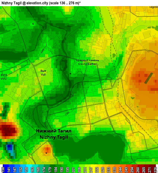
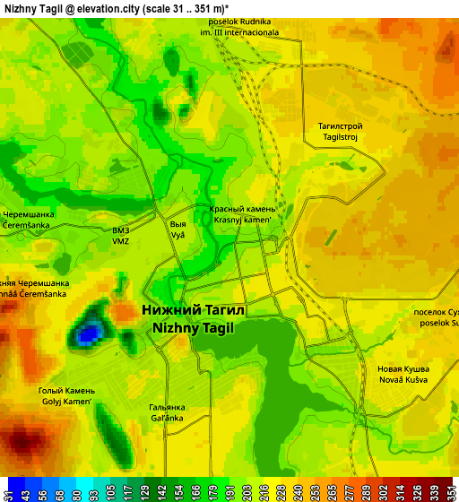
Below is the Elevation map of Nizhny Tagil, which displays elevation range with different colors. Scale of the first map is from 136 to 276 m (446 to 906 ft) with average elevation of 206.8 meters (=678 ft) [note 1]
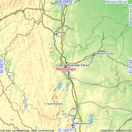
These maps also provides idea of topography and contour of this city, they are displayed at different zoom levels. More info about maps, scale and edge coordinates you can find below images.
| \ | Map #1 | Map #2 | Topo.Map |
| Scale [m] | 136..276 m | 31..351 m | × |
| Scale [ft] | 446..906 ft | 102..1152 ft | × |
| Average | 206.8 m = 678 ft | 217.4 m = 713 ft | × |
| Width | 5.19 km = 3.2 mi | 10.38 km = 6.4 mi | 166.1 km = 103.2 mi |
| Height | 5.19 km = 3.2 mi | 10.38 km = 6.4 mi | 166.1 km = 103.2 mi |
| ↑Max Latitude | 57.942772° | 57.966089° | 58.65858° |
| Latitude at center | 57.91944° | 57.91944° | 57.91944° |
| ↓Min Latitude | 57.896093° | 57.87273° | 57.16477° |
| ← Min Longitude | 59.921055° | 59.877109° | 58.55875° |
| Longitude center | 59.965° | 59.965° | 59.965° |
| →Max Longitude | 60.008945° | 60.052891° | 61.37125° |
Nearby cities:
Cities around Nizhny Tagil sort by population:
• Verkhnyaya Salda elevation 201 m
37.9 km,  67°
67°
• Kushva 301 m
43 km,  343°
343°
• Baranchinskiy 221 m
31.2 km,  329°
329°
• Svobodnyy 223 m
28.7 km,  62°
62°
• Nikolo-Pavlovskoye 209 m
16.1 km,  160°
160°
• Petrokamenskoye 202 m
46.4 km,  119°
119°
• Chernoistochinsk 221 m
21.1 km,  195°
195°
• Levikha 292 m
37.5 km,  185°
185°
• Novoasbest 274 m
27.4 km,  135°
135°
• Visim 295 m
40.8 km,  222°
222°
• Uralets 395 m
34.2 km,  213°
213°
• Karpushikha 282 m
46.6 km, 185°
Multilingual:
 En español:
Nizhny Tagil elevación 185 m.
 En France:
Nizhny Tagil élévation 185 m.
 Auf Deutsch:
Nizhny Tagil höhe über dem Meeresspiegel ist 185 m.

Sources and notes:
- [note 1] Map square and city borders are not equal. Map elevation data is calculated only from area inside that square.
- [src 1] Elevation data from geonames database provided with same terms of usage.
- [src 2] The elevation map of Nizhny Tagil is generated using elevation data from NASA's 3 arcsec (90m) resolution SRTM data.
- [src 3] Base (background) map © OpenStreetMap contributors tiles are generated by Geofabrik and OpenTopoMap.
Copyright & License:
This Nizhny Tagil Elevation Map is licensed under CC BY-SA. You may reuse any part from this page, if you give a proper credit by linking to this URL:
 More info on terms of use page.