Besleneyevskaya elevation
Besleneyevskaya (Krasnodarskiy), Russia elevation is 491 meters and Besleneyevskaya elevation in feet is 1611 ft above sea level [src 1]. Besleneyevskaya is a populated place (feature code) with elevation that is 292 meters (958 ft) bigger than average city elevation in Russia.
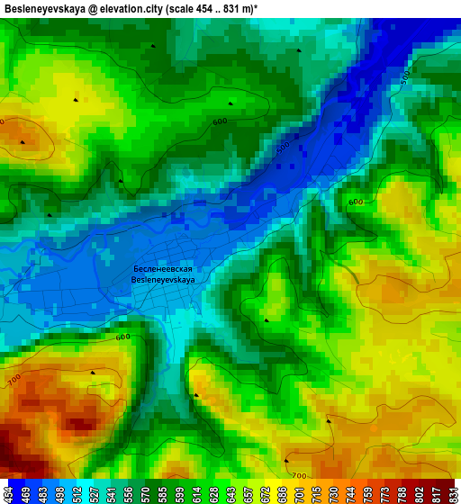
Below is the Elevation map of Besleneyevskaya, which displays elevation range with different colors. Scale of the first map is from 454 to 831 m (1490 to 2726 ft) with average elevation of 601.7 meters (=1974 ft) [note 1]
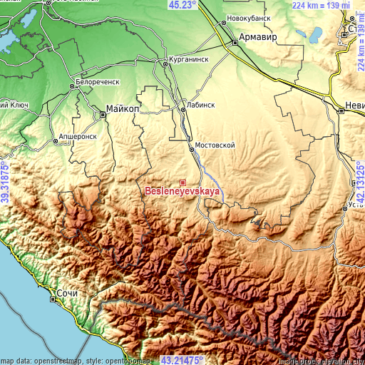
These maps also provides idea of topography and contour of this city, they are displayed at different zoom levels. More info about maps, scale and edge coordinates you can find below images.
| \ | Map #1 | Topo.Map |
| Scale [m] | 454..831 m | × |
| Scale [ft] | 1490..2726 ft | × |
| Average | 601.7 m = 1974 ft | × |
| Width | 7 km = 4.3 mi | 224.1 km = 139.2 mi |
| Height | 7 km = 4.3 mi | 224.1 km = 139.2 mi |
| ↑Max Latitude | 44.26248° | 45.23° |
| Latitude at center | 44.231° | 44.231° |
| ↓Min Latitude | 44.199503° | 43.21475° |
| ← Min Longitude | 40.681055° | 39.31875° |
| Longitude center | 40.725° | 40.725° |
| →Max Longitude | 40.768945° | 42.13125° |
Nearby cities:
Cities around Besleneyevskaya sort by population:
• Mostovskoy elevation 380 m
20.9 km,  15°
15°
• Psebay 613 m
13.8 km,  150°
150°
• Kamennomostskiy 453 m
43.2 km,  278°
278°
• Vladimirskaya 316 m
35.4 km,  8°
8°
• Voznesenskaya 385 m
43.3 km,  34°
34°
• Kurdzhinovo 810 m
32.6 km, 145°
• Abadzekhskaya 350 m
44 km,  294°
294°
• Upornaya 475 m
29.5 km,  52°
52°
• Perepravnaya 414 m
12.7 km, 22°
• Gubskaya 466 m
11.9 km,  323°
323°
• Shedok 528 m
10 km,  98°
98°
• Khodz’ 321 m
31.1 km,  358°
358°
Multilingual:
 En español:
Besleneyevskaya elevación 491 m.
 En France:
Besleneyevskaya élévation 491 m.
 Auf Deutsch:
Besleneyevskaya höhe über dem Meeresspiegel ist 491 m.

Sources and notes:
- [note 1] Map square and city borders are not equal. Map elevation data is calculated only from area inside that square.
- [src 1] Elevation data from geonames database provided with same terms of usage.
- [src 2] The elevation map of Besleneyevskaya is generated using elevation data from NASA's 3 arcsec (90m) resolution SRTM data.
- [src 3] Base (background) map © OpenStreetMap contributors tiles are generated by Geofabrik and OpenTopoMap.
Copyright & License:
This Besleneyevskaya Elevation Map is licensed under CC BY-SA. You may reuse any part from this page, if you give a proper credit by linking to this URL:
 More info on terms of use page.