Psebay elevation
Psebay (Krasnodarskiy), Russia elevation is 613 meters and Psebay elevation in feet is 2011 ft above sea level [src 1]. Psebay is a populated place (feature code) with elevation that is 414 meters (1358 ft) bigger than average city elevation in Russia.
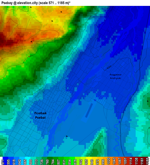
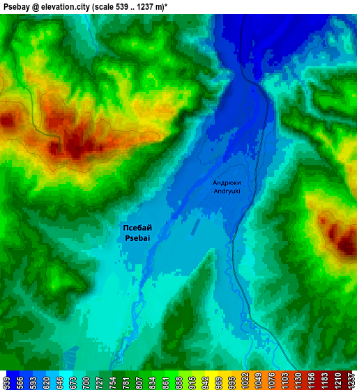
Below is the Elevation map of Psebay, which displays elevation range with different colors. Scale of the first map is from 571 to 1185 m (1873 to 3888 ft) with average elevation of 703.1 meters (=2307 ft) [note 1]
These maps also provides idea of topography and contour of this city, they are displayed at different zoom levels. More info about maps, scale and edge coordinates you can find below images.
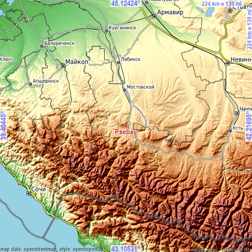
| \ | Map #1 | Map #2 | Topo.Map |
| Scale [m] | 571..1185 m | 539..1237 m | × |
| Scale [ft] | 1873..3888 ft | 1768..4058 ft | × |
| Average | 703.1 m = 2307 ft | 754.2 m = 2474 ft | × |
| Width | 7.02 km = 4.4 mi | 14.03 km = 8.7 mi | 224.5 km = 139.5 mi |
| Height | 7.02 km = 4.4 mi | 14.03 km = 8.7 mi | 224.5 km = 139.5 mi |
| ↑Max Latitude | 44.154937° | 44.186458° | 45.12424° |
| Latitude at center | 44.1234° | 44.1234° | 44.1234° |
| ↓Min Latitude | 44.091846° | 44.060275° | 43.10531° |
| ← Min Longitude | 40.766755° | 40.722809° | 39.40445° |
| Longitude center | 40.8107° | 40.8107° | 40.8107° |
| →Max Longitude | 40.854645° | 40.898591° | 42.21695° |
Nearby cities:
Cities around Psebay sort by population:
• Mostovskoy elevation 380 m
32.1 km,  357°
357°
• Vladimirskaya 316 m
47 km, 358°
• Pregradnaya 810 m
35.6 km,  121°
121°
• Spokoynaya 565 m
49.1 km,  73°
73°
• Mednogorskiy 868 m
37.5 km,  127°
127°
• Kurdzhinovo 810 m
18.9 km,  142°
142°
• Upornaya 475 m
34.1 km,  29°
29°
• Perepravnaya 414 m
23.8 km, 355°
• Gubskaya 466 m
25.6 km,  327°
327°
• Shedok 528 m
10.9 km,  16°
16°
• Khodz’ 321 m
43.7 km,  349°
349°
• Besleneyevskaya 491 m
13.8 km, 330°
Multilingual:
 En español:
Psebay elevación 613 m.
 En France:
Psebay élévation 613 m.


Sources and notes:
- [note 1] Map square and city borders are not equal. Map elevation data is calculated only from area inside that square.
- [src 1] Elevation data from geonames database provided with same terms of usage.
- [src 2] The elevation map of Psebay is generated using elevation data from NASA's 3 arcsec (90m) resolution SRTM data.
- [src 3] Base (background) map © OpenStreetMap contributors tiles are generated by Geofabrik and OpenTopoMap.
Copyright & License:
This Psebay Elevation Map is licensed under CC BY-SA. You may reuse any part from this page, if you give a proper credit by linking to this URL:
 More info on terms of use page.