Chirkey elevation
Chirkey (Dagestan), Russia elevation is 381 meters and Chirkey elevation in feet is 1250 ft above sea level [src 1]. Chirkey is a populated place (feature code) with elevation that is 182 meters (597 ft) bigger than average city elevation in Russia.
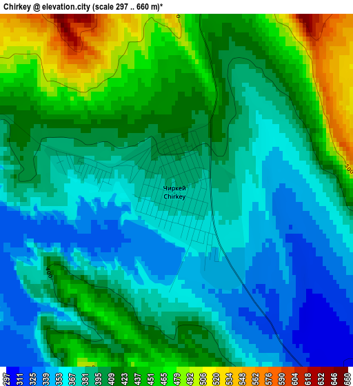
Below is the Elevation map of Chirkey, which displays elevation range with different colors. Scale of the first map is from 297 to 660 m (974 to 2165 ft) with average elevation of 402.1 meters (=1319 ft) [note 1]
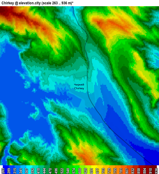
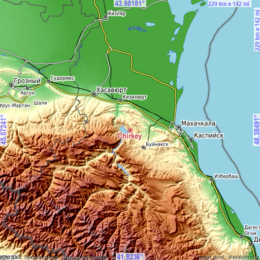
These maps also provides idea of topography and contour of this city, they are displayed at different zoom levels. More info about maps, scale and edge coordinates you can find below images.
| \ | Map #1 | Map #2 | Topo.Map |
| Scale [m] | 297..660 m | 263..936 m | × |
| Scale [ft] | 974..2165 ft | 863..3071 ft | × |
| Average | 402.1 m = 1319 ft | 465.8 m = 1528 ft | × |
| Width | 7.15 km = 4.4 mi | 14.3 km = 8.9 mi | 228.9 km = 142.2 mi |
| Height | 7.15 km = 4.4 mi | 14.3 km = 8.9 mi | 228.8 km = 142.2 mi |
| ↑Max Latitude | 42.993461° | 43.025596° | 43.98181° |
| Latitude at center | 42.96131° | 42.96131° | 42.96131° |
| ↓Min Latitude | 42.929142° | 42.896957° | 41.9236° |
| ← Min Longitude | 46.934715° | 46.890769° | 45.57241° |
| Longitude center | 46.97866° | 46.97866° | 46.97866° |
| →Max Longitude | 47.022605° | 47.066551° | 48.38491° |
Nearby cities:
Cities around Chirkey sort by population:
• Buynaksk elevation 475 m
19.5 km,  144°
144°
• Kizilyurt 70 m
26.4 km,  343°
343°
• Nizhneye Kazanishche 575 m
26.5 km,  146°
146°
• Novyy Chirkey 20 m
23.2 km,  15°
15°
• Korkmaskala 58 m
26.6 km,  74°
74°
• Dubki 848 m
13.3 km,  300°
300°
• Bavtugay 105 m
25.8 km,  332°
332°
• Miatli 153 m
18.1 km,  317°
317°
• Kafyr-Kumukh 368 m
19.8 km,  133°
133°
• Erpeli 778 m
17.3 km,  180°
180°
• Gimry 495 m
25.1 km,  206°
206°
• Uchkent 123 m
19 km,  26°
26°
Multilingual:
 En español:
Chirkey elevación 381 m.
 En France:
Chirkey élévation 381 m.


Sources and notes:
- [note 1] Map square and city borders are not equal. Map elevation data is calculated only from area inside that square.
- [src 1] Elevation data from geonames database provided with same terms of usage.
- [src 2] The elevation map of Chirkey is generated using elevation data from NASA's 3 arcsec (90m) resolution SRTM data.
- [src 3] Base (background) map © OpenStreetMap contributors tiles are generated by Geofabrik and OpenTopoMap.
Copyright & License:
This Chirkey Elevation Map is licensed under CC BY-SA. You may reuse any part from this page, if you give a proper credit by linking to this URL:
 More info on terms of use page.