Kafyr-Kumukh elevation
Kafyr-Kumukh (Dagestan), Russia elevation is 368 meters and Kafyr-Kumukh elevation in feet is 1207 ft above sea level [src 1]. Kafyr-Kumukh is a populated place (feature code) with elevation that is 169 meters (554 ft) bigger than average city elevation in Russia.
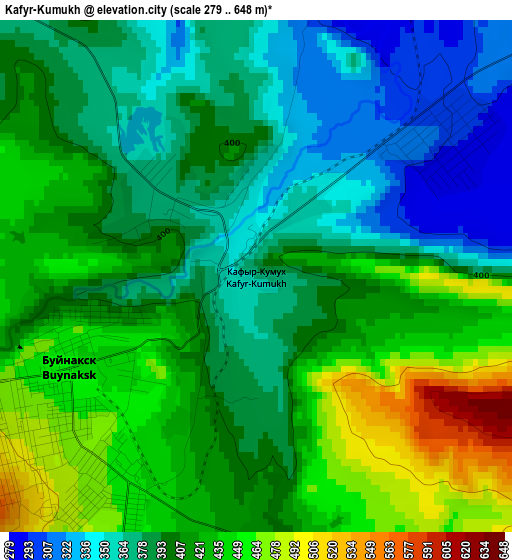
Below is the Elevation map of Kafyr-Kumukh, which displays elevation range with different colors. Scale of the first map is from 279 to 648 m (915 to 2126 ft) with average elevation of 404.6 meters (=1327 ft) [note 1]
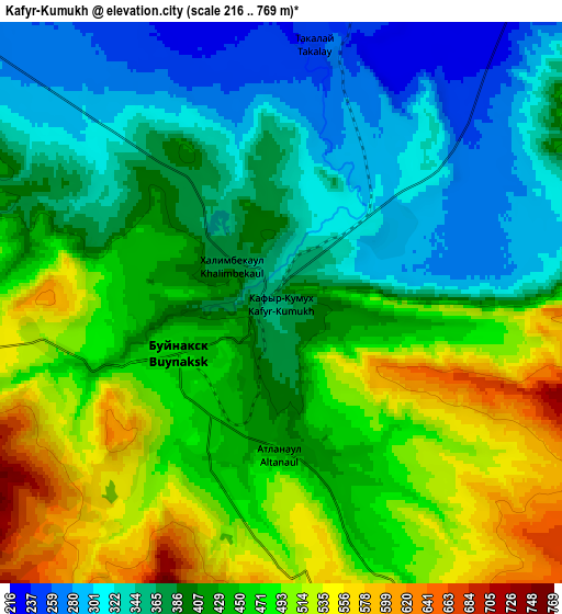
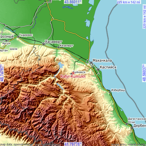
These maps also provides idea of topography and contour of this city, they are displayed at different zoom levels. More info about maps, scale and edge coordinates you can find below images.
| \ | Map #1 | Map #2 | Topo.Map |
| Scale [m] | 279..648 m | 216..769 m | × |
| Scale [ft] | 915..2126 ft | 709..2523 ft | × |
| Average | 404.6 m = 1327 ft | 422.7 m = 1387 ft | × |
| Width | 7.17 km = 4.5 mi | 14.33 km = 8.9 mi | 229.3 km = 142.5 mi |
| Height | 7.17 km = 4.5 mi | 14.33 km = 8.9 mi | 229.3 km = 142.5 mi |
| ↑Max Latitude | 42.869756° | 42.901955° | 43.86011° |
| Latitude at center | 42.83754° | 42.83754° | 42.83754° |
| ↓Min Latitude | 42.805307° | 42.773058° | 41.79776° |
| ← Min Longitude | 47.110175° | 47.066229° | 45.74787° |
| Longitude center | 47.15412° | 47.15412° | 47.15412° |
| →Max Longitude | 47.198065° | 47.242011° | 48.56037° |
Nearby cities:
Cities around Kafyr-Kumukh sort by population:
• Buynaksk elevation 475 m
3.5 km,  234°
234°
• Leninkent 112 m
21.8 km,  47°
47°
• Nizhneye Kazanishche 575 m
8.2 km,  176°
176°
• Chirkey 381 m
19.8 km,  313°
313°
• Nizhniy Dzhengutay 626 m
17 km,  154°
154°
• Verkhneye Kazanishche 709 m
11.4 km,  186°
186°
• Korkmaskala 58 m
23.6 km,  28°
28°
• Shamkhal-Termen 34 m
25.3 km, 30°
• Dorgeli 657 m
22.2 km, 148°
• Paraul 416 m
19.6 km,  122°
122°
• Karamakhi 1075 m
25.8 km,  160°
160°
• Erpeli 778 m
14.8 km,  256°
256°
Multilingual:
 En español:
Kafyr-Kumukh elevación 368 m.
 En France:
Kafyr-Kumukh élévation 368 m.
 Auf Deutsch:
Kafyr-Kumukh höhe über dem Meeresspiegel ist 368 m.

Sources and notes:
- [note 1] Map square and city borders are not equal. Map elevation data is calculated only from area inside that square.
- [src 1] Elevation data from geonames database provided with same terms of usage.
- [src 2] The elevation map of Kafyr-Kumukh is generated using elevation data from NASA's 3 arcsec (90m) resolution SRTM data.
- [src 3] Base (background) map © OpenStreetMap contributors tiles are generated by Geofabrik and OpenTopoMap.
Copyright & License:
This Kafyr-Kumukh Elevation Map is licensed under CC BY-SA. You may reuse any part from this page, if you give a proper credit by linking to this URL:
 More info on terms of use page.