Dorgeli elevation
Dorgeli (Dagestan), Russia elevation is 657 meters and Dorgeli elevation in feet is 2156 ft above sea level [src 1]. Dorgeli is a populated place (feature code) with elevation that is 458 meters (1503 ft) bigger than average city elevation in Russia.
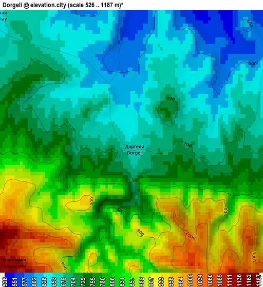
Below is the Elevation map of Dorgeli, which displays elevation range with different colors. Scale of the first map is from 526 to 1187 m (1726 to 3894 ft) with average elevation of 756.3 meters (=2481 ft) [note 1]
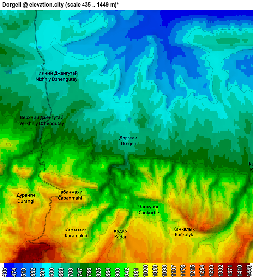
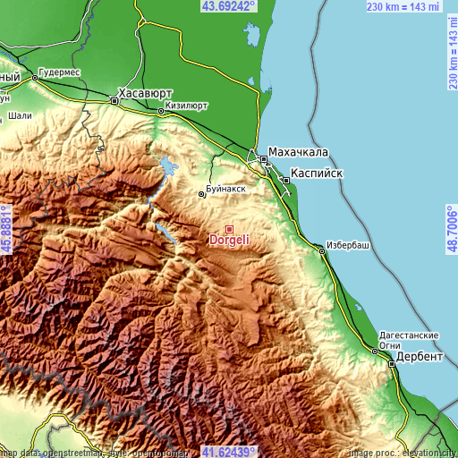
These maps also provides idea of topography and contour of this city, they are displayed at different zoom levels. More info about maps, scale and edge coordinates you can find below images.
| \ | Map #1 | Map #2 | Topo.Map |
| Scale [m] | 526..1187 m | 435..1449 m | × |
| Scale [ft] | 1726..3894 ft | 1427..4754 ft | × |
| Average | 756.3 m = 2481 ft | 800.9 m = 2628 ft | × |
| Width | 7.19 km = 4.5 mi | 14.37 km = 8.9 mi | 229.9 km = 142.9 mi |
| Height | 7.19 km = 4.5 mi | 14.37 km = 8.9 mi | 229.9 km = 142.9 mi |
| ↑Max Latitude | 42.699305° | 42.731593° | 43.69242° |
| Latitude at center | 42.667° | 42.667° | 42.667° |
| ↓Min Latitude | 42.634678° | 42.60234° | 41.62439° |
| ← Min Longitude | 47.250405° | 47.206459° | 45.8881° |
| Longitude center | 47.29435° | 47.29435° | 47.29435° |
| →Max Longitude | 47.338295° | 47.382241° | 48.7006° |
Nearby cities:
Cities around Dorgeli sort by population:
• Buynaksk elevation 475 m
22.1 km,  319°
319°
• Karabudakhkent 192 m
22.8 km,  78°
78°
• Nizhneye Kazanishche 575 m
15.3 km,  314°
314°
• Gubden 589 m
24.8 km,  116°
116°
• Nizhniy Dzhengutay 626 m
5.5 km, 312°
• Verkhneye Kazanishche 709 m
14.9 km,  300°
300°
• Gergebil’ 729 m
26 km,  225°
225°
• Gurbuki 434 m
25.8 km,  103°
103°
• Paraul 416 m
9.7 km,  30°
30°
• Kafyr-Kumukh 368 m
22.2 km,  328°
328°
• Karamakhi 1075 m
6 km,  207°
207°
• Urma 1201 m
14.3 km,  182°
182°
Multilingual:
 En español:
Dorgeli elevación 657 m.
 En France:
Dorgeli élévation 657 m.


Sources and notes:
- [note 1] Map square and city borders are not equal. Map elevation data is calculated only from area inside that square.
- [src 1] Elevation data from geonames database provided with same terms of usage.
- [src 2] The elevation map of Dorgeli is generated using elevation data from NASA's 3 arcsec (90m) resolution SRTM data.
- [src 3] Base (background) map © OpenStreetMap contributors tiles are generated by Geofabrik and OpenTopoMap.
Copyright & License:
This Dorgeli Elevation Map is licensed under CC BY-SA. You may reuse any part from this page, if you give a proper credit by linking to this URL:
 More info on terms of use page.