Gurbuki elevation
Gurbuki (Dagestan), Russia elevation is 434 meters and Gurbuki elevation in feet is 1424 ft above sea level [src 1]. Gurbuki is a populated place (feature code) with elevation that is 235 meters (771 ft) bigger than average city elevation in Russia.
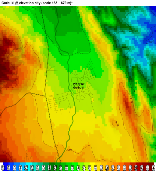
Below is the Elevation map of Gurbuki, which displays elevation range with different colors. Scale of the first map is from 163 to 679 m (535 to 2228 ft) with average elevation of 451.7 meters (=1482 ft) [note 1]
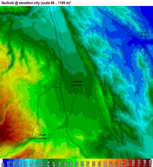
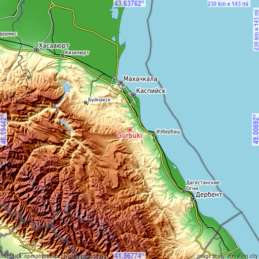
These maps also provides idea of topography and contour of this city, they are displayed at different zoom levels. More info about maps, scale and edge coordinates you can find below images.
| \ | Map #1 | Map #2 | Topo.Map |
| Scale [m] | 163..679 m | 69..1189 m | × |
| Scale [ft] | 535..2228 ft | 226..3901 ft | × |
| Average | 451.7 m = 1482 ft | 453.5 m = 1488 ft | × |
| Width | 7.19 km = 4.5 mi | 14.38 km = 8.9 mi | 230.1 km = 143 mi |
| Height | 7.19 km = 4.5 mi | 14.38 km = 8.9 mi | 230.1 km = 143 mi |
| ↑Max Latitude | 42.643614° | 42.675931° | 43.63762° |
| Latitude at center | 42.61128° | 42.61128° | 42.61128° |
| ↓Min Latitude | 42.578929° | 42.546562° | 41.56774° |
| ← Min Longitude | 47.556725° | 47.512779° | 46.19442° |
| Longitude center | 47.60067° | 47.60067° | 47.60067° |
| →Max Longitude | 47.644615° | 47.688561° | 49.00692° |
Nearby cities:
Cities around Gurbuki sort by population:
• Izberbash elevation -5 m
22.1 km,  102°
102°
• Karabudakhkent 192 m
11.2 km,  345°
345°
• Sergokala 530 m
18.1 km,  164°
164°
• Gubden 589 m
5.6 km,  210°
210°
• Manas 56 m
14.4 km,  26°
26°
• Dorgeli 657 m
25.8 km,  283°
283°
• Manaskent 37 m
16.1 km, 27°
• Myurego 502 m
23.5 km, 161°
• Paraul 416 m
24.8 km,  305°
305°
• Utamysh 327 m
25.8 km,  151°
151°
• Ullubiyaul 161 m
9.8 km, 99°
• Achisu 183 m
8.1 km,  56°
56°
Multilingual:
 En español:
Gurbuki elevación 434 m.
 En France:
Gurbuki élévation 434 m.


Sources and notes:
- [note 1] Map square and city borders are not equal. Map elevation data is calculated only from area inside that square.
- [src 1] Elevation data from geonames database provided with same terms of usage.
- [src 2] The elevation map of Gurbuki is generated using elevation data from NASA's 3 arcsec (90m) resolution SRTM data.
- [src 3] Base (background) map © OpenStreetMap contributors tiles are generated by Geofabrik and OpenTopoMap.
Copyright & License:
This Gurbuki Elevation Map is licensed under CC BY-SA. You may reuse any part from this page, if you give a proper credit by linking to this URL:
 More info on terms of use page.