Manaskent elevation
Manaskent (Dagestan), Russia elevation is 37 meters and Manaskent elevation in feet is 121 ft above sea level [src 1]. Manaskent is a populated place (feature code) with elevation that is 162 meters (531 ft) smaller than average city elevation in Russia.
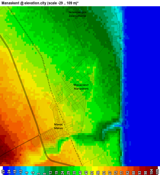
Below is the Elevation map of Manaskent, which displays elevation range with different colors. Scale of the first map is from -29 to 109 m (-95 to 358 ft) with average elevation of 25.9 meters (=85 ft) [note 1]
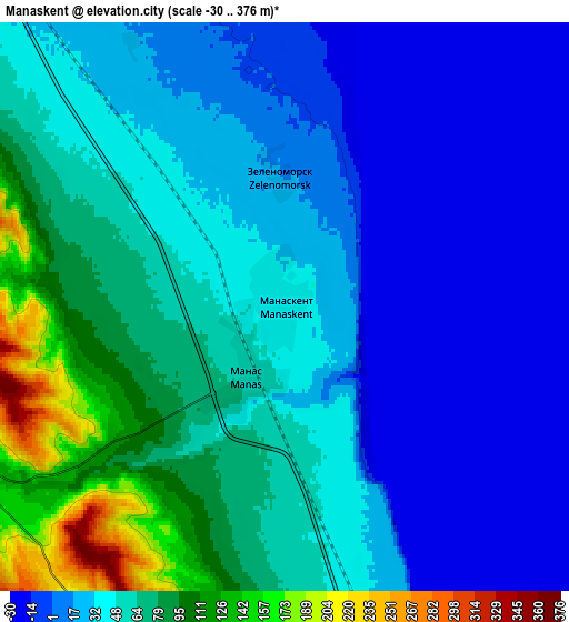
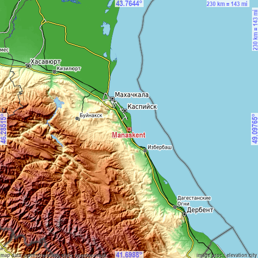
These maps also provides idea of topography and contour of this city, they are displayed at different zoom levels. More info about maps, scale and edge coordinates you can find below images.
| \ | Map #1 | Map #2 | Topo.Map |
| Scale [m] | -29..109 m | -30..376 m | × |
| Scale [ft] | -95..358 ft | -98..1234 ft | × |
| Average | 25.9 m = 85 ft | 40.1 m = 132 ft | × |
| Width | 7.18 km = 4.5 mi | 14.35 km = 8.9 mi | 229.7 km = 142.7 mi |
| Height | 7.18 km = 4.5 mi | 14.35 km = 8.9 mi | 229.7 km = 142.7 mi |
| ↑Max Latitude | 42.772467° | 42.804717° | 43.7644° |
| Latitude at center | 42.7402° | 42.7402° | 42.7402° |
| ↓Min Latitude | 42.707916° | 42.675616° | 41.6988° |
| ← Min Longitude | 47.647455° | 47.603509° | 46.28515° |
| Longitude center | 47.6914° | 47.6914° | 47.6914° |
| →Max Longitude | 47.735345° | 47.779291° | 49.09765° |
Nearby cities:
Cities around Manaskent sort by population:
• Makhachkala elevation 4 m
30.4 km,  329°
329°
• Kaspiysk -16 m
16.3 km,  344°
344°
• Izberbash -5 m
23.7 km,  143°
143°
• Karabudakhkent 192 m
10.7 km,  250°
250°
• Tarki 142 m
27.8 km,  324°
324°
• Gubden 589 m
21.7 km,  208°
208°
• Novyy Khushet 4 m
20.7 km, 328°
• Manas 56 m
1.8 km,  216°
216°
• Gurbuki 434 m
16.1 km, 207°
• Paraul 416 m
27.4 km,  270°
270°
• Ullubiyaul 161 m
16.1 km,  172°
172°
• Achisu 183 m
9.8 km,  184°
184°
Multilingual:
 En español:
Manaskent elevación 37 m.
 En France:
Manaskent élévation 37 m.
 Auf Deutsch:
Manaskent höhe über dem Meeresspiegel ist 37 m.

Sources and notes:
- [note 1] Map square and city borders are not equal. Map elevation data is calculated only from area inside that square.
- [src 1] Elevation data from geonames database provided with same terms of usage.
- [src 2] The elevation map of Manaskent is generated using elevation data from NASA's 3 arcsec (90m) resolution SRTM data.
- [src 3] Base (background) map © OpenStreetMap contributors tiles are generated by Geofabrik and OpenTopoMap.
Copyright & License:
This Manaskent Elevation Map is licensed under CC BY-SA. You may reuse any part from this page, if you give a proper credit by linking to this URL:
 More info on terms of use page.