Uchkent elevation
Uchkent (Dagestan), Russia elevation is 123 meters and Uchkent elevation in feet is 404 ft above sea level [src 1]. Uchkent is a populated place (feature code) with elevation that is 76 meters (249 ft) smaller than average city elevation in Russia.
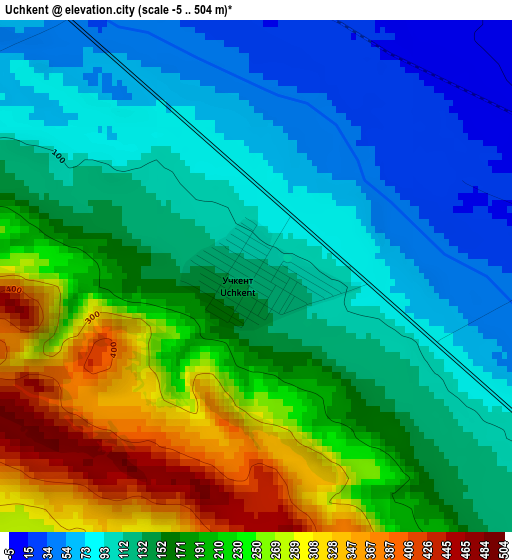
Below is the Elevation map of Uchkent, which displays elevation range with different colors. Scale of the first map is from -5 to 504 m (-16 to 1654 ft) with average elevation of 160.6 meters (=527 ft) [note 1]
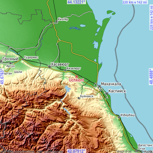
These maps also provides idea of topography and contour of this city, they are displayed at different zoom levels. More info about maps, scale and edge coordinates you can find below images.
| \ | Map #1 | Topo.Map |
| Scale [m] | -5..504 m | × |
| Scale [ft] | -16..1654 ft | × |
| Average | 160.6 m = 527 ft | × |
| Width | 7.13 km = 4.4 mi | 228.3 km = 141.9 mi |
| Height | 7.13 km = 4.4 mi | 228.3 km = 141.9 mi |
| ↑Max Latitude | 43.146341° | 44.13221° |
| Latitude at center | 43.11427° | 43.11427° |
| ↓Min Latitude | 43.082182° | 42.07912° |
| ← Min Longitude | 47.038605° | 45.6763° |
| Longitude center | 47.08255° | 47.08255° |
| →Max Longitude | 47.126495° | 48.4888° |
Nearby cities:
Cities around Uchkent sort by population:
• Kizilyurt elevation 70 m
18 km,  297°
297°
• Shamkhal 3 m
21.6 km,  106°
106°
• Chirkey 381 m
19 km,  206°
206°
• Novyy Chirkey 20 m
5.7 km,  337°
337°
• Tyube 19 m
19.6 km, 111°
• Korkmaskala 58 m
19.9 km,  120°
120°
• Shamkhal-Termen 34 m
20.6 km, 115°
• Dubki 848 m
22.4 km,  242°
242°
• Novyy Sulak 78 m
22.1 km,  289°
289°
• Bavtugay 105 m
21 km, 286°
• Zubutli-Miatli 59 m
23.8 km, 293°
• Miatli 153 m
20.9 km,  260°
260°
Multilingual:
 En español:
Uchkent elevación 123 m.
 En France:
Uchkent élévation 123 m.


Sources and notes:
- [note 1] Map square and city borders are not equal. Map elevation data is calculated only from area inside that square.
- [src 1] Elevation data from geonames database provided with same terms of usage.
- [src 2] The elevation map of Uchkent is generated using elevation data from NASA's 3 arcsec (90m) resolution SRTM data.
- [src 3] Base (background) map © OpenStreetMap contributors tiles are generated by Geofabrik and OpenTopoMap.
Copyright & License:
This Uchkent Elevation Map is licensed under CC BY-SA. You may reuse any part from this page, if you give a proper credit by linking to this URL:
 More info on terms of use page.