Dubovyy Umët elevation
Dubovyy Umët (Samara Oblast), Russia elevation is 137 meters and Dubovyy Umët elevation in feet is 449 ft above sea level [src 1]. Dubovyy Umët is a populated place (feature code) with elevation that is 62 meters (203 ft) smaller than average city elevation in Russia.
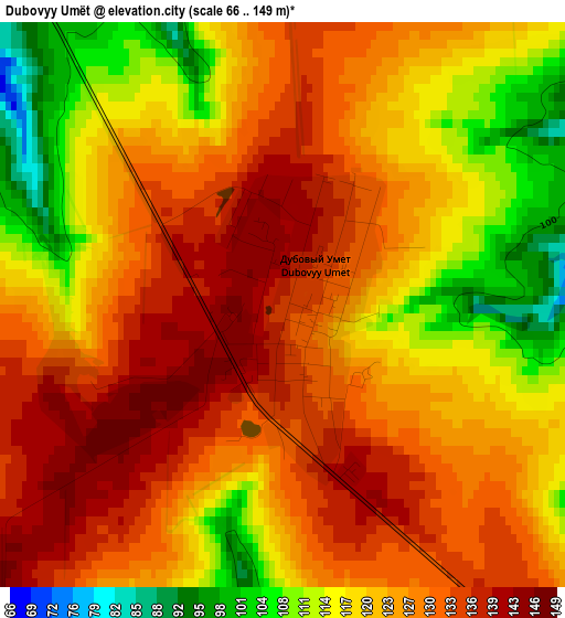
Below is the Elevation map of Dubovyy Umët, which displays elevation range with different colors. Scale of the first map is from 66 to 149 m (217 to 489 ft) with average elevation of 124.4 meters (=408 ft) [note 1]
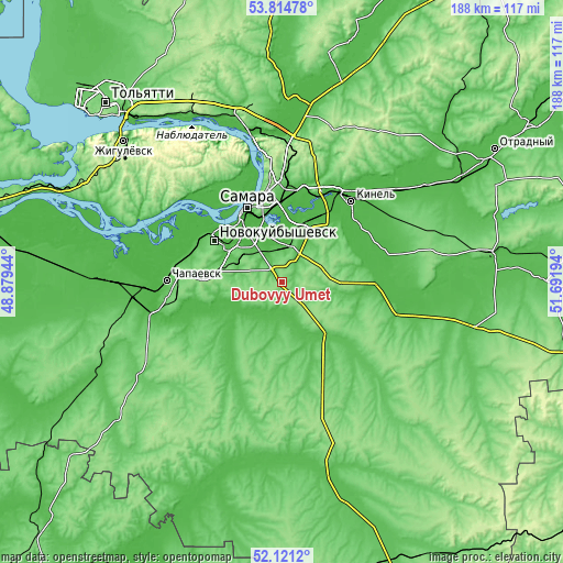
These maps also provides idea of topography and contour of this city, they are displayed at different zoom levels. More info about maps, scale and edge coordinates you can find below images.
| \ | Map #1 | Topo.Map |
| Scale [m] | 66..149 m | × |
| Scale [ft] | 217..489 ft | × |
| Average | 124.4 m = 408 ft | × |
| Width | 5.88 km = 3.7 mi | 188.3 km = 117 mi |
| Height | 5.88 km = 3.7 mi | 188.3 km = 117 mi |
| ↑Max Latitude | 53.002743° | 53.81478° |
| Latitude at center | 52.97629° | 52.97629° |
| ↓Min Latitude | 52.94982° | 52.1212° |
| ← Min Longitude | 50.241745° | 48.87944° |
| Longitude center | 50.28569° | 50.28569° |
| →Max Longitude | 50.329635° | 51.69194° |
Nearby cities:
Cities around Dubovyy Umët sort by population:
• Samara elevation 117 m
26.5 km,  339°
339°
• Novokuybyshevsk 110 m
26.3 km,  300°
300°
• Chapayevsk 39 m
38.6 km,  270°
270°
• Kinel’ 38 m
36 km,  39°
39°
• Roschinskiy 113 m
16.4 km,  59°
59°
• Novosemeykino 166 m
44.1 km,  5°
5°
• Petra-Dubrava 148 m
36 km, 8°
• Smyshlyayevka 36 m
30.1 km, 13°
• Krasnoarmeyskoye 56 m
33.2 km,  210°
210°
• Rozhdestveno 39 m
32.7 km,  332°
332°
• Utevka 43 m
45.2 km,  100°
100°
• Spiridonovka 37 m
27.3 km, 61°
Multilingual:
 En español:
Dubovyy Umët elevación 137 m.
 En France:
Dubovyy Umët élévation 137 m.
 Auf Deutsch:
Dubovyy Umët höhe über dem Meeresspiegel ist 137 m.
 На русском:
Дубовый Умет, Дубовый Умёт высота над уровнем моря 137 м
Sources and notes:
- [note 1] Map square and city borders are not equal. Map elevation data is calculated only from area inside that square.
- [src 1] Elevation data from geonames database provided with same terms of usage.
- [src 2] The elevation map of Dubovyy Umët is generated using elevation data from NASA's 3 arcsec (90m) resolution SRTM data.
- [src 3] Base (background) map © OpenStreetMap contributors tiles are generated by Geofabrik and OpenTopoMap.
Copyright & License:
This Dubovyy Umët Elevation Map is licensed under CC BY-SA. You may reuse any part from this page, if you give a proper credit by linking to this URL:
 More info on terms of use page.