Samara elevation
Samara (Samara Oblast), Russia elevation is 117 meters and Samara elevation in feet is 384 ft above sea level [src 1]. Samara is a seat of a first-order administrative division (feature code) with elevation that is 82 meters (269 ft) smaller than average city elevation in Russia.
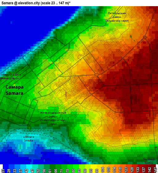
Below is the Elevation map of Samara, which displays elevation range with different colors. Scale of the first map is from 23 to 147 m (75 to 482 ft) with average elevation of 84.1 meters (=276 ft) [note 1]
These maps also provides idea of topography and contour of this city, they are displayed at different zoom levels. More info about maps, scale and edge coordinates you can find below images.
| \ | Map #1 | Map #2 | Topo.Map |
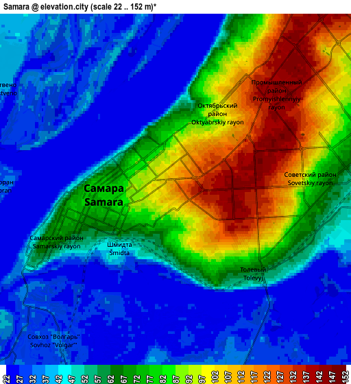
| Scale [m] | 23..147 m | 22..152 m | × |
| Scale [ft] | 75..482 ft | 72..499 ft | × |
| Average | 84.1 m = 276 ft | 59.1 m = 194 ft | × |
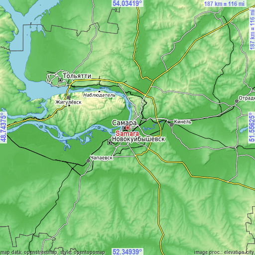
| Width | 5.85 km = 3.6 mi | 11.71 km = 7.3 mi | 187.3 km = 116.4 mi |
| Height | 5.85 km = 3.6 mi | 11.71 km = 7.3 mi | 187.3 km = 116.4 mi |
| ↑Max Latitude | 53.226386° | 53.252686° | 54.03419° |
| Latitude at center | 53.20007° | 53.20007° | 53.20007° |
| ↓Min Latitude | 53.173738° | 53.147389° | 52.34939° |
| ← Min Longitude | 50.106055° | 50.062109° | 48.74375° |
| Longitude center | 50.15° | 50.15° | 50.15° |
| →Max Longitude | 50.193945° | 50.237891° | 51.55625° |
Nearby cities:
Cities around Samara sort by population:
• Novokuybyshevsk elevation 110 m
17.9 km,  229°
229°
• Kinel’ 38 m
32 km,  84°
84°
• Roschinskiy 113 m
28.4 km,  125°
125°
• Novosemeykino 166 m
23.3 km,  35°
35°
• Mirnyy 41 m
35.1 km,  13°
13°
• Volzhskiy 47 m
25.7 km,  355°
355°
• Kurumoch 61 m
33.1 km,  346°
346°
• Petra-Dubrava 148 m
17.9 km,  53°
53°
• Smyshlyayevka 36 m
16.6 km,  74°
74°
• Rozhdestveno 39 m
7.3 km,  304°
304°
• Dubovyy Umët 137 m
26.5 km,  159°
159°
• Bogatyr’ 53 m
28.9 km,  331°
331°
Multilingual:
 En español:
Samara elevación 117 m.
 En France:
Samara élévation 117 m.


Sources and notes:
- [note 1] Map square and city borders are not equal. Map elevation data is calculated only from area inside that square.
- [src 1] Elevation data from geonames database provided with same terms of usage.
- [src 2] The elevation map of Samara is generated using elevation data from NASA's 3 arcsec (90m) resolution SRTM data.
- [src 3] Base (background) map © OpenStreetMap contributors tiles are generated by Geofabrik and OpenTopoMap.
Copyright & License:
This Samara Elevation Map is licensed under CC BY-SA. You may reuse any part from this page, if you give a proper credit by linking to this URL:
 More info on terms of use page.