Grayvoron elevation
Grayvoron (Belgorod Oblast), Russia elevation is 139 meters and Grayvoron elevation in feet is 456 ft above sea level [src 1]. Grayvoron is a seat of a second-order administrative division (feature code) with elevation that is 60 meters (197 ft) smaller than average city elevation in Russia.
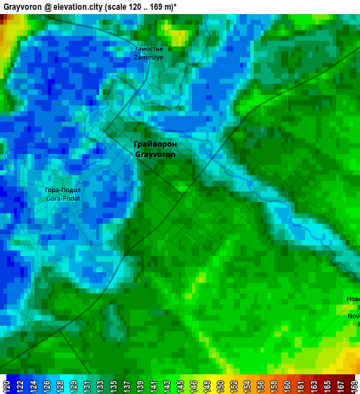
Below is the Elevation map of Grayvoron, which displays elevation range with different colors. Scale of the first map is from 120 to 169 m (394 to 554 ft) with average elevation of 134.2 meters (=440 ft) [note 1]
These maps also provides idea of topography and contour of this city, they are displayed at different zoom levels. More info about maps, scale and edge coordinates you can find below images.
| \ | Map #1 | Map #2 | Topo.Map |
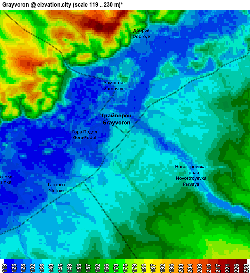
| Scale [m] | 120..169 m | 119..230 m | × |
| Scale [ft] | 394..554 ft | 390..755 ft | × |
| Average | 134.2 m = 440 ft | 147.1 m = 483 ft | × |
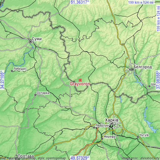
| Width | 6.22 km = 3.9 mi | 12.44 km = 7.7 mi | 199 km = 123.7 mi |
| Height | 6.22 km = 3.9 mi | 12.44 km = 7.7 mi | 199 km = 123.7 mi |
| ↑Max Latitude | 50.504658° | 50.5326° | 51.36317° |
| Latitude at center | 50.4767° | 50.4767° | 50.4767° |
| ↓Min Latitude | 50.448725° | 50.420734° | 49.57329° |
| ← Min Longitude | 35.633355° | 35.589409° | 34.27105° |
| Longitude center | 35.6773° | 35.6773° | 35.6773° |
| →Max Longitude | 35.721245° | 35.765191° | 37.08355° |
Nearby cities:
Cities around Grayvoron sort by population:
• Belgorod elevation 173 m
65.5 km,  76°
76°
• Stroitel’ 240 m
66.4 km,  58°
58°
• Borisovka 140 m
27.6 km, 59°
• Rakitnoye 193 m
42.1 km,  16°
16°
• Proletarskiy 216 m
35.6 km,  10°
10°
• Krasnaya Yaruga 207 m
36.1 km,  357°
357°
• Tomarovka 151 m
45.5 km, 59°
• Severnyy 211 m
65.7 km,  70°
70°
• Mayskiy 180 m
55.5 km,  85°
85°
• Golovchino 140 m
10.6 km,  52°
52°
• Bessonovka 201 m
44.5 km, 82°
• Belaya 152 m
64.3 km,  2°
2°
Multilingual:
 En español:
Grayvoron elevación 139 m.
 En France:
Grayvoron élévation 139 m.
 Auf Deutsch:
Grayvoron höhe über dem Meeresspiegel ist 139 m.

Sources and notes:
- [note 1] Map square and city borders are not equal. Map elevation data is calculated only from area inside that square.
- [src 1] Elevation data from geonames database provided with same terms of usage.
- [src 2] The elevation map of Grayvoron is generated using elevation data from NASA's 3 arcsec (90m) resolution SRTM data.
- [src 3] Base (background) map © OpenStreetMap contributors tiles are generated by Geofabrik and OpenTopoMap.
Copyright & License:
This Grayvoron Elevation Map is licensed under CC BY-SA. You may reuse any part from this page, if you give a proper credit by linking to this URL:
 More info on terms of use page.