Kil’mez’ elevation
Kil’mez’ (Kirov), Russia elevation is 122 meters and Kil’mez’ elevation in feet is 400 ft above sea level [src 1]. Kil’mez’ is a populated place (feature code) with elevation that is 77 meters (253 ft) smaller than average city elevation in Russia.
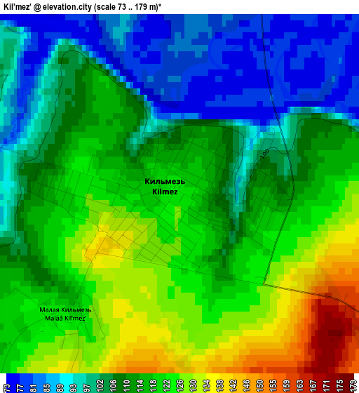
Below is the Elevation map of Kil’mez’, which displays elevation range with different colors. Scale of the first map is from 73 to 179 m (240 to 587 ft) with average elevation of 112.1 meters (=368 ft) [note 1]
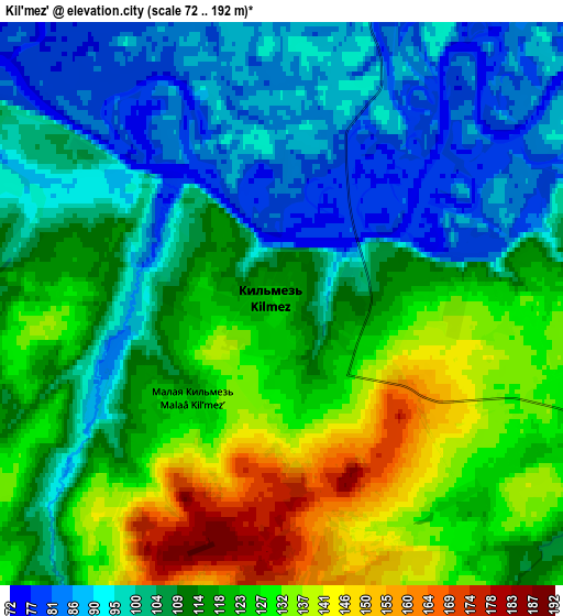
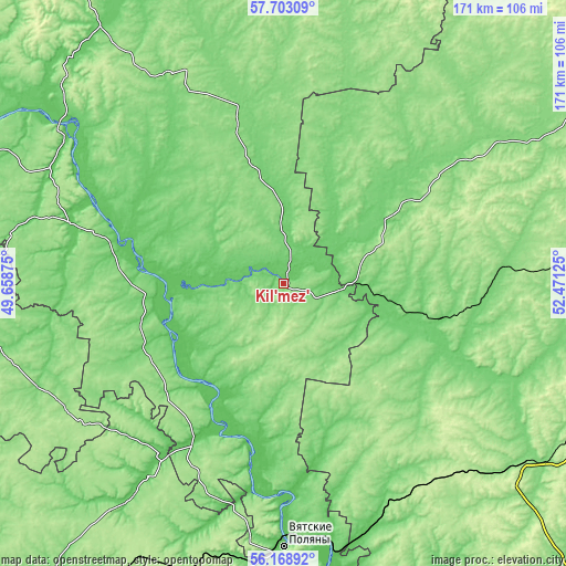
These maps also provides idea of topography and contour of this city, they are displayed at different zoom levels. More info about maps, scale and edge coordinates you can find below images.
| \ | Map #1 | Map #2 | Topo.Map |
| Scale [m] | 73..179 m | 72..192 m | × |
| Scale [ft] | 240..587 ft | 236..630 ft | × |
| Average | 112.1 m = 368 ft | 112.8 m = 370 ft | × |
| Width | 5.33 km = 3.3 mi | 10.66 km = 6.6 mi | 170.6 km = 106 mi |
| Height | 5.33 km = 3.3 mi | 10.66 km = 6.6 mi | 170.6 km = 106 mi |
| ↑Max Latitude | 56.967853° | 56.9918° | 57.70309° |
| Latitude at center | 56.94389° | 56.94389° | 56.94389° |
| ↓Min Latitude | 56.919912° | 56.895918° | 56.16892° |
| ← Min Longitude | 51.021055° | 50.977109° | 49.65875° |
| Longitude center | 51.065° | 51.065° | 51.065° |
| →Max Longitude | 51.108945° | 51.152891° | 52.47125° |
Nearby cities:
Cities around Kil’mez’ sort by population:
• Uva elevation 120 m
68.1 km,  85°
85°
• Sosnovka 91 m
77.8 km,  170°
170°
• Urzhum 104 m
67.2 km,  286°
286°
• Kizner 76 m
79.2 km,  159°
159°
• Malmyzh 76 m
52.6 km,  206°
206°
• Krasnaya Polyana 65 m
78.2 km,  176°
176°
• Syumsi 99 m
38.1 km,  60°
60°
• Vavozh 137 m
55.9 km,  109°
109°
• Selty 138 m
76.5 km, 57°
• Nema 153 m
71.2 km,  331°
331°
• Arkul’ 75 m
72.1 km,  301°
301°
• Medvedok 79 m
79.4 km,  308°
308°
Multilingual:
 En español:
Kil’mez’ elevación 122 m.
 En France:
Kil’mez’ élévation 122 m.
 Auf Deutsch:
Kil’mez’ höhe über dem Meeresspiegel ist 122 m.

Sources and notes:
- [note 1] Map square and city borders are not equal. Map elevation data is calculated only from area inside that square.
- [src 1] Elevation data from geonames database provided with same terms of usage.
- [src 2] The elevation map of Kil’mez’ is generated using elevation data from NASA's 3 arcsec (90m) resolution SRTM data.
- [src 3] Base (background) map © OpenStreetMap contributors tiles are generated by Geofabrik and OpenTopoMap.
Copyright & License:
This Kil’mez’ Elevation Map is licensed under CC BY-SA. You may reuse any part from this page, if you give a proper credit by linking to this URL:
 More info on terms of use page.