Urzhum elevation
Urzhum (Kirov), Russia elevation is 104 meters and Urzhum elevation in feet is 341 ft above sea level [src 1]. Urzhum is a populated place (feature code) with elevation that is 95 meters (312 ft) smaller than average city elevation in Russia.
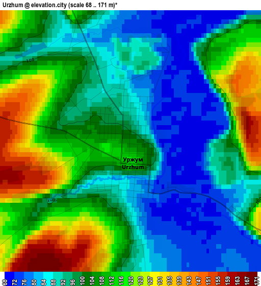
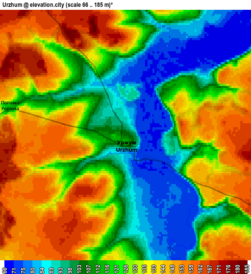
Below is the Elevation map of Urzhum, which displays elevation range with different colors. Scale of the first map is from 68 to 171 m (223 to 561 ft) with average elevation of 101.3 meters (=332 ft) [note 1]
These maps also provides idea of topography and contour of this city, they are displayed at different zoom levels. More info about maps, scale and edge coordinates you can find below images.
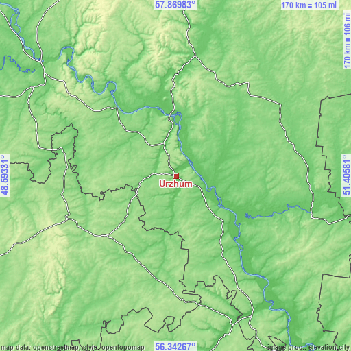
| \ | Map #1 | Map #2 | Topo.Map |
| Scale [m] | 68..171 m | 66..185 m | × |
| Scale [ft] | 223..561 ft | 217..607 ft | × |
| Average | 101.3 m = 332 ft | 123.4 m = 405 ft | × |
| Width | 5.31 km = 3.3 mi | 10.61 km = 6.6 mi | 169.8 km = 105.5 mi |
| Height | 5.31 km = 3.3 mi | 10.61 km = 6.6 mi | 169.8 km = 105.5 mi |
| ↑Max Latitude | 57.137973° | 57.161811° | 57.86983° |
| Latitude at center | 57.11412° | 57.11412° | 57.11412° |
| ↓Min Latitude | 57.090251° | 57.066368° | 56.34267° |
| ← Min Longitude | 49.955615° | 49.911669° | 48.59331° |
| Longitude center | 49.99956° | 49.99956° | 49.99956° |
| →Max Longitude | 50.043505° | 50.087451° | 51.40581° |
Nearby cities:
Cities around Urzhum sort by population:
• Sovetsk elevation 109 m
81.5 km,  309°
309°
• Nolinsk 95 m
49.7 km,  355°
355°
• Malmyzh 76 m
78 km,  147°
147°
• Sernur 157 m
55 km,  248°
248°
• Paran’ga 141 m
58.2 km,  218°
218°
• Kil’mez’ 122 m
67.2 km,  106°
106°
• Mari-Turek 130 m
42.7 km,  212°
212°
• Kuzhener 170 m
74 km,  242°
242°
• Nema 153 m
53 km,  34°
34°
• Arkul’ 75 m
18.7 km,  8°
8°
• Suna 120 m
80.1 km,  2°
2°
• Medvedok 79 m
30.7 km, 3°
Multilingual:
 En español:
Urzhum elevación 104 m.
 En France:
Urzhum élévation 104 m.


Sources and notes:
- [note 1] Map square and city borders are not equal. Map elevation data is calculated only from area inside that square.
- [src 1] Elevation data from geonames database provided with same terms of usage.
- [src 2] The elevation map of Urzhum is generated using elevation data from NASA's 3 arcsec (90m) resolution SRTM data.
- [src 3] Base (background) map © OpenStreetMap contributors tiles are generated by Geofabrik and OpenTopoMap.
Copyright & License:
This Urzhum Elevation Map is licensed under CC BY-SA. You may reuse any part from this page, if you give a proper credit by linking to this URL:
 More info on terms of use page.