Paran’ga elevation
Paran’ga (Mariy-El Republic), Russia elevation is 141 meters and Paran’ga elevation in feet is 463 ft above sea level [src 1]. Paran’ga is a populated place (feature code) with elevation that is 58 meters (190 ft) smaller than average city elevation in Russia.
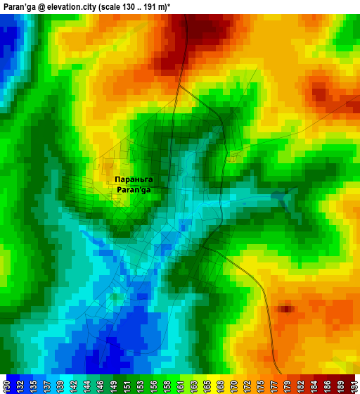
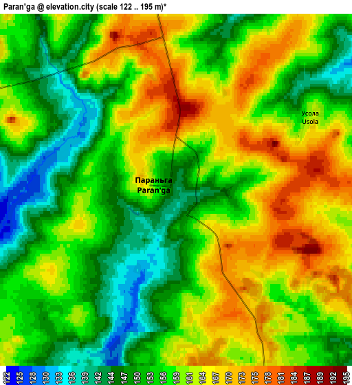
Below is the Elevation map of Paran’ga, which displays elevation range with different colors. Scale of the first map is from 130 to 191 m (427 to 627 ft) with average elevation of 157.5 meters (=517 ft) [note 1]
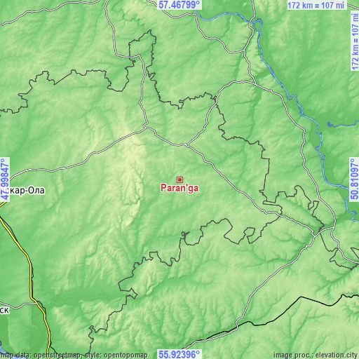
These maps also provides idea of topography and contour of this city, they are displayed at different zoom levels. More info about maps, scale and edge coordinates you can find below images.
| \ | Map #1 | Map #2 | Topo.Map |
| Scale [m] | 130..191 m | 122..195 m | × |
| Scale [ft] | 427..627 ft | 400..640 ft | × |
| Average | 157.5 m = 517 ft | 157.9 m = 518 ft | × |
| Width | 5.36 km = 3.3 mi | 10.73 km = 6.7 mi | 171.7 km = 106.7 mi |
| Height | 5.36 km = 3.3 mi | 10.73 km = 6.7 mi | 171.7 km = 106.7 mi |
| ↑Max Latitude | 56.728007° | 56.752108° | 57.46799° |
| Latitude at center | 56.70389° | 56.70389° | 56.70389° |
| ↓Min Latitude | 56.679758° | 56.65561° | 55.92396° |
| ← Min Longitude | 49.360775° | 49.316829° | 47.99847° |
| Longitude center | 49.40472° | 49.40472° | 49.40472° |
| →Max Longitude | 49.448665° | 49.492611° | 50.81097° |
Nearby cities:
Cities around Paran’ga sort by population:
• Arsk elevation 136 m
74.1 km,  156°
156°
• Urzhum 104 m
58.2 km,  38°
38°
• Sovetskiy 154 m
57 km,  276°
276°
• Morki 107 m
39.5 km,  219°
219°
• Malmyzh 76 m
80.8 km,  104°
104°
• Sernur 157 m
29.7 km,  329°
329°
• Baltasi 104 m
63.2 km,  128°
128°
• Mari-Turek 130 m
16.4 km,  54°
54°
• Kuzhener 170 m
32.3 km,  291°
291°
• Suslonger 100 m
82.8 km,  238°
238°
• Arkul’ 75 m
74.9 km,  31°
31°
• Mochalishche 93 m
76.6 km, 237°
Multilingual:
 En español:
Paran’ga elevación 141 m.
 En France:
Paran’ga élévation 141 m.
 Auf Deutsch:
Paran’ga höhe über dem Meeresspiegel ist 141 m.

Sources and notes:
- [note 1] Map square and city borders are not equal. Map elevation data is calculated only from area inside that square.
- [src 1] Elevation data from geonames database provided with same terms of usage.
- [src 2] The elevation map of Paran’ga is generated using elevation data from NASA's 3 arcsec (90m) resolution SRTM data.
- [src 3] Base (background) map © OpenStreetMap contributors tiles are generated by Geofabrik and OpenTopoMap.
Copyright & License:
This Paran’ga Elevation Map is licensed under CC BY-SA. You may reuse any part from this page, if you give a proper credit by linking to this URL:
 More info on terms of use page.