Sovetskiy elevation
Sovetskiy (Mariy-El Republic), Russia elevation is 154 meters and Sovetskiy elevation in feet is 505 ft above sea level [src 1]. Sovetskiy is a populated place (feature code) with elevation that is 45 meters (148 ft) smaller than average city elevation in Russia.
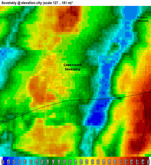
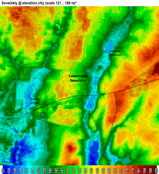
Below is the Elevation map of Sovetskiy, which displays elevation range with different colors. Scale of the first map is from 127 to 181 m (417 to 594 ft) with average elevation of 152.8 meters (=501 ft) [note 1]
These maps also provides idea of topography and contour of this city, they are displayed at different zoom levels. More info about maps, scale and edge coordinates you can find below images.
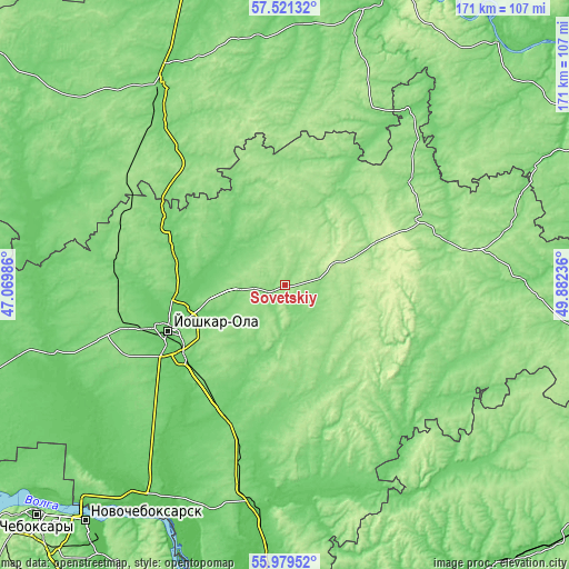
| \ | Map #1 | Map #2 | Topo.Map |
| Scale [m] | 127..181 m | 121..189 m | × |
| Scale [ft] | 417..594 ft | 397..620 ft | × |
| Average | 152.8 m = 501 ft | 152.9 m = 502 ft | × |
| Width | 5.36 km = 3.3 mi | 10.71 km = 6.7 mi | 171.4 km = 106.5 mi |
| Height | 5.36 km = 3.3 mi | 10.71 km = 6.7 mi | 171.4 km = 106.5 mi |
| ↑Max Latitude | 56.782412° | 56.806478° | 57.52132° |
| Latitude at center | 56.75833° | 56.75833° | 56.75833° |
| ↓Min Latitude | 56.734233° | 56.71012° | 55.97952° |
| ← Min Longitude | 48.432165° | 48.388219° | 47.06986° |
| Longitude center | 48.47611° | 48.47611° | 48.47611° |
| →Max Longitude | 48.520055° | 48.564001° | 49.88236° |
Nearby cities:
Cities around Sovetskiy sort by population:
• Yoshkar-Ola elevation 94 m
38.1 km,  249°
249°
• Medvedevo 114 m
43.3 km, 251°
• Morki 107 m
48.4 km,  138°
138°
• Sernur 157 m
45.6 km,  64°
64°
• Krasnogorskiy 82 m
68 km,  187°
187°
• Orshanka 114 m
39.5 km,  296°
296°
• Paran’ga 141 m
57 km,  96°
96°
• Mari-Turek 130 m
70 km,  87°
87°
• Kuzhener 170 m
27.2 km,  77°
77°
• Suslonger 100 m
51.1 km,  195°
195°
• Surok 108 m
40.9 km,  212°
212°
• Mochalishche 93 m
48.1 km, 188°
Multilingual:
 En español:
Sovetskiy elevación 154 m.
 En France:
Sovetskiy élévation 154 m.
 Auf Deutsch:
Sovetskiy höhe über dem Meeresspiegel ist 154 m.

Sources and notes:
- [note 1] Map square and city borders are not equal. Map elevation data is calculated only from area inside that square.
- [src 1] Elevation data from geonames database provided with same terms of usage.
- [src 2] The elevation map of Sovetskiy is generated using elevation data from NASA's 3 arcsec (90m) resolution SRTM data.
- [src 3] Base (background) map © OpenStreetMap contributors tiles are generated by Geofabrik and OpenTopoMap.
Copyright & License:
This Sovetskiy Elevation Map is licensed under CC BY-SA. You may reuse any part from this page, if you give a proper credit by linking to this URL:
 More info on terms of use page.