Kotel’nikovo elevation
Kotel’nikovo (Volgograd Oblast), Russia elevation is 50 meters and Kotel’nikovo elevation in feet is 164 ft above sea level [src 1]. Kotel’nikovo is a populated place (feature code) with elevation that is 149 meters (489 ft) smaller than average city elevation in Russia.
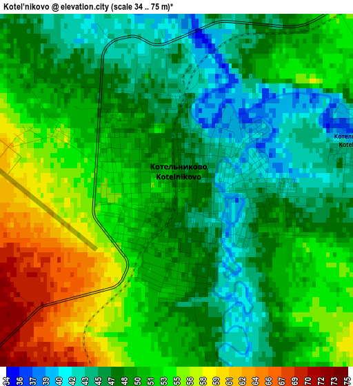
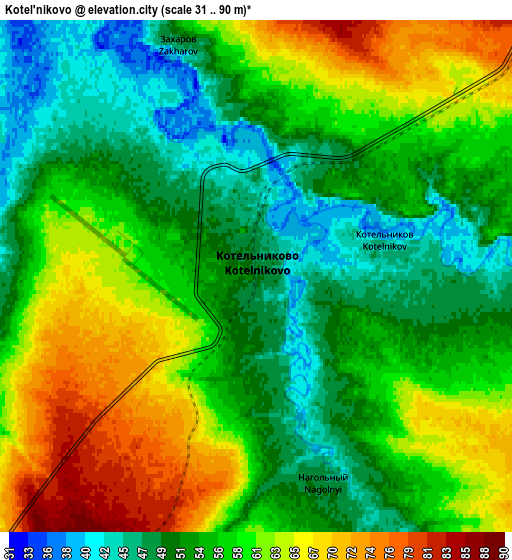
Below is the Elevation map of Kotel’nikovo, which displays elevation range with different colors. Scale of the first map is from 34 to 75 m (112 to 246 ft) with average elevation of 50.2 meters (=165 ft) [note 1]
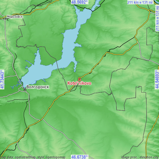
These maps also provides idea of topography and contour of this city, they are displayed at different zoom levels. More info about maps, scale and edge coordinates you can find below images.
| \ | Map #1 | Map #2 | Topo.Map |
| Scale [m] | 34..75 m | 31..90 m | × |
| Scale [ft] | 112..246 ft | 102..295 ft | × |
| Average | 50.2 m = 165 ft | 56.6 m = 186 ft | × |
| Width | 6.59 km = 4.1 mi | 13.17 km = 8.2 mi | 210.7 km = 130.9 mi |
| Height | 6.59 km = 4.1 mi | 13.17 km = 8.2 mi | 210.7 km = 130.9 mi |
| ↑Max Latitude | 47.659697° | 47.689287° | 48.5692° |
| Latitude at center | 47.63009° | 47.63009° | 47.63009° |
| ↓Min Latitude | 47.600466° | 47.570826° | 46.6738° |
| ← Min Longitude | 43.096735° | 43.052789° | 41.73443° |
| Longitude center | 43.14068° | 43.14068° | 43.14068° |
| →Max Longitude | 43.184625° | 43.228571° | 44.54693° |
Nearby cities:
Cities around Kotel’nikovo sort by population:
• Volgodonsk elevation 49 m
75.3 km,  260°
260°
• Zimovniki 65 m
73.6 km,  223°
223°
• Tsimlyansk 82 m
77.8 km,  271°
271°
• Dubovskoye 54 m
36.8 km,  229°
229°
• Romanovskaya 18 m
84 km, 263°
• Zavetnoye 71 m
80.1 km,  135°
135°
• Sadovoye 33 m
104.6 km,  80°
80°
• Krasnoyarskaya 25 m
82.2 km, 271°
• Nizhniy Chir 79 m
81.2 km,  357°
357°
• Krasnoyarskaya 47 m
73.2 km, 258°
• Sovetskoye 57 m
109.8 km,  108°
108°
• Krasnoarmeyskiy 56 m
98.4 km, 225°
Multilingual:
 En español:
Kotel’nikovo elevación 50 m.
 En France:
Kotel’nikovo élévation 50 m.
 Auf Deutsch:
Kotel’nikovo höhe über dem Meeresspiegel ist 50 m.

Sources and notes:
- [note 1] Map square and city borders are not equal. Map elevation data is calculated only from area inside that square.
- [src 1] Elevation data from geonames database provided with same terms of usage.
- [src 2] The elevation map of Kotel’nikovo is generated using elevation data from NASA's 3 arcsec (90m) resolution SRTM data.
- [src 3] Base (background) map © OpenStreetMap contributors tiles are generated by Geofabrik and OpenTopoMap.
Copyright & License:
This Kotel’nikovo Elevation Map is licensed under CC BY-SA. You may reuse any part from this page, if you give a proper credit by linking to this URL:
 More info on terms of use page.