Zimovniki elevation
Zimovniki (Rostov), Russia elevation is 65 meters and Zimovniki elevation in feet is 213 ft above sea level [src 1]. Zimovniki is a seat of a second-order administrative division (feature code) with elevation that is 134 meters (440 ft) smaller than average city elevation in Russia.
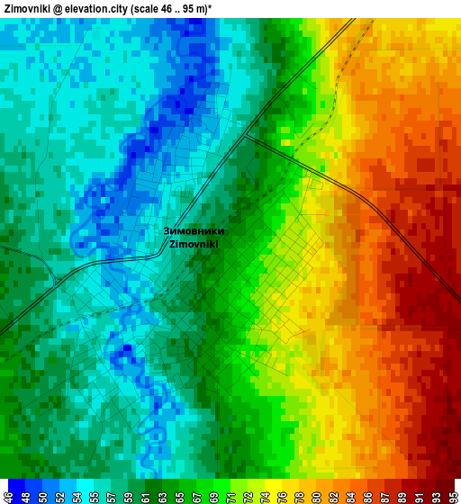
Below is the Elevation map of Zimovniki, which displays elevation range with different colors. Scale of the first map is from 46 to 95 m (151 to 312 ft) with average elevation of 66.9 meters (=219 ft) [note 1]
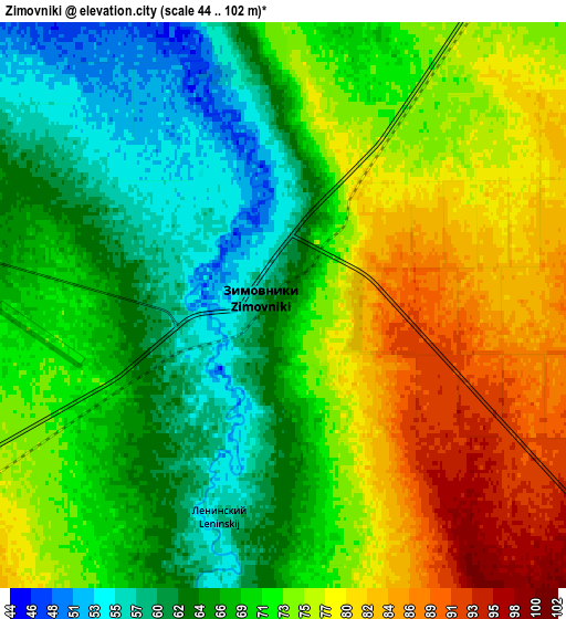
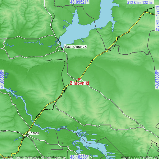
These maps also provides idea of topography and contour of this city, they are displayed at different zoom levels. More info about maps, scale and edge coordinates you can find below images.
| \ | Map #1 | Map #2 | Topo.Map |
| Scale [m] | 46..95 m | 44..102 m | × |
| Scale [ft] | 151..312 ft | 144..335 ft | × |
| Average | 66.9 m = 219 ft | 70.8 m = 232 ft | × |
| Width | 6.65 km = 4.1 mi | 13.29 km = 8.3 mi | 212.7 km = 132.2 mi |
| Height | 6.65 km = 4.1 mi | 13.29 km = 8.3 mi | 212.7 km = 132.2 mi |
| ↑Max Latitude | 47.177279° | 47.207142° | 48.09521° |
| Latitude at center | 47.1474° | 47.1474° | 47.1474° |
| ↓Min Latitude | 47.117504° | 47.087591° | 46.18238° |
| ← Min Longitude | 42.428155° | 42.384209° | 41.06585° |
| Longitude center | 42.4721° | 42.4721° | 42.4721° |
| →Max Longitude | 42.516045° | 42.559991° | 43.87835° |
Nearby cities:
Cities around Zimovniki sort by population:
• Volgodonsk elevation 49 m
47.4 km,  329°
329°
• Kotel’nikovo 50 m
73.6 km,  43°
43°
• Orlovskiy 108 m
43.8 km,  225°
225°
• Tsimlyansk 82 m
62.1 km, 333°
• Dubovskoye 54 m
37.2 km, 37°
• Romanovskaya 18 m
55.2 km,  322°
322°
• Gundorovskiy 68 m
59.8 km, 226°
• Krasnoyarskaya 25 m
64.5 km, 330°
• Krasnoyarskaya 47 m
44.3 km, 330°
• Krasnoarmeyskiy 56 m
25.1 km, 232°
• Bol’shaya Martynovka 27 m
62.4 km,  283°
283°
• Sovetskoye 144 m
53.4 km,  207°
207°
Multilingual:
 En español:
Zimovniki elevación 65 m.
 En France:
Zimovniki élévation 65 m.
 Auf Deutsch:
Zimovniki höhe über dem Meeresspiegel ist 65 m.

Sources and notes:
- [note 1] Map square and city borders are not equal. Map elevation data is calculated only from area inside that square.
- [src 1] Elevation data from geonames database provided with same terms of usage.
- [src 2] The elevation map of Zimovniki is generated using elevation data from NASA's 3 arcsec (90m) resolution SRTM data.
- [src 3] Base (background) map © OpenStreetMap contributors tiles are generated by Geofabrik and OpenTopoMap.
Copyright & License:
This Zimovniki Elevation Map is licensed under CC BY-SA. You may reuse any part from this page, if you give a proper credit by linking to this URL:
 More info on terms of use page.