Sovetskoye elevation
Sovetskoye (Kalmykiya Republic), Russia elevation is 57 meters and Sovetskoye elevation in feet is 187 ft above sea level [src 1]. Sovetskoye is a populated place (feature code) with elevation that is 142 meters (466 ft) smaller than average city elevation in Russia.
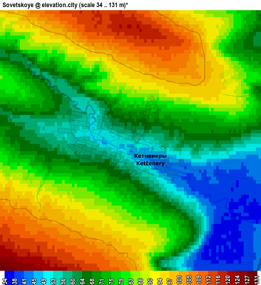
Below is the Elevation map of Sovetskoye, which displays elevation range with different colors. Scale of the first map is from 34 to 131 m (112 to 430 ft) with average elevation of 77.7 meters (=255 ft) [note 1]
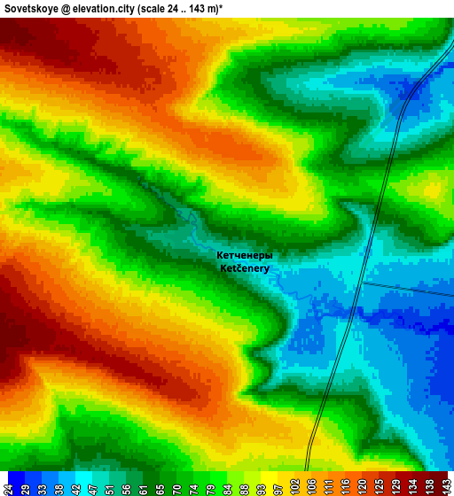
These maps also provides idea of topography and contour of this city, they are displayed at different zoom levels. More info about maps, scale and edge coordinates you can find below images.
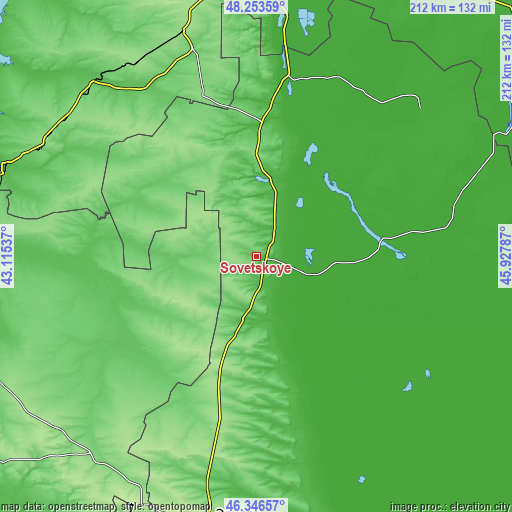
| \ | Map #1 | Map #2 | Topo.Map |
| Scale [m] | 34..131 m | 24..143 m | × |
| Scale [ft] | 112..430 ft | 79..469 ft | × |
| Average | 77.7 m = 255 ft | 81.7 m = 268 ft | × |
| Width | 6.63 km = 4.1 mi | 13.25 km = 8.2 mi | 212 km = 131.7 mi |
| Height | 6.63 km = 4.1 mi | 13.25 km = 8.2 mi | 212 km = 131.7 mi |
| ↑Max Latitude | 47.338469° | 47.36824° | 48.25359° |
| Latitude at center | 47.30868° | 47.30868° | 47.30868° |
| ↓Min Latitude | 47.278875° | 47.249052° | 46.34657° |
| ← Min Longitude | 44.477675° | 44.433729° | 43.11537° |
| Longitude center | 44.52162° | 44.52162° | 44.52162° |
| →Max Longitude | 44.565565° | 44.609511° | 45.92787° |
Nearby cities:
Cities around Sovetskoye sort by population:
• Elista elevation 94 m
113.1 km,  190°
190°
• Kotel’nikovo 50 m
109.8 km,  288°
288°
• Svetlyy Yar 17 m
131.1 km,  8°
8°
• Troitskoye 76 m
100.7 km, 191°
• Dubovskoye 54 m
132.5 km,  275°
275°
• Chyorny Yar 1 m
145.4 km,  54°
54°
• Remontnoye 110 m
106.2 km,  218°
218°
• Yashkul’ -11 m
141.1 km,  153°
153°
• Zavetnoye 71 m
52.1 km,  246°
246°
• Sadovoye 33 m
52.1 km,  359°
359°
• Malyye Derbety 6 m
72.8 km, 9°
• Arshan’ 102 m
117.4 km, 191°
Multilingual:
 En español:
Sovetskoye elevación 57 m.
 En France:
Sovetskoye élévation 57 m.
 Auf Deutsch:
Sovetskoye höhe über dem Meeresspiegel ist 57 m.

Sources and notes:
- [note 1] Map square and city borders are not equal. Map elevation data is calculated only from area inside that square.
- [src 1] Elevation data from geonames database provided with same terms of usage.
- [src 2] The elevation map of Sovetskoye is generated using elevation data from NASA's 3 arcsec (90m) resolution SRTM data.
- [src 3] Base (background) map © OpenStreetMap contributors tiles are generated by Geofabrik and OpenTopoMap.
Copyright & License:
This Sovetskoye Elevation Map is licensed under CC BY-SA. You may reuse any part from this page, if you give a proper credit by linking to this URL:
 More info on terms of use page.