Elista elevation
Elista (Kalmykiya Republic), Russia elevation is 94 meters and Elista elevation in feet is 308 ft above sea level [src 1]. Elista is a seat of a first-order administrative division (feature code) with elevation that is 105 meters (344 ft) smaller than average city elevation in Russia.
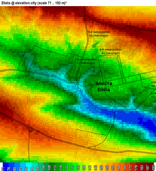
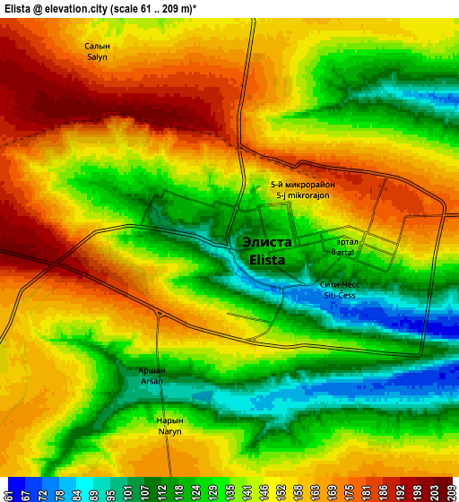
Below is the Elevation map of Elista, which displays elevation range with different colors. Scale of the first map is from 71 to 192 m (233 to 630 ft) with average elevation of 137.3 meters (=450 ft) [note 1]
These maps also provides idea of topography and contour of this city, they are displayed at different zoom levels. More info about maps, scale and edge coordinates you can find below images.
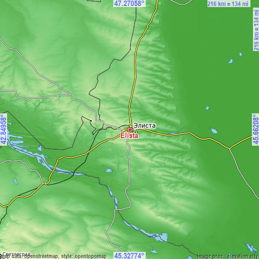
| \ | Map #1 | Map #2 | Topo.Map |
| Scale [m] | 71..192 m | 61..209 m | × |
| Scale [ft] | 233..630 ft | 200..686 ft | × |
| Average | 137.3 m = 450 ft | 143.6 m = 471 ft | × |
| Width | 6.75 km = 4.2 mi | 13.5 km = 8.4 mi | 216 km = 134.2 mi |
| Height | 6.75 km = 4.2 mi | 13.5 km = 8.4 mi | 216 km = 134.2 mi |
| ↑Max Latitude | 46.338128° | 46.36846° | 47.27058° |
| Latitude at center | 46.30778° | 46.30778° | 46.30778° |
| ↓Min Latitude | 46.277415° | 46.247033° | 45.32774° |
| ← Min Longitude | 44.211885° | 44.167939° | 42.84958° |
| Longitude center | 44.25583° | 44.25583° | 44.25583° |
| →Max Longitude | 44.299775° | 44.343721° | 45.66208° |
Nearby cities:
Cities around Elista sort by population:
• Ipatovo elevation 101 m
123.3 km,  237°
237°
• Arzgir 67 m
104 km,  181°
181°
• Divnoye 79 m
82.4 km, 237°
• Troitskoye 76 m
12.5 km,  1°
1°
• Remontnoye 110 m
54.3 km,  301°
301°
• Yashkul’ -11 m
85 km,  100°
100°
• Zavetnoye 71 m
94.5 km,  342°
342°
• Priyutnoye 27 m
62 km,  248°
248°
• Letnyaya Stavka 144 m
115.9 km,  212°
212°
• Sovetskoye 57 m
113.1 km,  10°
10°
• Iki-Burul 117 m
62 km,  150°
150°
• Arshan’ 102 m
4.7 km,  215°
215°
Multilingual:
 En español:
Elistá elevación 94 m.
 En France:
Elista élévation 94 m.


Sources and notes:
- [note 1] Map square and city borders are not equal. Map elevation data is calculated only from area inside that square.
- [src 1] Elevation data from geonames database provided with same terms of usage.
- [src 2] The elevation map of Elista is generated using elevation data from NASA's 3 arcsec (90m) resolution SRTM data.
- [src 3] Base (background) map © OpenStreetMap contributors tiles are generated by Geofabrik and OpenTopoMap.
Copyright & License:
This Elista Elevation Map is licensed under CC BY-SA. You may reuse any part from this page, if you give a proper credit by linking to this URL:
 More info on terms of use page.