Malino elevation
Malino (Moscow Oblast), Russia elevation is 157 meters and Malino elevation in feet is 515 ft above sea level [src 1]. Malino is a populated place (feature code) with elevation that is 42 meters (138 ft) smaller than average city elevation in Russia.
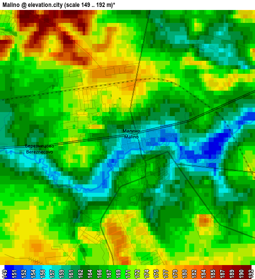
Below is the Elevation map of Malino, which displays elevation range with different colors. Scale of the first map is from 149 to 192 m (489 to 630 ft) with average elevation of 168 meters (=551 ft) [note 1]
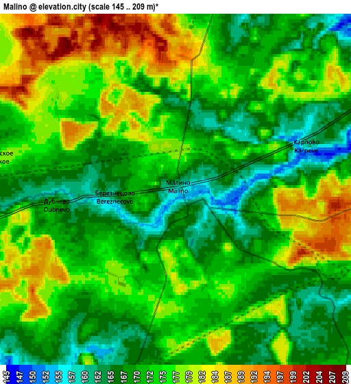
These maps also provides idea of topography and contour of this city, they are displayed at different zoom levels. More info about maps, scale and edge coordinates you can find below images.
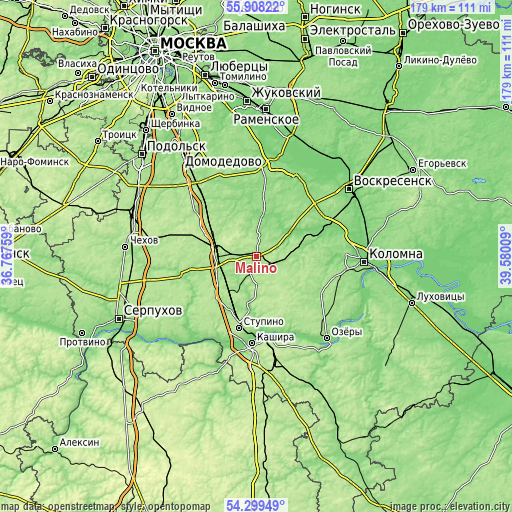
| \ | Map #1 | Map #2 | Topo.Map |
| Scale [m] | 149..192 m | 145..209 m | × |
| Scale [ft] | 489..630 ft | 476..686 ft | × |
| Average | 168 m = 551 ft | 173.2 m = 568 ft | × |
| Width | 5.59 km = 3.5 mi | 11.18 km = 6.9 mi | 178.9 km = 111.2 mi |
| Height | 5.59 km = 3.5 mi | 11.18 km = 6.9 mi | 178.9 km = 111.2 mi |
| ↑Max Latitude | 55.137078° | 55.16219° | 55.90822° |
| Latitude at center | 55.11195° | 55.11195° | 55.11195° |
| ↓Min Latitude | 55.086806° | 55.061647° | 54.29949° |
| ← Min Longitude | 38.129895° | 38.085949° | 36.76759° |
| Longitude center | 38.17384° | 38.17384° | 38.17384° |
| →Max Longitude | 38.217785° | 38.261731° | 39.58009° |
Nearby cities:
Cities around Malino sort by population:
• Stupino elevation 186 m
24.4 km,  195°
195°
• Kashira 152 m
29.7 km,  180°
180°
• Mikhnëvo 173 m
14.1 km,  277°
277°
• Belyye Stolby 176 m
31.7 km,  320°
320°
• Barybino 173 m
24.8 km,  314°
314°
• Troitskoye 150 m
30.9 km,  47°
47°
• Il’inskoye 172 m
20.5 km, 318°
• Meshcherino 126 m
15.1 km, 51°
• Zhitnevo 152 m
30.4 km,  327°
327°
• Zhilëvo 166 m
15 km,  223°
223°
• Biorki 182 m
28.4 km,  103°
103°
• Pervomayskiy 163 m
31.6 km, 99°
Multilingual:
 En español:
Malino elevación 157 m.
 En France:
Malino élévation 157 m.


Sources and notes:
- [note 1] Map square and city borders are not equal. Map elevation data is calculated only from area inside that square.
- [src 1] Elevation data from geonames database provided with same terms of usage.
- [src 2] The elevation map of Malino is generated using elevation data from NASA's 3 arcsec (90m) resolution SRTM data.
- [src 3] Base (background) map © OpenStreetMap contributors tiles are generated by Geofabrik and OpenTopoMap.
Copyright & License:
This Malino Elevation Map is licensed under CC BY-SA. You may reuse any part from this page, if you give a proper credit by linking to this URL:
 More info on terms of use page.