Murmino elevation
Murmino (Ryazan Oblast), Russia elevation is 116 meters and Murmino elevation in feet is 381 ft above sea level [src 1]. Murmino is a populated place (feature code) with elevation that is 83 meters (272 ft) smaller than average city elevation in Russia.
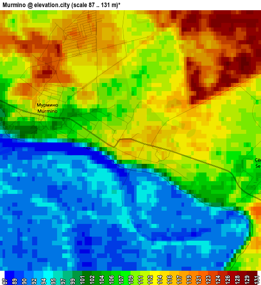
Below is the Elevation map of Murmino, which displays elevation range with different colors. Scale of the first map is from 87 to 131 m (285 to 430 ft) with average elevation of 105.8 meters (=347 ft) [note 1]
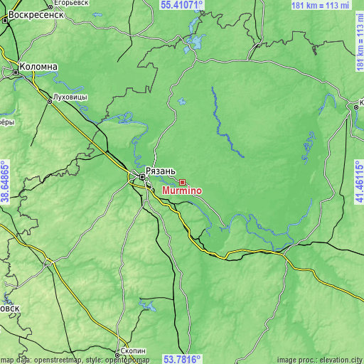
These maps also provides idea of topography and contour of this city, they are displayed at different zoom levels. More info about maps, scale and edge coordinates you can find below images.
| \ | Map #1 | Topo.Map |
| Scale [m] | 87..131 m | × |
| Scale [ft] | 285..430 ft | × |
| Average | 105.8 m = 347 ft | × |
| Width | 5.66 km = 3.5 mi | 181.1 km = 112.5 mi |
| Height | 5.66 km = 3.5 mi | 181.1 km = 112.5 mi |
| ↑Max Latitude | 54.629746° | 55.41071° |
| Latitude at center | 54.6043° | 54.6043° |
| ↓Min Latitude | 54.578838° | 53.7816° |
| ← Min Longitude | 40.010955° | 38.64865° |
| Longitude center | 40.0549° | 40.0549° |
| →Max Longitude | 40.098845° | 41.46115° |
Nearby cities:
Cities around Murmino sort by population:
• Ryazan’ elevation 102 m
23.5 km,  276°
276°
• Rybnoye 104 m
37.2 km,  291°
291°
• Spassk-Ryazanskiy 111 m
30.4 km,  137°
137°
• Lesnoy 137 m
51.2 km,  148°
148°
• Polyany 102 m
19.2 km,  311°
311°
• Spas-Klepiki 117 m
59.5 km,  7°
7°
• Starozhilovo 129 m
43.1 km,  192°
192°
• Izhevskoye 98 m
53.1 km,  95°
95°
• Zakharovo 158 m
56.7 km,  242°
242°
• Solotcha 127 m
25.1 km,  325°
325°
• Bagramovo 124 m
41 km, 288°
• Kiritsy 112 m
40.4 km, 151°
Multilingual:
 En español:
Murmino elevación 116 m.
 En France:
Murmino élévation 116 m.


Sources and notes:
- [note 1] Map square and city borders are not equal. Map elevation data is calculated only from area inside that square.
- [src 1] Elevation data from geonames database provided with same terms of usage.
- [src 2] The elevation map of Murmino is generated using elevation data from NASA's 3 arcsec (90m) resolution SRTM data.
- [src 3] Base (background) map © OpenStreetMap contributors tiles are generated by Geofabrik and OpenTopoMap.
Copyright & License:
This Murmino Elevation Map is licensed under CC BY-SA. You may reuse any part from this page, if you give a proper credit by linking to this URL:
 More info on terms of use page.