Rybnoye elevation
Rybnoye (Ryazan Oblast), Russia elevation is 104 meters and Rybnoye elevation in feet is 341 ft above sea level [src 1]. Rybnoye is a populated place (feature code) with elevation that is 95 meters (312 ft) smaller than average city elevation in Russia.
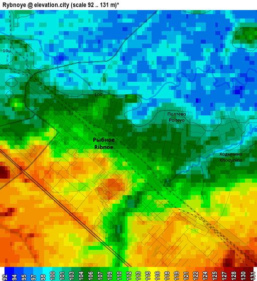
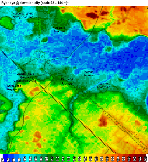
Below is the Elevation map of Rybnoye, which displays elevation range with different colors. Scale of the first map is from 92 to 131 m (302 to 430 ft) with average elevation of 106.9 meters (=351 ft) [note 1]
These maps also provides idea of topography and contour of this city, they are displayed at different zoom levels. More info about maps, scale and edge coordinates you can find below images.
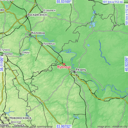
| \ | Map #1 | Map #2 | Topo.Map |
| Scale [m] | 92..131 m | 92..144 m | × |
| Scale [ft] | 302..430 ft | 302..472 ft | × |
| Average | 106.9 m = 351 ft | 111 m = 364 ft | × |
| Width | 5.64 km = 3.5 mi | 11.29 km = 7 mi | 180.6 km = 112.2 mi |
| Height | 5.64 km = 3.5 mi | 11.29 km = 7 mi | 180.6 km = 112.2 mi |
| ↑Max Latitude | 54.753109° | 54.778462° | 55.53169° |
| Latitude at center | 54.72774° | 54.72774° | 54.72774° |
| ↓Min Latitude | 54.702355° | 54.676955° | 53.90752° |
| ← Min Longitude | 39.473365° | 39.429419° | 38.11106° |
| Longitude center | 39.51731° | 39.51731° | 39.51731° |
| →Max Longitude | 39.561255° | 39.605201° | 40.92356° |
Nearby cities:
Cities around Rybnoye sort by population:
• Ryazan’ elevation 102 m
15.9 km,  135°
135°
• Lukhovitsy 118 m
41 km,  312°
312°
• Zaraysk 167 m
41.2 km,  275°
275°
• Serebryanyye Prudy 133 m
58.8 km,  240°
240°
• Beloomut 108 m
26.7 km,  334°
334°
• Polyany 102 m
20.1 km,  93°
93°
• Murmino 116 m
37.2 km,  111°
111°
• Krasnaya Poyma 128 m
41.3 km,  317°
317°
• Zakharovo 158 m
43.1 km,  200°
200°
• Solotcha 127 m
21.4 km,  71°
71°
• Bagramovo 124 m
4.2 km,  263°
263°
• Radovitskiy 126 m
47.9 km,  21°
21°
Multilingual:
 En español:
Rybnoye elevación 104 m.
 En France:
Rybnoye élévation 104 m.


Sources and notes:
- [note 1] Map square and city borders are not equal. Map elevation data is calculated only from area inside that square.
- [src 1] Elevation data from geonames database provided with same terms of usage.
- [src 2] The elevation map of Rybnoye is generated using elevation data from NASA's 3 arcsec (90m) resolution SRTM data.
- [src 3] Base (background) map © OpenStreetMap contributors tiles are generated by Geofabrik and OpenTopoMap.
Copyright & License:
This Rybnoye Elevation Map is licensed under CC BY-SA. You may reuse any part from this page, if you give a proper credit by linking to this URL:
 More info on terms of use page.