Lesnoy elevation
Lesnoy (Ryazan Oblast), Russia elevation is 137 meters and Lesnoy elevation in feet is 449 ft above sea level [src 1]. Lesnoy is a populated place (feature code) with elevation that is 62 meters (203 ft) smaller than average city elevation in Russia.
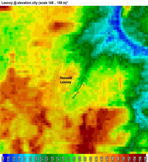
Below is the Elevation map of Lesnoy, which displays elevation range with different colors. Scale of the first map is from 108 to 158 m (354 to 518 ft) with average elevation of 135.5 meters (=445 ft) [note 1]
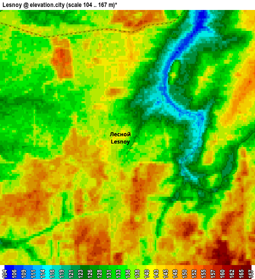
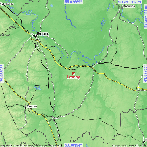
These maps also provides idea of topography and contour of this city, they are displayed at different zoom levels. More info about maps, scale and edge coordinates you can find below images.
| \ | Map #1 | Map #2 | Topo.Map |
| Scale [m] | 108..158 m | 104..167 m | × |
| Scale [ft] | 354..518 ft | 341..548 ft | × |
| Average | 135.5 m = 445 ft | 137.7 m = 452 ft | × |
| Width | 5.71 km = 3.5 mi | 11.43 km = 7.1 mi | 182.9 km = 113.6 mi |
| Height | 5.71 km = 3.5 mi | 11.43 km = 7.1 mi | 182.9 km = 113.6 mi |
| ↑Max Latitude | 54.23819° | 54.263865° | 55.02669° |
| Latitude at center | 54.2125° | 54.2125° | 54.2125° |
| ↓Min Latitude | 54.186794° | 54.161071° | 53.38194° |
| ← Min Longitude | 40.427355° | 40.383409° | 39.06505° |
| Longitude center | 40.4713° | 40.4713° | 40.4713° |
| →Max Longitude | 40.515245° | 40.559191° | 41.87755° |
Nearby cities:
Cities around Lesnoy sort by population:
• Novomichurinsk elevation 119 m
51 km,  247°
247°
• Shilovo 98 m
28.8 km,  65°
65°
• Korablino 138 m
44.5 km,  222°
222°
• Spassk-Ryazanskiy 111 m
22.2 km,  343°
343°
• Ukholovo 152 m
46.7 km,  178°
178°
• Starozhilovo 129 m
36.1 km,  272°
272°
• Sapozhok 133 m
33 km,  155°
155°
• Pronsk 110 m
57.4 km,  257°
257°
• Izhevskoye 98 m
46.4 km,  34°
34°
• Murmino 116 m
51.2 km,  328°
328°
• Putyatino 128 m
42.4 km,  97°
97°
• Kiritsy 112 m
11 km,  317°
317°
Multilingual:
 En español:
Lesnoy elevación 137 m.
 En France:
Lesnoy élévation 137 m.


Sources and notes:
- [note 1] Map square and city borders are not equal. Map elevation data is calculated only from area inside that square.
- [src 1] Elevation data from geonames database provided with same terms of usage.
- [src 2] The elevation map of Lesnoy is generated using elevation data from NASA's 3 arcsec (90m) resolution SRTM data.
- [src 3] Base (background) map © OpenStreetMap contributors tiles are generated by Geofabrik and OpenTopoMap.
Copyright & License:
This Lesnoy Elevation Map is licensed under CC BY-SA. You may reuse any part from this page, if you give a proper credit by linking to this URL:
 More info on terms of use page.