Stavropol’ elevation
Stavropol’ (Stavropol’ Kray), Russia elevation is 575 meters and Stavropol’ elevation in feet is 1886 ft above sea level [src 1]. Stavropol’ is a seat of a first-order administrative division (feature code) with elevation that is 376 meters (1234 ft) bigger than average city elevation in Russia.
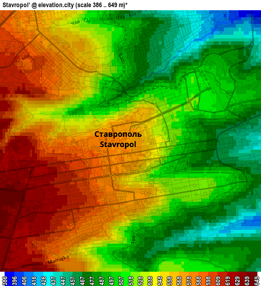
Below is the Elevation map of Stavropol’, which displays elevation range with different colors. Scale of the first map is from 386 to 649 m (1266 to 2129 ft) with average elevation of 532 meters (=1745 ft) [note 1]
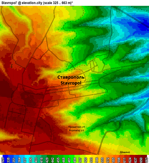
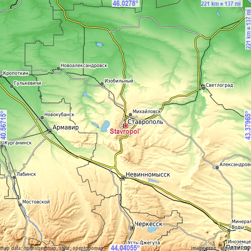
These maps also provides idea of topography and contour of this city, they are displayed at different zoom levels. More info about maps, scale and edge coordinates you can find below images.
| \ | Map #1 | Map #2 | Topo.Map |
| Scale [m] | 386..649 m | 325..663 m | × |
| Scale [ft] | 1266..2129 ft | 1066..2175 ft | × |
| Average | 532 m = 1745 ft | 524.8 m = 1722 ft | × |
| Width | 6.91 km = 4.3 mi | 13.81 km = 8.6 mi | 221 km = 137.3 mi |
| Height | 6.9 km = 4.3 mi | 13.81 km = 8.6 mi | 221 km = 137.3 mi |
| ↑Max Latitude | 45.073842° | 45.104868° | 46.0278° |
| Latitude at center | 45.0428° | 45.0428° | 45.0428° |
| ↓Min Latitude | 45.011741° | 44.980665° | 44.04055° |
| ← Min Longitude | 41.929455° | 41.885509° | 40.56715° |
| Longitude center | 41.9734° | 41.9734° | 41.9734° |
| →Max Longitude | 42.017345° | 42.061291° | 43.37965° |
Nearby cities:
Cities around Stavropol’ sort by population:
• Mikhaylovsk elevation 425 m
10.4 km,  23°
23°
• Izobil’nyy 200 m
42 km,  330°
330°
• Kochubeyevskoye 372 m
45.5 km,  192°
192°
• Ryzdvyanyy 384 m
26.9 km,  336°
336°
• Pelagiada 330 m
18.6 km,  12°
12°
• Tatarka 459 m
9.5 km, 190°
• Barsukovskaya 277 m
33.4 km,  201°
201°
• Moskovskoye 236 m
27.3 km,  349°
349°
• Balakhonovskoye 279 m
33.1 km,  206°
206°
• Beshpagir 342 m
32.1 km,  94°
94°
• Zavetnoye 299 m
44 km,  222°
222°
• Spitsevka 249 m
43.3 km,  78°
78°
Multilingual:
 En español:
Stavropol’ elevación 575 m.
 En France:
Stavropol’ élévation 575 m.
 Auf Deutsch:
Stawropol höhe über dem Meeresspiegel ist 575 m.

Sources and notes:
- [note 1] Map square and city borders are not equal. Map elevation data is calculated only from area inside that square.
- [src 1] Elevation data from geonames database provided with same terms of usage.
- [src 2] The elevation map of Stavropol’ is generated using elevation data from NASA's 3 arcsec (90m) resolution SRTM data.
- [src 3] Base (background) map © OpenStreetMap contributors tiles are generated by Geofabrik and OpenTopoMap.
Copyright & License:
This Stavropol’ Elevation Map is licensed under CC BY-SA. You may reuse any part from this page, if you give a proper credit by linking to this URL:
 More info on terms of use page.