Kochubeyevskoye elevation
Kochubeyevskoye (Stavropol’ Kray), Russia elevation is 372 meters and Kochubeyevskoye elevation in feet is 1220 ft above sea level [src 1]. Kochubeyevskoye is a populated place (feature code) with elevation that is 173 meters (568 ft) bigger than average city elevation in Russia.
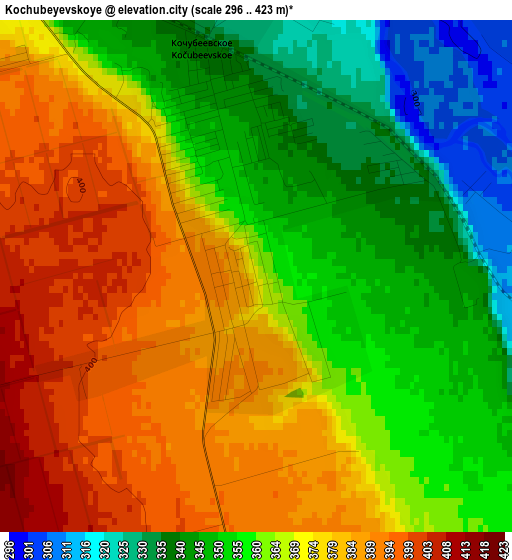
Below is the Elevation map of Kochubeyevskoye, which displays elevation range with different colors. Scale of the first map is from 296 to 423 m (971 to 1388 ft) with average elevation of 365.9 meters (=1200 ft) [note 1]
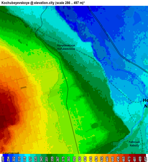
These maps also provides idea of topography and contour of this city, they are displayed at different zoom levels. More info about maps, scale and edge coordinates you can find below images.
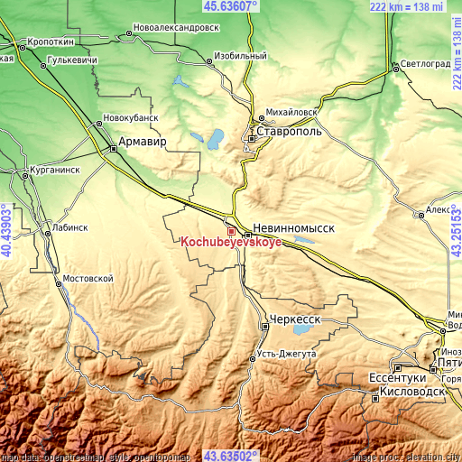
| \ | Map #1 | Map #2 | Topo.Map |
| Scale [m] | 296..423 m | 286..497 m | × |
| Scale [ft] | 971..1388 ft | 938..1631 ft | × |
| Average | 365.9 m = 1200 ft | 362.9 m = 1191 ft | × |
| Width | 6.95 km = 4.3 mi | 13.91 km = 8.6 mi | 222.5 km = 138.3 mi |
| Height | 6.95 km = 4.3 mi | 13.91 km = 8.6 mi | 222.5 km = 138.3 mi |
| ↑Max Latitude | 44.675428° | 44.706669° | 45.63607° |
| Latitude at center | 44.64417° | 44.64417° | 44.64417° |
| ↓Min Latitude | 44.612895° | 44.581603° | 43.63502° |
| ← Min Longitude | 41.801335° | 41.757389° | 40.43903° |
| Longitude center | 41.84528° | 41.84528° | 41.84528° |
| →Max Longitude | 41.889225° | 41.933171° | 43.25153° |
Nearby cities:
Cities around Kochubeyevskoye sort by population:
• Nevinnomyssk elevation 330 m
7.9 km,  98°
98°
• Otradnaya 442 m
38 km,  222°
222°
• Uspenskoye 250 m
41.3 km,  300°
300°
• Ivanovskoye 359 m
7.6 km,  161°
161°
• Poputnaya 407 m
35.3 km,  245°
245°
• Tatarka 459 m
36 km,  13°
13°
• Besskorbnaya 343 m
42.3 km,  270°
270°
• Barsukovskaya 277 m
13.4 km,  351°
351°
• Balakhonovskoye 279 m
15.5 km,  341°
341°
• Ikon-Khalk 476 m
38.1 km,  171°
171°
• Zavetnoye 299 m
22.7 km, 301°
• Adyge-Khabl’ 443 m
35.2 km, 167°
Multilingual:
 En español:
Kochubeyevskoye elevación 372 m.
 En France:
Kochubeyevskoye élévation 372 m.
 Auf Deutsch:
Kotschubejewskoje höhe über dem Meeresspiegel ist 372 m.

Sources and notes:
- [note 1] Map square and city borders are not equal. Map elevation data is calculated only from area inside that square.
- [src 1] Elevation data from geonames database provided with same terms of usage.
- [src 2] The elevation map of Kochubeyevskoye is generated using elevation data from NASA's 3 arcsec (90m) resolution SRTM data.
- [src 3] Base (background) map © OpenStreetMap contributors tiles are generated by Geofabrik and OpenTopoMap.
Copyright & License:
This Kochubeyevskoye Elevation Map is licensed under CC BY-SA. You may reuse any part from this page, if you give a proper credit by linking to this URL:
 More info on terms of use page.