Tatarka elevation
Tatarka (Stavropol’ Kray), Russia elevation is 459 meters and Tatarka elevation in feet is 1506 ft above sea level [src 1]. Tatarka is a populated place (feature code) with elevation that is 260 meters (853 ft) bigger than average city elevation in Russia.
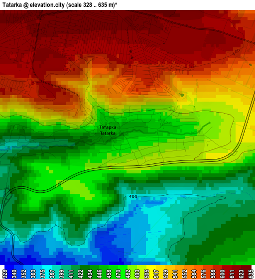
Below is the Elevation map of Tatarka, which displays elevation range with different colors. Scale of the first map is from 328 to 635 m (1076 to 2083 ft) with average elevation of 495 meters (=1624 ft) [note 1]
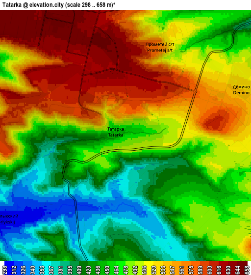
These maps also provides idea of topography and contour of this city, they are displayed at different zoom levels. More info about maps, scale and edge coordinates you can find below images.
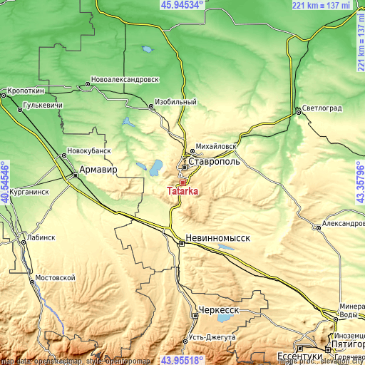
| \ | Map #1 | Map #2 | Topo.Map |
| Scale [m] | 328..635 m | 298..658 m | × |
| Scale [ft] | 1076..2083 ft | 978..2159 ft | × |
| Average | 495 m = 1624 ft | 489.3 m = 1605 ft | × |
| Width | 6.92 km = 4.3 mi | 13.83 km = 8.6 mi | 221.3 km = 137.5 mi |
| Height | 6.92 km = 4.3 mi | 13.83 km = 8.6 mi | 221.3 km = 137.5 mi |
| ↑Max Latitude | 44.989978° | 45.021049° | 45.94534° |
| Latitude at center | 44.95889° | 44.95889° | 44.95889° |
| ↓Min Latitude | 44.927785° | 44.896664° | 43.95518° |
| ← Min Longitude | 41.907765° | 41.863819° | 40.54546° |
| Longitude center | 41.95171° | 41.95171° | 41.95171° |
| →Max Longitude | 41.995655° | 42.039601° | 43.35796° |
Nearby cities:
Cities around Tatarka sort by population:
• Stavropol’ elevation 575 m
9.5 km,  10°
10°
• Nevinnomyssk 330 m
36.2 km,  180°
180°
• Mikhaylovsk 425 m
19.7 km,  17°
17°
• Kochubeyevskoye 372 m
36 km,  193°
193°
• Ryzdvyanyy 384 m
35.2 km,  345°
345°
• Ivanovskoye 359 m
42.6 km, 188°
• Pelagiada 330 m
28.1 km, 11°
• Barsukovskaya 277 m
24.1 km,  205°
205°
• Moskovskoye 236 m
36.3 km, 354°
• Balakhonovskoye 279 m
24.2 km, 213°
• Beshpagir 342 m
34.5 km,  78°
78°
• Zavetnoye 299 m
36.3 km,  229°
229°
Multilingual:
 En español:
Tatarka elevación 459 m.
 En France:
Tatarka élévation 459 m.


Sources and notes:
- [note 1] Map square and city borders are not equal. Map elevation data is calculated only from area inside that square.
- [src 1] Elevation data from geonames database provided with same terms of usage.
- [src 2] The elevation map of Tatarka is generated using elevation data from NASA's 3 arcsec (90m) resolution SRTM data.
- [src 3] Base (background) map © OpenStreetMap contributors tiles are generated by Geofabrik and OpenTopoMap.
Copyright & License:
This Tatarka Elevation Map is licensed under CC BY-SA. You may reuse any part from this page, if you give a proper credit by linking to this URL:
 More info on terms of use page.