Verkhneyarkeyevo elevation
Verkhneyarkeyevo (Bashkortostan Republic), Russia elevation is 92 meters and Verkhneyarkeyevo elevation in feet is 302 ft above sea level [src 1]. Verkhneyarkeyevo is a populated place (feature code) with elevation that is 107 meters (351 ft) smaller than average city elevation in Russia.
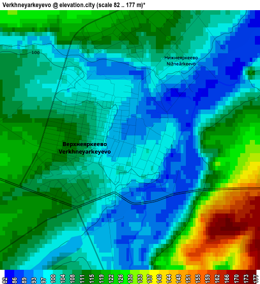
Below is the Elevation map of Verkhneyarkeyevo, which displays elevation range with different colors. Scale of the first map is from 82 to 177 m (269 to 581 ft) with average elevation of 108.3 meters (=355 ft) [note 1]
These maps also provides idea of topography and contour of this city, they are displayed at different zoom levels. More info about maps, scale and edge coordinates you can find below images.

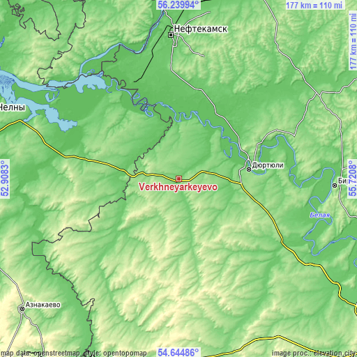
| \ | Map #1 | Map #2 | Topo.Map |
| Scale [m] | 82..177 m | 80..192 m | × |
| Scale [ft] | 269..581 ft | 262..630 ft | × |
| Average | 108.3 m = 355 ft | 124.5 m = 408 ft | × |
| Width | 5.54 km = 3.4 mi | 11.08 km = 6.9 mi | 177.4 km = 110.2 mi |
| Height | 5.54 km = 3.4 mi | 11.08 km = 6.9 mi | 177.3 km = 110.2 mi |
| ↑Max Latitude | 55.475374° | 55.500273° | 56.23994° |
| Latitude at center | 55.45046° | 55.45046° | 55.45046° |
| ↓Min Latitude | 55.42553° | 55.400584° | 54.64486° |
| ← Min Longitude | 54.270605° | 54.226659° | 52.9083° |
| Longitude center | 54.31455° | 54.31455° | 54.31455° |
| →Max Longitude | 54.358495° | 54.402441° | 55.7208° |
Nearby cities:
Cities around Verkhneyarkeyevo sort by population:
• Neftekamsk elevation 108 m
71.4 km,  357°
357°
• Dyurtyuli 86 m
35.2 km,  82°
82°
• Agidel’ 82 m
56.1 km,  334°
334°
• Chekmagush 148 m
41.5 km,  148°
148°
• Bakaly 108 m
44.3 km,  227°
227°
• Aktanysh 67 m
33.5 km, 334°
• Krasnokholmskiy 106 m
75.3 km,  37°
37°
• Muslyumovo 77 m
72.6 km,  256°
256°
• Sharan 160 m
73.3 km,  195°
195°
• Karakulino 112 m
73.1 km, 328°
• Kaltasy 126 m
65.3 km,  27°
27°
• Semiletka 162 m
21.5 km,  117°
117°
Multilingual:
 En español:
Verkhneyarkeyevo elevación 92 m.
 En France:
Verkhneyarkeyevo élévation 92 m.
 Auf Deutsch:
Verkhneyarkeyevo höhe über dem Meeresspiegel ist 92 m.

Sources and notes:
- [note 1] Map square and city borders are not equal. Map elevation data is calculated only from area inside that square.
- [src 1] Elevation data from geonames database provided with same terms of usage.
- [src 2] The elevation map of Verkhneyarkeyevo is generated using elevation data from NASA's 3 arcsec (90m) resolution SRTM data.
- [src 3] Base (background) map © OpenStreetMap contributors tiles are generated by Geofabrik and OpenTopoMap.
Copyright & License:
This Verkhneyarkeyevo Elevation Map is licensed under CC BY-SA. You may reuse any part from this page, if you give a proper credit by linking to this URL:
 More info on terms of use page.