Yutsa elevation
Yutsa (Stavropol’ Kray), Russia elevation is 679 meters and Yutsa elevation in feet is 2228 ft above sea level [src 1]. Yutsa is a populated place (feature code) with elevation that is 480 meters (1575 ft) bigger than average city elevation in Russia.
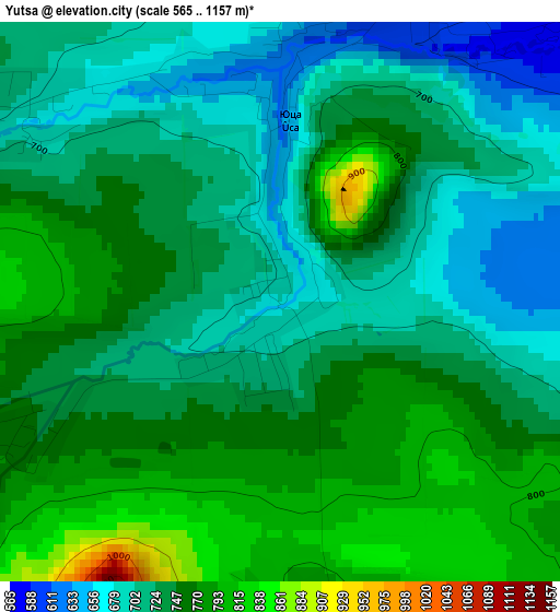
Below is the Elevation map of Yutsa, which displays elevation range with different colors. Scale of the first map is from 565 to 1157 m (1854 to 3796 ft) with average elevation of 736.7 meters (=2417 ft) [note 1]
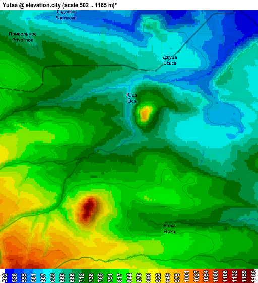
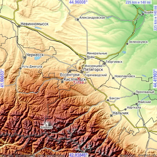
These maps also provides idea of topography and contour of this city, they are displayed at different zoom levels. More info about maps, scale and edge coordinates you can find below images.
| \ | Map #1 | Map #2 | Topo.Map |
| Scale [m] | 565..1157 m | 502..1185 m | × |
| Scale [ft] | 1854..3796 ft | 1647..3888 ft | × |
| Average | 736.7 m = 2417 ft | 740.9 m = 2431 ft | × |
| Width | 7.03 km = 4.4 mi | 14.07 km = 8.7 mi | 225.1 km = 139.9 mi |
| Height | 7.03 km = 4.4 mi | 14.07 km = 8.7 mi | 225.1 km = 139.9 mi |
| ↑Max Latitude | 43.988016° | 44.019626° | 44.96008° |
| Latitude at center | 43.95639° | 43.95639° | 43.95639° |
| ↓Min Latitude | 43.924747° | 43.893087° | 42.93546° |
| ← Min Longitude | 42.968835° | 42.924889° | 41.60653° |
| Longitude center | 43.01278° | 43.01278° | 43.01278° |
| →Max Longitude | 43.056725° | 43.100671° | 44.41903° |
Nearby cities:
Cities around Yutsa sort by population:
• Pyatigorsk elevation 544 m
10.9 km,  19°
19°
• Yessentuki 608 m
15.6 km,  308°
308°
• Goryachevodskiy 505 m
9.8 km,  40°
40°
• Inozemtsevo 483 m
16.4 km, 22°
• Lermontov 668 m
17 km,  349°
349°
• Yessentukskaya 607 m
13.5 km, 308°
• Svobody 495 m
8.3 km, 21°
• Zalukokoazhe 613 m
17.3 km,  109°
109°
• Vinsady 600 m
14.3 km,  344°
344°
• Konstantinovskaya 445 m
15.3 km,  49°
49°
• Pyatigorskiy 484 m
19.8 km,  84°
84°
• Etoka 762 m
5 km,  145°
145°
Multilingual:
 En español:
Yutsa elevación 679 m.
 En France:
Yutsa élévation 679 m.


Sources and notes:
- [note 1] Map square and city borders are not equal. Map elevation data is calculated only from area inside that square.
- [src 1] Elevation data from geonames database provided with same terms of usage.
- [src 2] The elevation map of Yutsa is generated using elevation data from NASA's 3 arcsec (90m) resolution SRTM data.
- [src 3] Base (background) map © OpenStreetMap contributors tiles are generated by Geofabrik and OpenTopoMap.
Copyright & License:
This Yutsa Elevation Map is licensed under CC BY-SA. You may reuse any part from this page, if you give a proper credit by linking to this URL:
 More info on terms of use page.