Inozemtsevo elevation
Inozemtsevo (Stavropol’ Kray), Russia elevation is 483 meters and Inozemtsevo elevation in feet is 1585 ft above sea level [src 1]. Inozemtsevo is a populated place (feature code) with elevation that is 284 meters (932 ft) bigger than average city elevation in Russia.
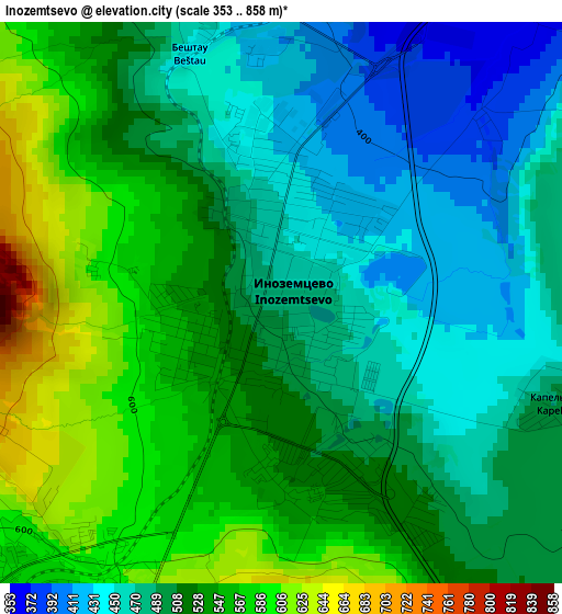
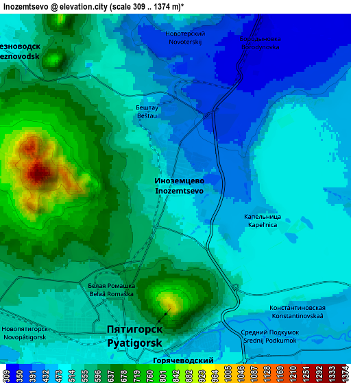
Below is the Elevation map of Inozemtsevo, which displays elevation range with different colors. Scale of the first map is from 353 to 858 m (1158 to 2815 ft) with average elevation of 513.1 meters (=1683 ft) [note 1]
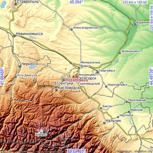
These maps also provides idea of topography and contour of this city, they are displayed at different zoom levels. More info about maps, scale and edge coordinates you can find below images.
| \ | Map #1 | Map #2 | Topo.Map |
| Scale [m] | 353..858 m | 309..1374 m | × |
| Scale [ft] | 1158..2815 ft | 1014..4508 ft | × |
| Average | 513.1 m = 1683 ft | 533.2 m = 1749 ft | × |
| Width | 7.02 km = 4.4 mi | 14.04 km = 8.7 mi | 224.6 km = 139.6 mi |
| Height | 7.02 km = 4.4 mi | 14.04 km = 8.7 mi | 224.6 km = 139.6 mi |
| ↑Max Latitude | 44.124194° | 44.155731° | 45.094° |
| Latitude at center | 44.09264° | 44.09264° | 44.09264° |
| ↓Min Latitude | 44.061069° | 44.029482° | 43.07403° |
| ← Min Longitude | 43.047185° | 43.003239° | 41.68488° |
| Longitude center | 43.09113° | 43.09113° | 43.09113° |
| →Max Longitude | 43.135075° | 43.179021° | 44.49738° |
Nearby cities:
Cities around Inozemtsevo sort by population:
• Pyatigorsk elevation 544 m
5.5 km,  207°
207°
• Mineralnye Vody 310 m
13.5 km,  15°
15°
• Goryachevodskiy 505 m
7.7 km,  179°
179°
• Zheleznovodsk 585 m
7.7 km,  312°
312°
• Lermontov 668 m
9.5 km,  279°
279°
• Svobody 495 m
8.1 km,  203°
203°
• Lysogorskaya 355 m
14.8 km,  84°
84°
• Vinsady 600 m
10.1 km,  262°
262°
• Konstantinovskaya 445 m
7.5 km,  134°
134°
• Podkumskiy 406 m
9.7 km,  101°
101°
• Zmeyka 345 m
6.1 km, 23°
• Novoterskiy 396 m
6.2 km,  1°
1°
Multilingual:
 En español:
Inozemtsevo elevación 483 m.
 En France:
Inozemtsevo élévation 483 m.
 Auf Deutsch:
Inozemtsevo höhe über dem Meeresspiegel ist 483 m.

Sources and notes:
- [note 1] Map square and city borders are not equal. Map elevation data is calculated only from area inside that square.
- [src 1] Elevation data from geonames database provided with same terms of usage.
- [src 2] The elevation map of Inozemtsevo is generated using elevation data from NASA's 3 arcsec (90m) resolution SRTM data.
- [src 3] Base (background) map © OpenStreetMap contributors tiles are generated by Geofabrik and OpenTopoMap.
Copyright & License:
This Inozemtsevo Elevation Map is licensed under CC BY-SA. You may reuse any part from this page, if you give a proper credit by linking to this URL:
 More info on terms of use page.