Yessentukskaya elevation
Yessentukskaya (Stavropol’ Kray), Russia elevation is 607 meters and Yessentukskaya elevation in feet is 1991 ft above sea level [src 1]. Yessentukskaya is a populated place (feature code) with elevation that is 408 meters (1339 ft) bigger than average city elevation in Russia.
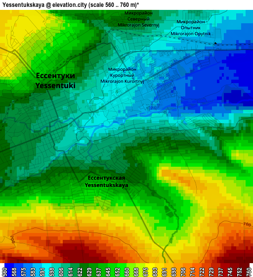
Below is the Elevation map of Yessentukskaya, which displays elevation range with different colors. Scale of the first map is from 560 to 760 m (1837 to 2493 ft) with average elevation of 637.8 meters (=2093 ft) [note 1]
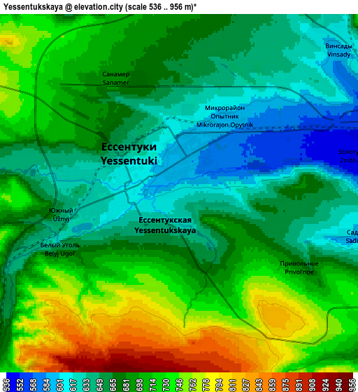
These maps also provides idea of topography and contour of this city, they are displayed at different zoom levels. More info about maps, scale and edge coordinates you can find below images.
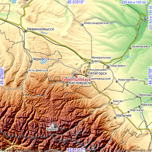
| \ | Map #1 | Map #2 | Topo.Map |
| Scale [m] | 560..760 m | 536..956 m | × |
| Scale [ft] | 1837..2493 ft | 1759..3136 ft | × |
| Average | 637.8 m = 2093 ft | 687.2 m = 2255 ft | × |
| Width | 7.03 km = 4.4 mi | 14.05 km = 8.7 mi | 224.8 km = 139.7 mi |
| Height | 7.03 km = 4.4 mi | 14.05 km = 8.7 mi | 224.8 km = 139.7 mi |
| ↑Max Latitude | 44.064386° | 44.095955° | 45.03519° |
| Latitude at center | 44.0328° | 44.0328° | 44.0328° |
| ↓Min Latitude | 44.001197° | 43.969578° | 43.01317° |
| ← Min Longitude | 42.837355° | 42.793409° | 41.47505° |
| Longitude center | 42.8813° | 42.8813° | 42.8813° |
| →Max Longitude | 42.925245° | 42.969191° | 44.28755° |
Nearby cities:
Cities around Yessentukskaya sort by population:
• Pyatigorsk elevation 544 m
14.3 km,  82°
82°
• Yessentuki 608 m
2.1 km,  307°
307°
• Goryachevodskiy 505 m
16.9 km,  93°
93°
• Inozemtsevo 483 m
18 km,  68°
68°
• Zheleznovodsk 585 m
16.2 km,  42°
42°
• Lermontov 668 m
11 km, 41°
• Svobody 495 m
13.5 km, 93°
• Vinsady 600 m
8.6 km,  51°
51°
• Yutsa 679 m
13.5 km,  128°
128°
• Yasnaya Polyana 747 m
10.2 km,  263°
263°
• Etoka 762 m
18.4 km, 133°
• Novoblagodarnoye 509 m
12.3 km,  357°
357°
Multilingual:
 En español:
Yessentukskaya elevación 607 m.
 En France:
Yessentukskaya élévation 607 m.
 Auf Deutsch:
Yessentukskaya höhe über dem Meeresspiegel ist 607 m.

Sources and notes:
- [note 1] Map square and city borders are not equal. Map elevation data is calculated only from area inside that square.
- [src 1] Elevation data from geonames database provided with same terms of usage.
- [src 2] The elevation map of Yessentukskaya is generated using elevation data from NASA's 3 arcsec (90m) resolution SRTM data.
- [src 3] Base (background) map © OpenStreetMap contributors tiles are generated by Geofabrik and OpenTopoMap.
Copyright & License:
This Yessentukskaya Elevation Map is licensed under CC BY-SA. You may reuse any part from this page, if you give a proper credit by linking to this URL:
 More info on terms of use page.