Yartsevo elevation
Yartsevo (Smolensk), Russia elevation is 204 meters and Yartsevo elevation in feet is 669 ft above sea level [src 1]. Yartsevo is a populated place (feature code) with elevation that is 5 meters (16 ft) bigger than average city elevation in Russia.
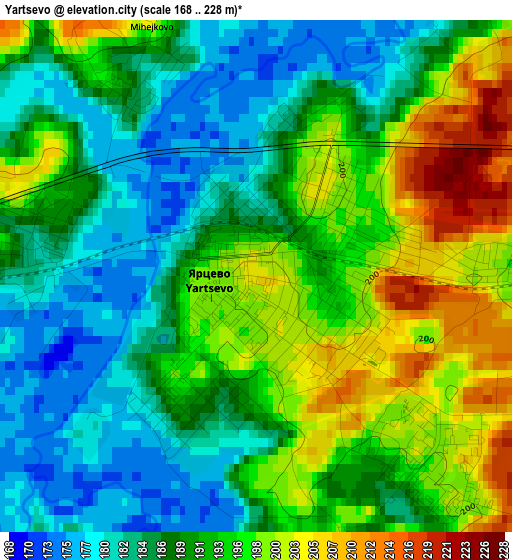
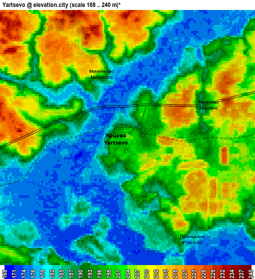
Below is the Elevation map of Yartsevo, which displays elevation range with different colors. Scale of the first map is from 168 to 228 m (551 to 748 ft) with average elevation of 190.9 meters (=626 ft) [note 1]
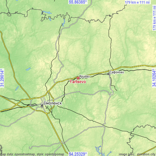
These maps also provides idea of topography and contour of this city, they are displayed at different zoom levels. More info about maps, scale and edge coordinates you can find below images.
| \ | Map #1 | Map #2 | Topo.Map |
| Scale [m] | 168..228 m | 168..240 m | × |
| Scale [ft] | 551..748 ft | 551..787 ft | × |
| Average | 190.9 m = 626 ft | 194 m = 636 ft | × |
| Width | 5.6 km = 3.5 mi | 11.19 km = 7 mi | 179.1 km = 111.3 mi |
| Height | 5.6 km = 3.5 mi | 11.19 km = 7 mi | 179.1 km = 111.3 mi |
| ↑Max Latitude | 55.091826° | 55.116967° | 55.86385° |
| Latitude at center | 55.06667° | 55.06667° | 55.06667° |
| ↓Min Latitude | 55.041498° | 55.01631° | 54.25329° |
| ← Min Longitude | 32.652445° | 32.608499° | 31.29014° |
| Longitude center | 32.69639° | 32.69639° | 32.69639° |
| →Max Longitude | 32.740335° | 32.784281° | 34.10264° |
Nearby cities:
Cities around Yartsevo sort by population:
• Smolensk elevation 250 m
52.6 km,  232°
232°
• Safonovo 217 m
34.5 km,  81°
81°
• Verkhnedneprovskiy 215 m
42.5 km,  102°
102°
• Dorogobuzh 193 m
41.9 km,  113°
113°
• Yel’nya 229 m
62.6 km,  150°
150°
• Ozërnyy 201 m
59.9 km,  342°
342°
• Kardymovo 195 m
25.9 km,  220°
220°
• Dukhovshchina 217 m
22.9 km,  307°
307°
• Pechersk 249 m
48.6 km,  240°
240°
• Kholm-Zhirkovskiy 226 m
70.3 km,  44°
44°
• Glinka 239 m
48.8 km,  166°
166°
• Talashkino 225 m
56.4 km, 215°
Multilingual:
 En español:
Yartsevo elevación 204 m.
 En France:
Yartsevo élévation 204 m.
 Auf Deutsch:
Yartsevo höhe über dem Meeresspiegel ist 204 m.

Sources and notes:
- [note 1] Map square and city borders are not equal. Map elevation data is calculated only from area inside that square.
- [src 1] Elevation data from geonames database provided with same terms of usage.
- [src 2] The elevation map of Yartsevo is generated using elevation data from NASA's 3 arcsec (90m) resolution SRTM data.
- [src 3] Base (background) map © OpenStreetMap contributors tiles are generated by Geofabrik and OpenTopoMap.
Copyright & License:
This Yartsevo Elevation Map is licensed under CC BY-SA. You may reuse any part from this page, if you give a proper credit by linking to this URL:
 More info on terms of use page.