Yel’nya elevation
Yel’nya (Smolensk), Russia elevation is 229 meters and Yel’nya elevation in feet is 751 ft above sea level [src 1]. Yel’nya is a populated place (feature code) with elevation that is 30 meters (98 ft) bigger than average city elevation in Russia.
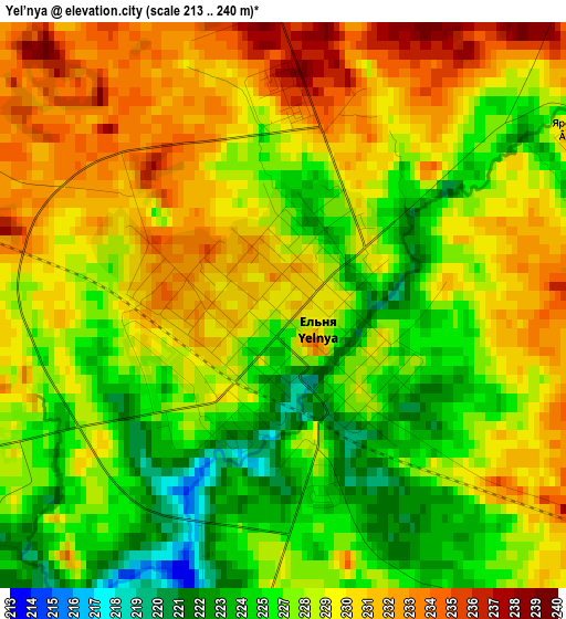
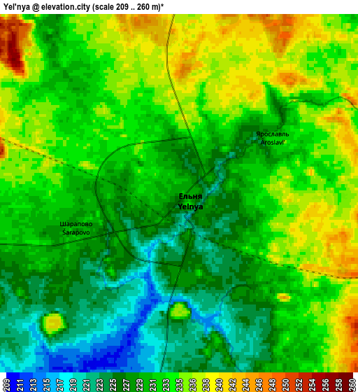
Below is the Elevation map of Yel’nya, which displays elevation range with different colors. Scale of the first map is from 213 to 240 m (699 to 787 ft) with average elevation of 228.2 meters (=749 ft) [note 1]
These maps also provides idea of topography and contour of this city, they are displayed at different zoom levels. More info about maps, scale and edge coordinates you can find below images.
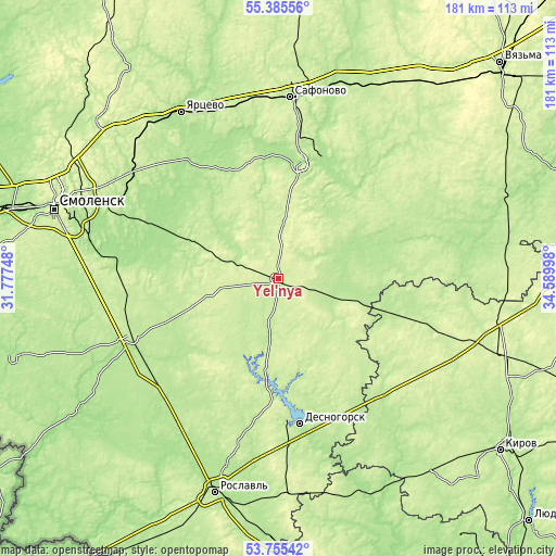
| \ | Map #1 | Map #2 | Topo.Map |
| Scale [m] | 213..240 m | 209..260 m | × |
| Scale [ft] | 699..787 ft | 686..853 ft | × |
| Average | 228.2 m = 749 ft | 231 m = 758 ft | × |
| Width | 5.66 km = 3.5 mi | 11.33 km = 7 mi | 181.3 km = 112.7 mi |
| Height | 5.66 km = 3.5 mi | 11.33 km = 7 mi | 181.2 km = 112.6 mi |
| ↑Max Latitude | 54.604102° | 54.629548° | 55.38556° |
| Latitude at center | 54.57864° | 54.57864° | 54.57864° |
| ↓Min Latitude | 54.553162° | 54.527668° | 53.75542° |
| ← Min Longitude | 33.139785° | 33.095839° | 31.77748° |
| Longitude center | 33.18373° | 33.18373° | 33.18373° |
| →Max Longitude | 33.227675° | 33.271621° | 34.58998° |
Nearby cities:
Cities around Yel’nya sort by population:
• Yartsevo elevation 204 m
62.6 km,  330°
330°
• Safonovo 217 m
59.3 km,  3°
3°
• Desnogorsk 208 m
48 km,  172°
172°
• Verkhnedneprovskiy 215 m
46 km,  13°
13°
• Dorogobuzh 193 m
38.1 km, 11°
• Pochinok 208 m
51.6 km,  248°
248°
• Spas-Demensk 226 m
57.2 km,  108°
108°
• Kardymovo 195 m
59.4 km,  305°
305°
• Shatalovo 191 m
54.9 km,  240°
240°
• Stodolishche 202 m
55.7 km,  218°
218°
• Glinka 239 m
20.8 km,  289°
289°
• Yekimovichi 192 m
52.3 km, 171°
Multilingual:
 En español:
Yel’nya elevación 229 m.
 En France:
Yel’nya élévation 229 m.


Sources and notes:
- [note 1] Map square and city borders are not equal. Map elevation data is calculated only from area inside that square.
- [src 1] Elevation data from geonames database provided with same terms of usage.
- [src 2] The elevation map of Yel’nya is generated using elevation data from NASA's 3 arcsec (90m) resolution SRTM data.
- [src 3] Base (background) map © OpenStreetMap contributors tiles are generated by Geofabrik and OpenTopoMap.
Copyright & License:
This Yel’nya Elevation Map is licensed under CC BY-SA. You may reuse any part from this page, if you give a proper credit by linking to this URL:
 More info on terms of use page.