Ozërnyy elevation
Ozërnyy (Smolensk), Russia elevation is 201 meters and Ozërnyy elevation in feet is 659 ft above sea level [src 1]. Ozërnyy is a populated place (feature code) with elevation that is 2 meters (7 ft) bigger than average city elevation in Russia.
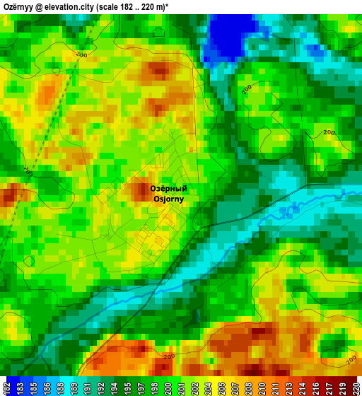
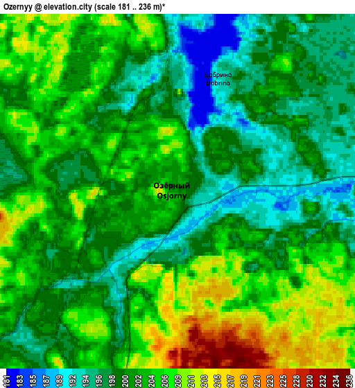
Below is the Elevation map of Ozërnyy, which displays elevation range with different colors. Scale of the first map is from 182 to 220 m (597 to 722 ft) with average elevation of 199.5 meters (=655 ft) [note 1]
These maps also provides idea of topography and contour of this city, they are displayed at different zoom levels. More info about maps, scale and edge coordinates you can find below images.

| \ | Map #1 | Map #2 | Topo.Map |
| Scale [m] | 182..220 m | 181..236 m | × |
| Scale [ft] | 597..722 ft | 594..774 ft | × |
| Average | 199.5 m = 655 ft | 201.9 m = 662 ft | × |
| Width | 5.52 km = 3.4 mi | 11.05 km = 6.9 mi | 176.8 km = 109.9 mi |
| Height | 5.52 km = 3.4 mi | 11.05 km = 6.9 mi | 176.8 km = 109.9 mi |
| ↑Max Latitude | 55.605032° | 55.629849° | 56.36707° |
| Latitude at center | 55.5802° | 55.5802° | 55.5802° |
| ↓Min Latitude | 55.555352° | 55.530488° | 54.77724° |
| ← Min Longitude | 32.368755° | 32.324809° | 31.00645° |
| Longitude center | 32.4127° | 32.4127° | 32.4127° |
| →Max Longitude | 32.456645° | 32.500591° | 33.81895° |
Nearby cities:
Cities around Ozërnyy sort by population:
• Yartsevo elevation 204 m
59.9 km,  162°
162°
• Safonovo 217 m
73.6 km,  135°
135°
• Nelidovo 194 m
74.8 km,  17°
17°
• Zapadnaya Dvina 190 m
78.4 km,  344°
344°
• Demidov 159 m
66.3 km,  238°
238°
• Velizh 164 m
76.5 km,  272°
272°
• Kardymovo 195 m
76.7 km,  179°
179°
• Zharkovskiy 175 m
31.2 km, 343°
• Dukhovshchina 217 m
43.2 km, 180°
• Belyy 180 m
44 km,  48°
48°
• Pechersk 249 m
84.3 km,  196°
196°
• Kholm-Zhirkovskiy 226 m
67 km,  95°
95°
Multilingual:
 En español:
Ozërnyy elevación 201 m.
 En France:
Ozërnyy élévation 201 m.


Sources and notes:
- [note 1] Map square and city borders are not equal. Map elevation data is calculated only from area inside that square.
- [src 1] Elevation data from geonames database provided with same terms of usage.
- [src 2] The elevation map of Ozërnyy is generated using elevation data from NASA's 3 arcsec (90m) resolution SRTM data.
- [src 3] Base (background) map © OpenStreetMap contributors tiles are generated by Geofabrik and OpenTopoMap.
Copyright & License:
This Ozërnyy Elevation Map is licensed under CC BY-SA. You may reuse any part from this page, if you give a proper credit by linking to this URL:
 More info on terms of use page.