Yelets elevation
Yelets (Lipetsk Oblast), Russia elevation is 166 meters and Yelets elevation in feet is 545 ft above sea level [src 1]. Yelets is a populated place (feature code) with elevation that is 33 meters (108 ft) smaller than average city elevation in Russia.
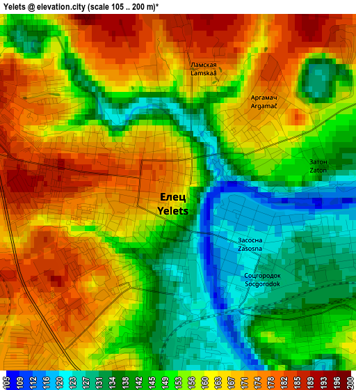
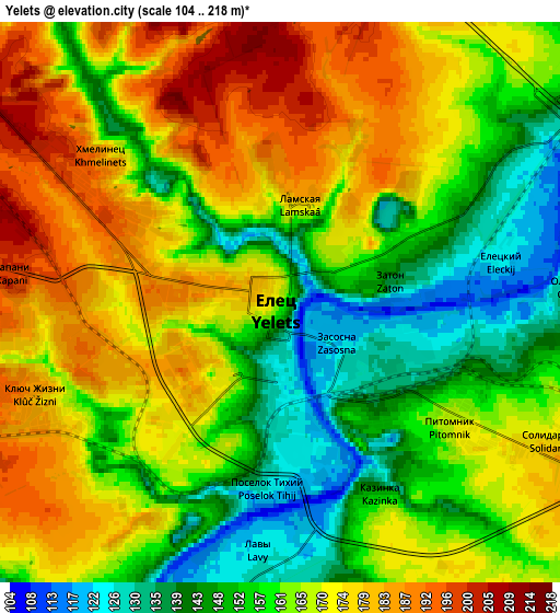
Below is the Elevation map of Yelets, which displays elevation range with different colors. Scale of the first map is from 105 to 200 m (344 to 656 ft) with average elevation of 155.2 meters (=509 ft) [note 1]
These maps also provides idea of topography and contour of this city, they are displayed at different zoom levels. More info about maps, scale and edge coordinates you can find below images.
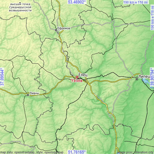
| \ | Map #1 | Map #2 | Topo.Map |
| Scale [m] | 105..200 m | 104..218 m | × |
| Scale [ft] | 344..656 ft | 341..715 ft | × |
| Average | 155.2 m = 509 ft | 163.9 m = 538 ft | × |
| Width | 5.93 km = 3.7 mi | 11.86 km = 7.4 mi | 189.8 km = 117.9 mi |
| Height | 5.93 km = 3.7 mi | 11.86 km = 7.4 mi | 189.8 km = 117.9 mi |
| ↑Max Latitude | 52.650329° | 52.676981° | 53.46902° |
| Latitude at center | 52.62366° | 52.62366° | 52.62366° |
| ↓Min Latitude | 52.596975° | 52.570274° | 51.76165° |
| ← Min Longitude | 38.457745° | 38.413799° | 37.09544° |
| Longitude center | 38.50169° | 38.50169° | 38.50169° |
| →Max Longitude | 38.545635° | 38.589581° | 39.90794° |
Nearby cities:
Cities around Yelets sort by population:
• Lebedyan’ elevation 128 m
62.7 km,  45°
45°
• Zadonsk 127 m
38.7 km,  132°
132°
• Terbuny 225 m
54.8 km,  195°
195°
• Khlevnoye 149 m
62.3 km,  139°
139°
• Borinskoye 143 m
61.7 km,  107°
107°
• Dolgorukovo 194 m
35.4 km, 197°
• Stanovoye 220 m
18.3 km,  328°
328°
• Izmalkovo 245 m
37 km,  281°
281°
• Krasnoye 218 m
33.2 km,  36°
36°
• Donskoye 127 m
31.9 km,  91°
91°
• Kazaki 145 m
16 km,  270°
270°
• Krasnaya Zarya 248 m
58.1 km,  287°
287°
Multilingual:
 En español:
Yelets elevación 166 m.
 En France:
Ielets élévation 166 m.


Sources and notes:
- [note 1] Map square and city borders are not equal. Map elevation data is calculated only from area inside that square.
- [src 1] Elevation data from geonames database provided with same terms of usage.
- [src 2] The elevation map of Yelets is generated using elevation data from NASA's 3 arcsec (90m) resolution SRTM data.
- [src 3] Base (background) map © OpenStreetMap contributors tiles are generated by Geofabrik and OpenTopoMap.
Copyright & License:
This Yelets Elevation Map is licensed under CC BY-SA. You may reuse any part from this page, if you give a proper credit by linking to this URL:
 More info on terms of use page.