Donskoye elevation
Donskoye (Lipetsk Oblast), Russia elevation is 127 meters and Donskoye elevation in feet is 417 ft above sea level [src 1]. Donskoye is a populated place (feature code) with elevation that is 72 meters (236 ft) smaller than average city elevation in Russia.
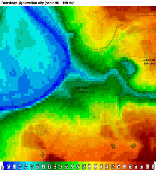
Below is the Elevation map of Donskoye, which displays elevation range with different colors. Scale of the first map is from 98 to 199 m (322 to 653 ft) with average elevation of 144.7 meters (=475 ft) [note 1]
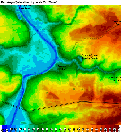
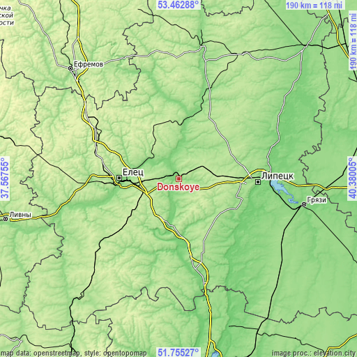
These maps also provides idea of topography and contour of this city, they are displayed at different zoom levels. More info about maps, scale and edge coordinates you can find below images.
| \ | Map #1 | Map #2 | Topo.Map |
| Scale [m] | 98..199 m | 93..214 m | × |
| Scale [ft] | 322..653 ft | 305..702 ft | × |
| Average | 144.7 m = 475 ft | 153.4 m = 503 ft | × |
| Width | 5.93 km = 3.7 mi | 11.87 km = 7.4 mi | 189.9 km = 118 mi |
| Height | 5.93 km = 3.7 mi | 11.87 km = 7.4 mi | 189.9 km = 118 mi |
| ↑Max Latitude | 52.644073° | 52.670729° | 53.46288° |
| Latitude at center | 52.6174° | 52.6174° | 52.6174° |
| ↓Min Latitude | 52.590711° | 52.564006° | 51.75527° |
| ← Min Longitude | 38.929855° | 38.885909° | 37.56755° |
| Longitude center | 38.9738° | 38.9738° | 38.9738° |
| →Max Longitude | 39.017745° | 39.061691° | 40.38005° |
Nearby cities:
Cities around Donskoye sort by population:
• Lipetsk elevation 158 m
40.3 km,  92°
92°
• Yelets 166 m
31.9 km,  271°
271°
• Lebedyan’ 128 m
46.5 km,  16°
16°
• Zadonsk 127 m
25.4 km,  187°
187°
• Khlevnoye 149 m
47.6 km,  170°
170°
• Borinskoye 143 m
32.3 km,  123°
123°
• Dolgorukovo 194 m
53.9 km,  232°
232°
• Stanovoye 220 m
44.6 km,  291°
291°
• Krasnoye 218 m
30 km,  336°
336°
• Syrskoye 177 m
35.6 km,  97°
97°
• Kazaki 145 m
47.9 km, 270°
• Kuz’minskiye Otverzhki 169 m
34.6 km,  75°
75°
Multilingual:
 En español:
Donskoye elevación 127 m.
 En France:
Donskoye élévation 127 m.
 Auf Deutsch:
Donskoye höhe über dem Meeresspiegel ist 127 m.

Sources and notes:
- [note 1] Map square and city borders are not equal. Map elevation data is calculated only from area inside that square.
- [src 1] Elevation data from geonames database provided with same terms of usage.
- [src 2] The elevation map of Donskoye is generated using elevation data from NASA's 3 arcsec (90m) resolution SRTM data.
- [src 3] Base (background) map © OpenStreetMap contributors tiles are generated by Geofabrik and OpenTopoMap.
Copyright & License:
This Donskoye Elevation Map is licensed under CC BY-SA. You may reuse any part from this page, if you give a proper credit by linking to this URL:
 More info on terms of use page.