Terbuny elevation
Terbuny (Lipetsk Oblast), Russia elevation is 225 meters and Terbuny elevation in feet is 738 ft above sea level [src 1]. Terbuny is a populated place (feature code) with elevation that is 26 meters (85 ft) bigger than average city elevation in Russia.
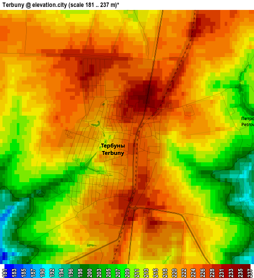
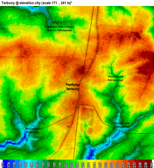
Below is the Elevation map of Terbuny, which displays elevation range with different colors. Scale of the first map is from 181 to 237 m (594 to 778 ft) with average elevation of 217.1 meters (=712 ft) [note 1]
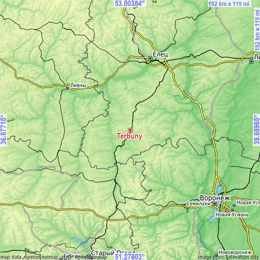
These maps also provides idea of topography and contour of this city, they are displayed at different zoom levels. More info about maps, scale and edge coordinates you can find below images.
| \ | Map #1 | Map #2 | Topo.Map |
| Scale [m] | 181..237 m | 171..241 m | × |
| Scale [ft] | 594..778 ft | 561..791 ft | × |
| Average | 217.1 m = 712 ft | 210.8 m = 692 ft | × |
| Width | 6 km = 3.7 mi | 11.99 km = 7.5 mi | 191.9 km = 119.2 mi |
| Height | 6 km = 3.7 mi | 11.99 km = 7.5 mi | 191.9 km = 119.2 mi |
| ↑Max Latitude | 52.176257° | 52.203198° | 53.00384° |
| Latitude at center | 52.1493° | 52.1493° | 52.1493° |
| ↓Min Latitude | 52.122327° | 52.095337° | 51.27803° |
| ← Min Longitude | 38.239455° | 38.195509° | 36.87715° |
| Longitude center | 38.2834° | 38.2834° | 38.2834° |
| →Max Longitude | 38.327345° | 38.371291° | 39.68965° |
Nearby cities:
Cities around Terbuny sort by population:
• Yelets elevation 166 m
54.8 km,  15°
15°
• Livny 180 m
55.3 km,  303°
303°
• Zadonsk 127 m
51.3 km,  58°
58°
• Kshenskiy 170 m
51.9 km,  228°
228°
• Khlevnoye 149 m
55.5 km,  84°
84°
• Dolgorukovo 194 m
19.4 km,  12°
12°
• Vyshneye Dolgoye 161 m
60.7 km,  260°
260°
• Kastornoye 165 m
36.7 km,  196°
196°
• Volovo 204 m
30.4 km,  243°
243°
• Kazaki 145 m
52.9 km,  358°
358°
• Olym 183 m
52.7 km,  188°
188°
• Zemlyansk 186 m
41.1 km,  131°
131°
Multilingual:
 En español:
Terbuny elevación 225 m.
 En France:
Terbuny élévation 225 m.


Sources and notes:
- [note 1] Map square and city borders are not equal. Map elevation data is calculated only from area inside that square.
- [src 1] Elevation data from geonames database provided with same terms of usage.
- [src 2] The elevation map of Terbuny is generated using elevation data from NASA's 3 arcsec (90m) resolution SRTM data.
- [src 3] Base (background) map © OpenStreetMap contributors tiles are generated by Geofabrik and OpenTopoMap.
Copyright & License:
This Terbuny Elevation Map is licensed under CC BY-SA. You may reuse any part from this page, if you give a proper credit by linking to this URL:
 More info on terms of use page.