Raška elevation
Raška (Central Serbia), Serbia elevation is 414 meters and Raška elevation in feet is 1358 ft above sea level [src 1]. Raška is a seat of a third-order administrative division (feature code) with elevation that is 247 meters (810 ft) bigger than average city elevation in Serbia.
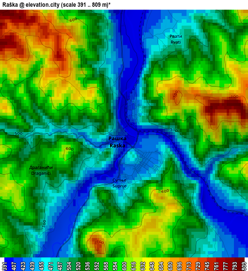
Below is the Elevation map of Raška, which displays elevation range with different colors. Scale of the first map is from 391 to 809 m (1283 to 2654 ft) with average elevation of 538.8 meters (=1768 ft) [note 1]
These maps also provides idea of topography and contour of this city, they are displayed at different zoom levels. More info about maps, scale and edge coordinates you can find below images.

| \ | Map #1 | Topo.Map |
| Scale [m] | 391..809 m | × |
| Scale [ft] | 1283..2654 ft | × |
| Average | 538.8 m = 1768 ft | × |
| Width | 7.11 km = 4.4 mi | 227.6 km = 141.4 mi |
| Height | 7.11 km = 4.4 mi | 227.6 km = 141.4 mi |
| ↑Max Latitude | 43.319201° | 44.30225° |
| Latitude at center | 43.28722° | 43.28722° |
| ↓Min Latitude | 43.255223° | 42.25497° |
| ← Min Longitude | 20.571335° | 19.20903° |
| Longitude center | 20.61528° | 20.61528° |
| →Max Longitude | 20.659225° | 22.02153° |
Nearby cities:
Cities around Raška sort by population:
• Novi Pazar elevation 511 m
18.7 km,  206°
206°
• Kraljevo 207 m
49.1 km,  6°
6°
• Trstenik 170 m
48.2 km,  40°
40°
• Vrnjačka Banja 211 m
44.1 km,  30°
30°
• Osječenik 1421 m
63.3 km,  255°
255°
• Sokolovica 1000 m
25.6 km,  251°
251°
• Tutin 869 m
40.3 km, 214°
• Kuršumlija 367 m
55.8 km,  107°
107°
• Blace 396 m
54.3 km,  89°
89°
• Sjenica 1011 m
49.9 km,  268°
268°
• Ivanjica 466 m
45 km,  316°
316°
• Aleksandrovac 352 m
40.1 km,  61°
61°
Multilingual:
 En español:
Raška elevación 414 m.
 En France:
Raška élévation 414 m.


Sources and notes:
- [note 1] Map square and city borders are not equal. Map elevation data is calculated only from area inside that square.
- [src 1] Elevation data from geonames database provided with same terms of usage.
- [src 2] The elevation map of Raška is generated using elevation data from NASA's 3 arcsec (90m) resolution SRTM data.
- [src 3] Base (background) map © OpenStreetMap contributors tiles are generated by Geofabrik and OpenTopoMap.
Copyright & License:
This Raška Elevation Map is licensed under CC BY-SA. You may reuse any part from this page, if you give a proper credit by linking to this URL:
 More info on terms of use page.