Vrnjačka Banja elevation
Vrnjačka Banja (Central Serbia, Raška), Serbia elevation is 211 meters and Vrnjačka Banja elevation in feet is 692 ft above sea level [src 1]. Vrnjačka Banja is a seat of a third-order administrative division (feature code) with elevation that is 44 meters (144 ft) bigger than average city elevation in Serbia.
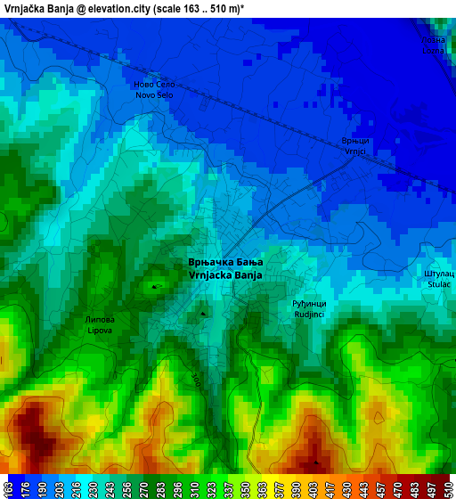
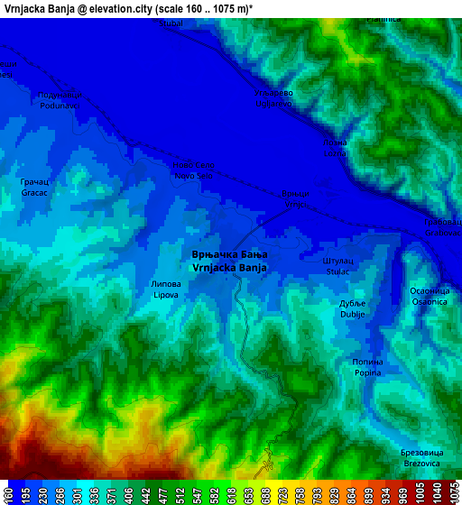
Below is the Elevation map of Vrnjačka Banja, which displays elevation range with different colors. Scale of the first map is from 163 to 510 m (535 to 1673 ft) with average elevation of 252.3 meters (=828 ft) [note 1]
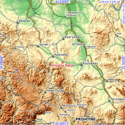
These maps also provides idea of topography and contour of this city, they are displayed at different zoom levels. More info about maps, scale and edge coordinates you can find below images.
| \ | Map #1 | Map #2 | Topo.Map |
| Scale [m] | 163..510 m | 160..1075 m | × |
| Scale [ft] | 535..1673 ft | 525..3527 ft | × |
| Average | 252.3 m = 828 ft | 349.4 m = 1146 ft | × |
| Width | 7.07 km = 4.4 mi | 14.15 km = 8.8 mi | 226.4 km = 140.7 mi |
| Height | 7.07 km = 4.4 mi | 14.15 km = 8.8 mi | 226.4 km = 140.7 mi |
| ↑Max Latitude | 43.659051° | 43.690835° | 44.63653° |
| Latitude at center | 43.62725° | 43.62725° | 43.62725° |
| ↓Min Latitude | 43.595432° | 43.563597° | 42.60073° |
| ← Min Longitude | 20.852395° | 20.808449° | 19.49009° |
| Longitude center | 20.89634° | 20.89634° | 20.89634° |
| →Max Longitude | 20.940285° | 20.984231° | 22.30259° |
Nearby cities:
Cities around Vrnjačka Banja sort by population:
• Kragujevac elevation 182 m
43.3 km,  2°
2°
• Kraljevo 207 m
19.9 km,  303°
303°
• Kruševac 162 m
35.6 km,  98°
98°
• Trstenik 170 m
8.6 km, 97°
• Paraćin 130 m
48.6 km,  57°
57°
• Ćićevac 144 m
45 km,  76°
76°
• Raška 414 m
44.1 km,  210°
210°
• Blace 396 m
48.5 km,  139°
139°
• Varvarin 142 m
39 km,  73°
73°
• Knić 320 m
36.2 km,  336°
336°
• Rekovac 241 m
30.6 km,  31°
31°
• Aleksandrovac 352 m
22.6 km,  146°
146°
Multilingual:
 En español:
Vrnjačka Banja elevación 211 m.
 En France:
Vrnjačka Banja élévation 211 m.
 Auf Deutsch:
Vrnjačka Banja höhe über dem Meeresspiegel ist 211 m.

Sources and notes:
- [note 1] Map square and city borders are not equal. Map elevation data is calculated only from area inside that square.
- [src 1] Elevation data from geonames database provided with same terms of usage.
- [src 2] The elevation map of Vrnjačka Banja is generated using elevation data from NASA's 3 arcsec (90m) resolution SRTM data.
- [src 3] Base (background) map © OpenStreetMap contributors tiles are generated by Geofabrik and OpenTopoMap.
Copyright & License:
This Vrnjačka Banja Elevation Map is licensed under CC BY-SA. You may reuse any part from this page, if you give a proper credit by linking to this URL:
 More info on terms of use page.