Kruševac elevation
Kruševac (Central Serbia, Rasina), Serbia elevation is 162 meters and Kruševac elevation in feet is 531 ft above sea level [src 1]. Kruševac is a seat of a second-order administrative division (feature code) with elevation that is 5 meters (16 ft) smaller than average city elevation in Serbia.
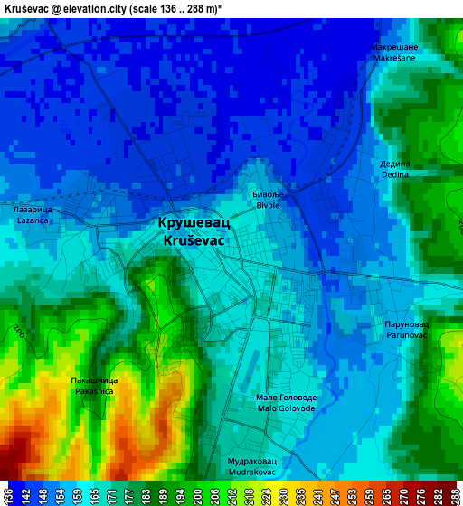
Below is the Elevation map of Kruševac, which displays elevation range with different colors. Scale of the first map is from 136 to 288 m (446 to 945 ft) with average elevation of 168.4 meters (=552 ft) [note 1]
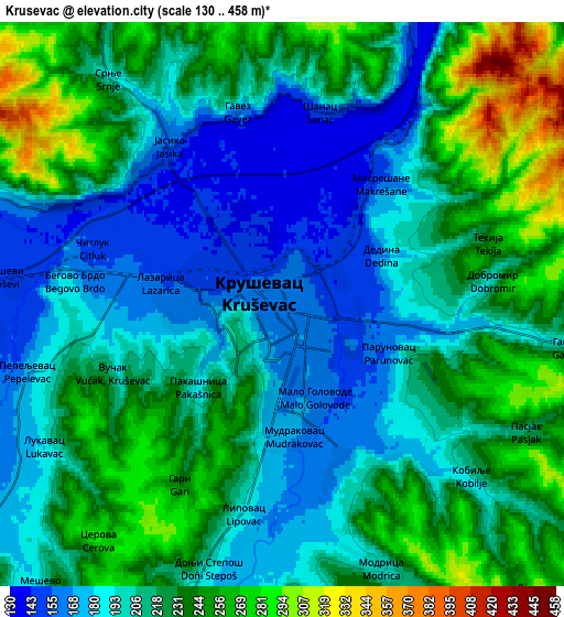
These maps also provides idea of topography and contour of this city, they are displayed at different zoom levels. More info about maps, scale and edge coordinates you can find below images.
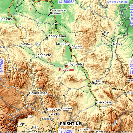
| \ | Map #1 | Map #2 | Topo.Map |
| Scale [m] | 136..288 m | 130..458 m | × |
| Scale [ft] | 446..945 ft | 427..1503 ft | × |
| Average | 168.4 m = 552 ft | 215.3 m = 706 ft | × |
| Width | 7.08 km = 4.4 mi | 14.16 km = 8.8 mi | 226.5 km = 140.7 mi |
| Height | 7.08 km = 4.4 mi | 14.16 km = 8.8 mi | 226.5 km = 140.7 mi |
| ↑Max Latitude | 43.611826° | 43.643635° | 44.59008° |
| Latitude at center | 43.58° | 43.58° | 43.58° |
| ↓Min Latitude | 43.548157° | 43.516297° | 42.55268° |
| ← Min Longitude | 21.289945° | 21.245999° | 19.92764° |
| Longitude center | 21.33389° | 21.33389° | 21.33389° |
| →Max Longitude | 21.377835° | 21.421781° | 22.74014° |
Nearby cities:
Cities around Kruševac sort by population:
• Trstenik elevation 170 m
27 km,  278°
278°
• Prokuplje 259 m
43.6 km,  151°
151°
• Ćuprija 124 m
38.7 km,  4°
4°
• Vrnjačka Banja 211 m
35.6 km, 278°
• Paraćin 130 m
31.8 km,  10°
10°
• Ćićevac 144 m
17.7 km,  29°
29°
• Rekovac 241 m
36.9 km,  328°
328°
• Blace 396 m
31.9 km,  186°
186°
• Aleksinac 169 m
30.4 km,  98°
98°
• Aleksandrovac 352 m
26.4 km,  239°
239°
• Ražanj 262 m
20.2 km,  59°
59°
• Varvarin 142 m
16.2 km, 8°
Multilingual:
 En español:
Kruševac elevación 162 m.
 En France:
Kruševac élévation 162 m.
 Auf Deutsch:
Kruševac höhe über dem Meeresspiegel ist 162 m.

Sources and notes:
- [note 1] Map square and city borders are not equal. Map elevation data is calculated only from area inside that square.
- [src 1] Elevation data from geonames database provided with same terms of usage.
- [src 2] The elevation map of Kruševac is generated using elevation data from NASA's 3 arcsec (90m) resolution SRTM data.
- [src 3] Base (background) map © OpenStreetMap contributors tiles are generated by Geofabrik and OpenTopoMap.
Copyright & License:
This Kruševac Elevation Map is licensed under CC BY-SA. You may reuse any part from this page, if you give a proper credit by linking to this URL:
 More info on terms of use page.